Updated: Dec 09, 2024
Michael Mints1, Arsen Suleimanov2, Robert Berzin2, Andrey Morozov3, Alexander Lipilin3, Nadezhda Zamozhniaya2, Vladimir Stupak2, Alexander Konilov1, Valery Zlobin1
This paper presents a 3-dimensional model of crustal structure under the southeastern Fennoscandian Shield, East European Craton, based on deep seismic reflection profiling and field geological mapping. This paper was presented at the "Supercontinents and Earth Evolution" Symposium, Fremantle, Western Australia, 26-30 September, 2005.
Deep seismic profiling data and images acquired in recent years give a much improved understanding of the tectonics and deep crustal structure of the southeastern part of the Fennoscandian Shield formed towards the end of the Paleoproterozoic (Fig. 1). The area investigated includes the Neoarchean Karelian Craton, the Archean-Paleoproterozoic Belomorian Imbricated Thrust Belt and southeastern edge of the Svecofennian Accretionary Orogen (Fig. 1).
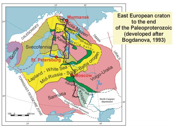
Fig. 1 – Tectonic map of the East Europen Craton showing the study area (outlined),
the location of the deep seismic reflection profiles 1-EU and 4B and the areas shown in Figures 2-7.
The new tectonic understanding of the region resulted from the integration of regional geological and geophysical data with a significant new contribution from modern common-mid-point (CMP) seismic reflection profiling and data processing along the 1-EU Geotraverse (350-1350 km seismic profiling section) and from the 4B cross-traverse 270 km in length (Fig. 1). These seismic profiling transects provide seismic images of the crust and upper mantle from the surface to about 80 km depth (25 s).
The northern Russian sector of the East European Craton contains fragments of some of the Earth's oldest Precambrian building blocks. The region between St. Petersburg and Murmansk (Fig. 1) is prospective for minerals and represents a rich geological asset for countries in the region. An improved understanding of the tectonic framework for the region improves knowledge of the emplacement of minerals and the geological pathways through the Earth's crust for mineral-rich fluids that lead to mineral deposits.
Deep seismic reflection profiling data were acquired across the East European Craton (EEC) from the Barents Sea in the north and southward towards the Caspian Sea (Fig. 1). The Earth's crust and lithosphere were imaged down to 80 km depth (20 s) along the northern part of geo-transect 1-EU (1350 km long) during the years 1995 to 2000 and along the cross-profile 4B (270 km) during 1999. Work currently continues on the southern sector of the profile towards the Caspian Sea (3500 km total).
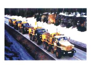
The source and recording parameters for effective vibroseis operation and noise suppression in the south-eastern part of the Fennoscandinavian Shield were determined from field tests.
Features of the wavefield were defined on the basis of both near-surface and deep seismic and geological conditions. The wavefield obtained is extremely varied both in form and in amplitude attributes. It was noted that the wavefield exhibited a limited extent for the strongest P-wave events and their interference characteristics.
| Line 4B | Line 1-EU | |
|---|---|---|
| Recording system | 110-2+SW388 200-channel | 110-2 500-channel |
| Record length. s | 25 | 25 |
| Acquisition geometry | end-on | symmetric split spread |
| Spread length, m | 10000 | 18000 |
| Receiver spacing, m | 50 | 50 |
| Shot interval. m | 100 | 100 |
| Geophone type | GS-20DX | GS-20DX |
| Vibrator type | SV-10-180 | SV-20-150 |
| Frequency limits, Hz | 12-60 | 12-60 |
| Sweep length. s | 20 | 20 |
| Vertical summing | 8 | 8 |
Spectral analysis of correlated seismograms made within different time intervals showed that, with selected source parameters, no sharp absorption of high-frequency components was observed and the dominant frequency of the recorded spectrum decreased slightly with depth and resided within the band of sweep generated. Correlation harmonics did not exceed 1015 dB.
Migration was carried out using an appropriate model of seismic velocity variation with depth. This made it possible to obtain migrated common mid-point (CMP) sections with dynamically expressed reflection boundaries within the entire time interval under study.
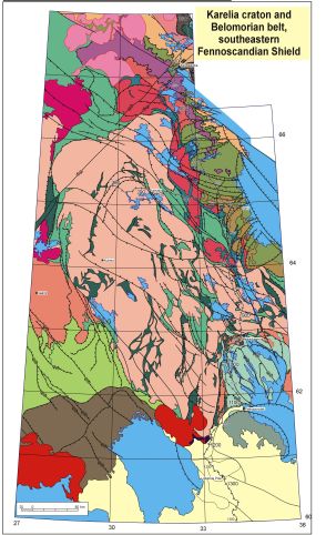
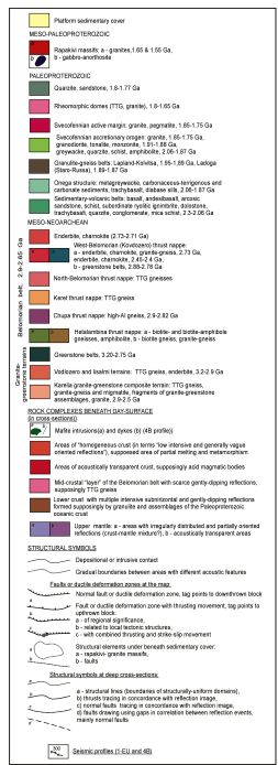
Fig. 2 – Geological map of the Karelia Craton and Belomorian Belt, southeast Fennoscandian Shield.
Archean granite-greenstone assemblages of the central and eastern parts of the Karelian Craton are transected by a series of the Paleoproterozoic volcano-sedimentary belts that are usually understood as synclinal folds built by "proto-platform" assemblages or as deformed strata of troughs and basins resulting from rifting episodes.
However, from deep seismic profiling images these parts of the Karelian Craton appear as imbricated crust built by alternating slices of Archean granite gneisses and Paleoproterozoic volcano sedimentary assemblages. Tectonic slices dip steeply northeastward, then flatten and partially unite at 20 km depth (Fig. 3). This depth can be interpreted as the main detachment at the base of the Paleoproterozoic succession. Correspondingly, the Paleoproterozoic linear belts are interpreted as the outcropping frontal parts of these slices (Fig. 4).
In turn, the Onega "depression" appears as an ensemble of gently dipping crustal slices thrust northwestward and tectonic slices of the Belomorian Belt thrust westward on top of Karelian Craton.
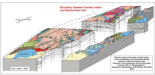
Fig. 3 – Three-dimensional image of the Earth's crust under the Fennoscandian Shield
showing the seismic reflection profiling images superimposed on the geological mapping image.
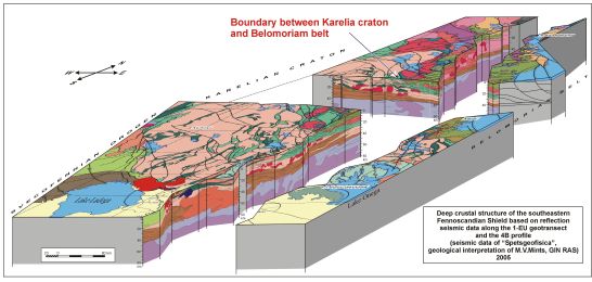
Fig. 4 – Three-dimensional image of the Earth's crust under the Fennoscandian Shield
showing the geological interpretation of the seismic reflection profiling images
superimposed on the geological mapping image.
The most prominent tectonic zone observed along the 4B cross-profile separates the Belomorian Belt from the Karelian Craton and Paleoproterozoic Shombozero Structure. The geometrical features of the seismic reflection image indicate that this zone is an overthrust-underthrust structure.
Tectonic sheets several hundred kilometers long formed from both Archean and Paleoproterozoic assemblages can be traced from the present-day surface down to the Moho discontinuity, where irregularly distributed and dipping reflection events continue the main trends in the crustal structure down to the mantle. Similar features are characteristic of places of bending and plunging down into the mantle of high-reflective low-crustal fragments along the Karelia-Svecofennian boundary, which suggests they are the remnants of Svecofennian oceanic lithosphere.
Careful coordination of mapped surface geological structures and geological interpretaion of the seismic images along both seismic cross-sections enabled a detailed interpretation of the 3-D model of the Earth's crust and upper part of lithospheric mantle in this region of the northwest East European Craton.
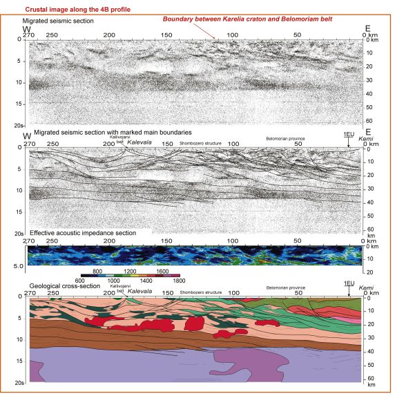
Fig. 5 – Deep seismic images of the Earth's crust along cross-traverse 4B (270 km)
near the White Sea (Left = West; Right = East).
Note the prominent decrease in reflectivity at the Moho at about 12 seconds two-way time (TWT) (~35km depth).
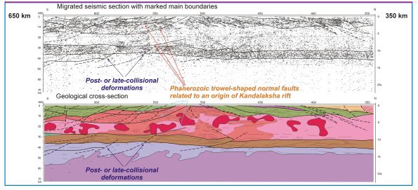
Fig. 6 – Deep seismic profiling image of the Earth's crust along the northern part of profile 1-EU (350 km to 650 km)
(Right =North; Left= South) (for location see Fig. 1).
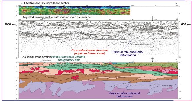
Fig. 7 – Deep seismic profiling image of the Earth's crust along the part of profile 1-EU, 650 km to 1000 km
(Right =North; Left= South) (for location see Fig. 1).
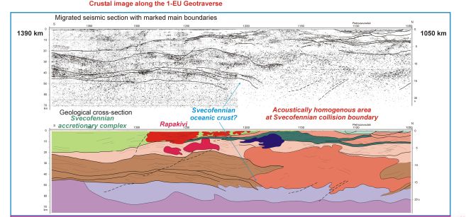
Fig. 8 – Deep seismic profiling image of the Earth's crust along the part of profile 1-EU, 1050 km to 1390 km
(Right =North; Left= South) (for location see Fig. 1).
Within the limits of the area studied, situated in the south-eastern part of the Fennoscandian Shield, the Karelian Craton and the Belomorian Tectonic Province are formed from Neoarchean lithosphere. They are separated by the North- and East-Karelian Paleoproterozoic sedimentary-volcanic belts that are linked within the Circum-Karelian Belt (Fig. 1).
The Karelian Craton is bordered to the south and the southwest by volcano-sedimentary rock assemblages forming structures of the Paleoproterozoic Svecofennian Accretionary Orogen. Meso- and Neoarchean rocks of the tonalite-trondhjemite-granodiorite series dominate within the granite gneiss formation of the Karelian Craton (the Karelian granite-greenstone terrain). These assemblages are thought to have formed under tectonic settings now prevailing at oceanic plateaus, island arcs, back- and forearc basins and passive margins. Paleoproterozoic granites are not widespread.
Like the Karelia Craton, the Belomorian Tectonic Province is suggested to be a segment of the Neoarchean supercontinent bounded by Paleoproterozoic sedimentary-volcanic belts that can be interpreted in some places as suture type structures: the Pechenga-Imandra-Varzuga Belt in the north, the North-Karelian and East-Karelian Belts in the south and south-west and the Karasjoki Belt in the north-west. Tectonic nappes of the Belomorian province consist of high-alumina gneisses and amphibolites of the Belomorian series, as well as of granite-greenstone associations that were considered previously as forming the basement to the Belomorides.
In contrast with the Karelian Craton, Paleoproterozoic granitoid magmatism within the limits of the Belomorian province is significantly more distributed, within the time interval from 2.45 Ga (microcline granites) to 1.8-1.65 Ga (mica pegmatites). The Karelian granite-greenstone terrain is crossed by a series of Paleoproterozoic sedimentary-volcanic belts striking NNE through its central and eastern parts at an acute angle with respect to the north-south strike of the Neoarchean greenstone belts.
It is usually assumed that the Karelian granite–greenstone terrain was cratonized at the end of the Neoarchean and overlain by the Paleoproterozoic sedimentary–volcanic "proto-cover" which is preserved within the limits of rift structures. Among these rift structures, as a first approximation, two types of syncline–shape structures stand out: 1) brachyform structures from some tens of kilometres to 300 km wide (the Shombozero, Lehta, Segozero and Onega structures), and 2) narrow linear structures up to 200 km long and 2-10 km wide. For the first type, a gentle dip is characteristic. For the second type of structures, rocks dip at an angle of 60–80°, vertical and overturned occurrences are rather typical. Frequent absence of one of the limbs transforms them into monoclines.
We suggest that evolution of the northeastern Fennoscandian Shield during the Paleoproterozoic evolved as follows (Mints & Konilov, 2004):
Mints M.V. and Konilov A.N., 2004. Geodynamic crustal evolution and long-lived supercontinents during the Palaeoproterozoic: evidence from granulite-gneiss belts, collisional and accretionary orogens. In - "The Precambrian Earth: Tempos and events", Developments in Precambrian Geology, 12, (Editors. - P. G. Eriksson, W. Altermann, D. R. Nelson, W. U. Mueller and O. Catuneanu), Elsevier Press, Amsterdam, Boston and elsewhere, 223-239.
Mints, M.V., Berzin, R.G., Suleimanov, A.K., Zamozhnyaya, N.G., Stupak, V.M., Konilov, A.N., Zlobin, V.L., and Kaulina T.V., 2004. The deep structure of the early Precambrian crust of the Karelian Craton, southeastern Fennoscandian Shield: results of investigations along CMP Profile 4B // Geotectonics, vol. 38, No. 2, 87-102. Translated from Geotektonika.
Mints, M.V., Berzin, R.G., Andryushchenko, Yu.A., Zamozhnyaya, N.G., Zlobin, V.L., Konilov, A.N., Stupak, V.M. and Suleimanov, A.K., 2004. The deep structure of the Karelian Craton along Geotraverse 1-EU // Geotectonics, vol. 38, No. 5, 329-342. Translated from Geotektonika.
Michael Mints
Geological Institute
Russian Academy of Science
Moscow
michael.mints@mtu-net.ru
1Geological Institute, Russian Academy of Science, Moscow, Russia, michael.mints@mtu-net.ru
2Spetsgeofisica, Povarovka, Moscow Region, Russia, eskp.sg@telcomnet.ru
[an error occurred while processing this directive]