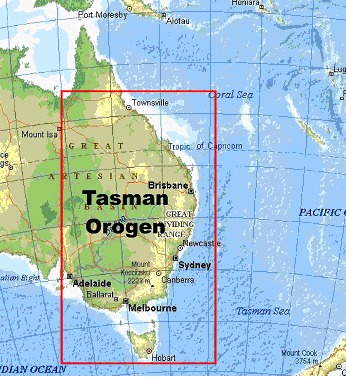
Fig. 1 – Eastern Australia and the Tasman Sea showing the location of the Tasman Orogen.
Updated: Dec 09, 2024
Compiled by Doug Finlayson
The Tasman Orogen of eastern Australia is represented in the basement rocks of about one third of the Australian landmass and elements of the orogen extend right along the eastern seaboard of Australia from southern Tasmania to north Queensland.
Fig. 1 – Eastern Australia and the Tasman Sea showing the location of the Tasman Orogen.
During the Early Palaeozoic - Early Mesozoic period the Australian land area increased in area by about 30% (Betts et al., 2002). At that time Australia was located on the eastern margin of the Gondwana super-continent that also included parts of present-day India, Antarctica, New Zealand, Africa and South America (Scotese, 1997) (Fig. 2).
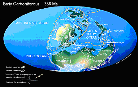
Fig. 2 – Paleo-reconstruction of land masses during Early Carboniferous times (356 Ma before present)
(Scotese, 1997, 2001). Note the location of Australia on the eastern margin of Gondwana.
The plate tectonic processes that led to this increase in the area of continental Australia are regarded as being similar to those currently operating in the Western Pacific with a succession of terranes being accreted to continental Australia (Gray & Foster, 2004). The boundary that separates eastern Australia from the Precambrian Australian craton to the west is termed the Tasman Line. Although obscured under later sedimentary sequences along much of its length and thus still much discussed, this line presents geophysical signatures (seismic, gravity, magnetic) that can now be used to more exactly define its location (Direen & Crawford, 2003; Kennett et al, 2004) down to depths in excess of 75km, much deeper than the crustal/mantle boundary (Moho) and well into the Earth's upper mantle.
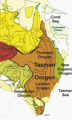
Fig. 3 – Tasman Orogen of eastern Australia showing component Delamerian, Lachlan,
Thomson, and New England Orogens and the Tasman Line.
The Tasman Orogen is regarded as having been formed by successive cratonisation from west to east of the Early Palaeozoic Delamerian Orogen (550-470Ma), the Middle Palaeozoic Lachlan and Thomson Orogens (450-340Ma) and the Late Palaeozoic to Early Mesozoic New England Orogen (310-210Ma) (Grey & Foster, 2004) (Fig. 3). Subsequently there has been a series of basin-forming processes operating across the whole region that have led to much of the basement rock being obscured by numerous Late Palaeozoic to Mesozoic sedimentary sequences.
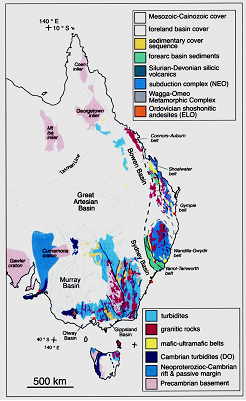
Fig. 3 – Outcrop rocks of the Tasman Orogen across eastern Australia (Gray & Foster, 2004).
The Tasman Orogen of eastern Australia is a well-preserved model of continental accretion and land mass addition. The tectonic processes involved in the creation of this landmass have resulted in the basement rocks of the orogen being a significant source of mineral wealth for Australia. Among many other mineral resources, the orogen hosts a number of world-class gold and base metal deposits.
The sedimentary basins that obscure much of the basement rocks have been the result of lithospheric processes applying across the region affecting these basement rocks and have created oil, gas and groundwater resources that are significant for regional Australian markets and coal resources that are important on world-wide markets.
World-wide analogues of the tectonic setting that resulted in the Tasman Orogen include:
In eastern Australia there have been a significant number of seismic surveys that have provided images of the Earth's crust. Wide-angle seismic velocity profiling has defined seismic velocities within the crust and upper mantle and deep seismic reflection profiling has imaged geological structure in many parts of eastern Australia. In addition, the analysis of seismic energy from earthquakes recorded at numerous temporary broad-band seismic stations has provided valuable information on crustal thickness (depth to the Moho) and also features deep within the underlying mantle.
P-wave seismic velocities within the Earth's crust of eastern Australia are well defined in some areas. Wide-angle seismic profiling has shown there to be significant differences not only in the velocities within the crust but also in the depth to the crust-mantle boundary (Moho). The depth to the Moho has also been defined by analysing receiver functions of earthquake-generated seismic waves recorded at broad-band seismic stations distributed across eastern Australia (Collins, 2003; Shibutani et al., 1996).
Figures 4 a) and b) show respectively the thickness of the Earth's crust under eastern Australia and examples of the velocity-depth profiles for P-waves at some locations.
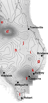
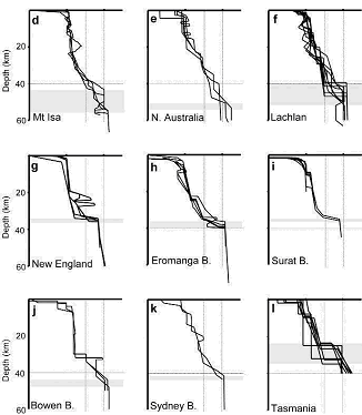
Fig. 4 – a) Variation in depth to the Moho under eastern Australia and the locations of wide-angle seismic profiles illustrated in Fig 4b , and
b) velocity-depth profiles of P-wave velocities under the areas of eastern Australia indicated in Fig. 4a (Collins et al., 2003).
The differences in the seismic wave speeds deep into the lithosphere under Australia have been desribed by Kennett (2003). There are significant differences between eastern Australia and the western Precambrian continent to depths in excess of 200 km. Figure 5 shows the perturbation in shear-wave speed at 140 km depth. The differences in wave-speed are attributed to a combination of thermal and chemical variability across the continent.
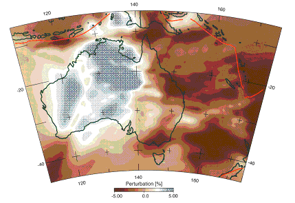
Fig. 5 – Variation in shear-wave speed across continental Australia at 140 km depth.
The neutral (white) tone is set at 4.6 km/s (Kennett, 2003).
Note the significant difference between eastern and western continental Australia.
There are numerous deep seismic profiling lines across the Tasman Orogen. In this summary paper, examples of images are taken from four locations to illustrate the data available and the nature of some of the structures important in the development of the Tasman Orogen. Figure 6 shows the location of the five data sets summarised below.
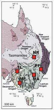
Fig. 6 – Map of the major structures of the Tasman Orogen showing the five locations
of deep seismic profiling data summarised below.
QT = Quilpie Trough; PF = Peel Fault; MA = Macquarie Arc;
MF = Moyston Fault;
TL - Tasman Line (Broken Hill) (derived from Gray & Foster, 2004).
In the Lachlan Orogen of the eastern Tasman Orogen, there are remnants of the Ordovician Macquarie Arc that are host to some world-class gold deposits and other mineral systems. Deep seismic reflection profiling and wide-angle seismic profiling have provided images of the structural features of the deep geology across the region. The Macquarie Arc was subsequently rifted during Silurian-Devonian times with the Ordovician volcanics preserved under younger troughs and shelves (Glen et al., 2002). Figures 7 and 8 show some of the structural features of the western Macquarie Arc down to depths of about 18 km.
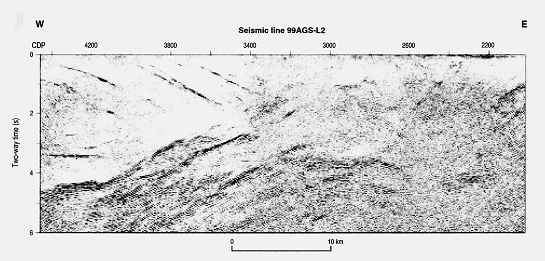
Fig. 7 – Deep seismic reflection image from the western Macquarie Arc (central Tasman Orogen)
down to 6 seconds two-way time (depths of about 18 km) (Glen et al., 2002).
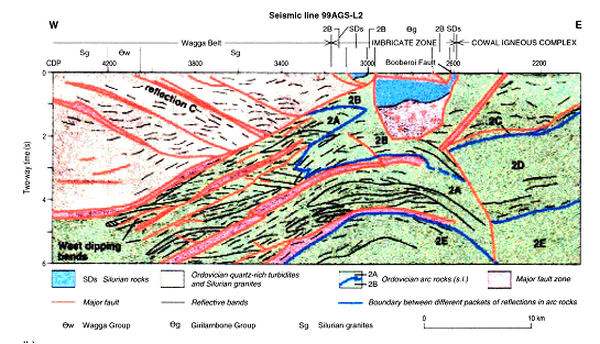
Fig. 8 – Interpreted geology from the seismic image from the western Macquarie Arc
(central Tasman Orogen)
down to depths of about 18 km (Glen et al., 2002).
The northern part of the Tasman Orogen is referred to as the Thomson Orogen, mostly in Queensland (Murray & Kirkegaard, 1978). Basement rocks are largely obscured by the Eromanga and Surat Basins and underlying basin sequences that have been extensively explored for oil and gas resources. In addition there have been many long deep seismic profiles across the region, most notably along the Eromanga Brisbane Geoscience Transect (Finlayson, 1990; Finlayson et al., 1990; Leven et al., 1990). This 1100 km long deep seismic profile extended from central Queensland to the coast near Brisbane (Fig. 9). The deep seismic reflection profiling was supplemented with wide-angle seismic profiling that gave P-wave velocity information for the crust and upper mantle in the region.
Fig. 9 – Location of the 1100 km long Eromanga-Brisbane Geoscience
deep seismic
profiling transect across southern Queensland.
The Nebine Ridge is a basement high separating the Eromanga and Surat Basins and Thomson Orogen rocks outcrop on the ridge north of the Eromanga-Brisbane Transect. Figures 10 and 11 show examples of seismic data from a small part of the whole deep seismic transect together with velocity information across the Nebine Ridge. The seismic data has been reprocessed in recent years to image the deep crust more effectively (Finlayson et al., 2004). Even features within the upper mantle are now imaged quite clearly.
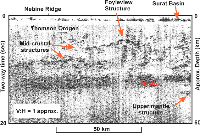
Fig. 10 – Seismic image of the crust under the Nebine Ridge between the Eromanga
and
Surat Basins
in the northern part of the Tasman Orogen (Finlayson et al., 1990).
Note the well-defined band of reflections from the Moho and mid-crustal structures.
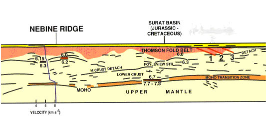
Fig. 11 – Sketch of P-wave velocity structure of the crust and upper mantle
under the Nebine Ridge (Finlayson et al., 1990).
The western margin of the Lachlan Orogen (southern part of the Tasman Orogen) outcrops in the region of the Grampian Mountains of western Victoria. Deep seismic reflection profiling has revealed the nature of faulting in the region. The boundary between the Lachlan Orogen and the Delamerian Orogen to the west is taken to be the Moyston Fault. This east dipping fault is consistent with recent field mapping and gives weight to plate tectonic reconstructions of the southern part of the Tasman Orogen (Korsch et al., 2002; Gray & Foster, 2004) (Figs 12 & 13).
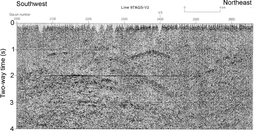
Fig. 12 – Deep seismic reflection profile across the Moyston Fault in the Grampian Mountain region
of the Lachlan Orogen (Gray & Foster, 2004).
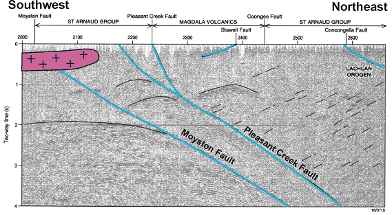
Fig. 13 – Deep geological interpretation of seismic profile 97AGS-V2
across the Moyston Fault (Gray & Foster, 2004).
The New England Orogen of eastern Australia is that part of the Tasman Orogen to the east of the Bowen-Gunnedah-Sydney Basin system and the Thomson and Lachlan Orogens. During Devonian and Carboniferous times the development of eastern Australia was dominated by a convergent plate margin with west dipping subduction taking place. An accretionary wedge formed the main part of the New England Orogen and the present-day Tamworth and Yarrol Belts correspond to the forearc basin (Korsch et al., 1997). The volcanic arc is now no longer apparent being either missing, removed by erosion or strike-slip faulting or concealed beneath the Tamworth Belt or Gunnedah Basin.
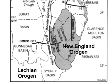
Fig. 14 – Location of deep seismic profile from the Lachlan Orogen
to the New England Orogen across the Peel Fault.
The northern part of the Tamworth Belt forearc sequences were involved in oroclinal bending and consequent widening of the New England Orogen in that area (Korsch & Harrington, 1987) (Fig. 15).
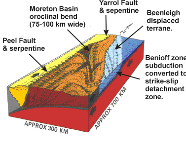
Fig. 15 – Oroclinal bending model for the New England Orogen (Korsh & Harrington, 1987).
The crustal architecture across the Peel Fault and Tamworth Belt between the New England and the Lachlan Orogens provides a model for preserved structures across a convergent margin. An east-west deep seismic profile across the bounding faults of the New England Orogen and the Tamworth Belt during 1991 provide images across these structures (Fig. 16a & 16b) (see Figure 14 for location).
The depth to the Moho under the New England Orogen is known from wide-angle seismic profiling (34-35 km) summarised in Figure 4 (Finlayson & Collins, 1993).
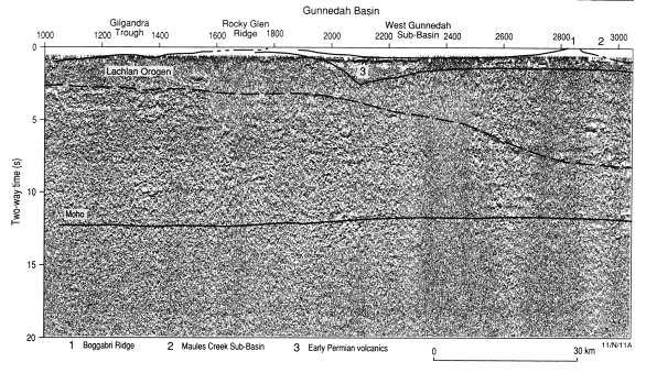
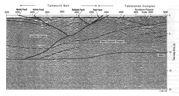
Fig. 16 – Deep seismic reflection profile across the Gunnedah Basin, Tamworth Belt
and Peel Fault onto the New England Orogen (Tablelands Complex)
a) western section, b) eastern section (Korsch et al., 1997).
Interpretation of the seismic data indicates that the accretionary wedge part of the New England Orogen is thrust beneath the easternmost Lachlan Orogen but that the forearc basin (Tamworth Belt) is obducted (backthrust) on top of the Lachlan Orogen (Korsch et al., 1997) (Fig. 17).
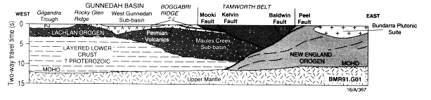
Fig. 17 – Interpretation diagram of structures across the boundary between
the New England Orogen
and the Lachlan Orogen (Korsch et al., 1997).
The Tasman Line is defined as the boundary between outcrops of Precambrian crustal elements to the west and Palaeozoic crustal elements to the east. It separates the older Broken Hill Block from the younger Lachlan Orogen. In the Broken Hill region it is marked by NE-SW trending gravity and magnetic anomalies (Leven et al., 1998) (Fig. 18). The Tasman line in this region is considered to be the location of a rifting of the Rodinia super-continent when the South China Block separated from Precambrian Australia at about 750 Ma (Powell, 1998) .
During 1997 both seismic reflection and wide angle profiling data were recorded across the Tasman Line in the Broken Hill region (Fig. 18).
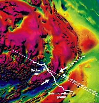
Fig. 18 – Magnetic image of the Broken Hill region showing
the location of the Tasman Line and seismic profiling ( Leven et al., 1998).
Interpretation of the wide-angle seismic data indicates that the upper crust beneath the Broken Hill Block thickens but the lower crust with a P-wave velocity of 6.9-7.1 km/s is relatively constant in thickness along the profile. There is a region of lower crustal velocities beneath the Menindee Trough and the Blantyre Trough to the southeast (Fig. 19) (Leven et al., 1998).
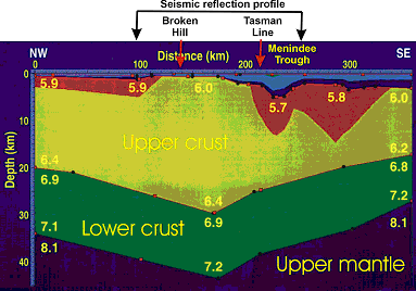
Fig. 19 – Seismic velocity model of the Earth's crust across the Tasman Line (Leven et al., 1998).
The most prominent feature on the reflection sesmic data across the Broken Hill Block is the southeast dipping reflection horizons (Fig. 20). These have been interpreted as shear zones. Some events can be directly correlated with particular surface-mapped features such as the Mundi-Mundi Fault (Leven et al., 1998).
The most significant outcome of the seismic reflection profiling is that several major shear zones were imaged, the majority of which dip southeast. Some of these shear zones penetrate through the whole crust while others extend to the middle crust only (Fig. 21). Given the depth of penetration, many shear zones may have conducted mineral-rich fluids from deep to shallow depths and be important conduits during the formation of ore bodies. Some of these shear zones may have formed during the break-up of Rodinia in the Late Proterozoic (Fomin et al., 1998).
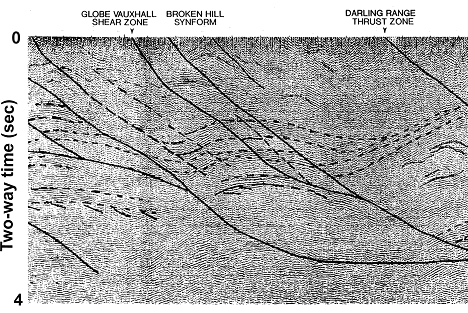
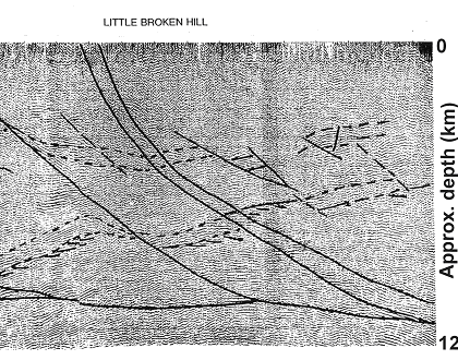
Fig. 20 – Example of deep seismic reflection profiling data to 4 seconds two-way time (about 12 km depth)
in the Broken Hill region and interpreted structural features (Gibson et al., 1998).
It should be noted that fission track data and metamorphic grade suggest that about 15 km of material has been eroded from the Broken Hill Block to expose the current rocks at the surface. Thus it is possible that the Earth's crust in the region was 55-60 km thick during early orogenic episodes and tectonic stacking of thin crust (Drummond et al., 1998).
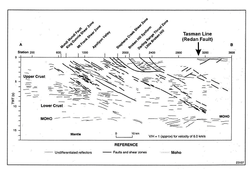
Fig. 21 – Line diagram of seismic reflection data across the Broken Hill Block
and Tasman Line together with interpreted shear zones and other structural features (Fomin et al., 1999).
Crawford et al. (2003) contend that the geological history of south-eastern Australia between the Late Neoproterozoic (ca 600 Ma) and the Early Ordovician (ca 490 Ma) records a cycle of continental rifting and ocean opening (ca 600 Ma), subduction (starting ca 515 Ma), and arc-continent collision, with important post-collisional extension, magmatism (500 Ma), exhumation of underthrust Neoproterozoic continental crust, and molasses deposition. The dimensions, orientation and duration of these events bear a striking similarity to events east of Australia from 100 Ma until the present (Fig. 22) and argue for very similar processes having affected the eastern margin of Australia from 600 Ma until the present (Crawford et al., 3003).
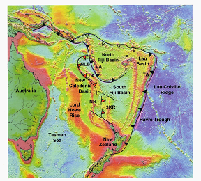
Fig. 22 – Southwest pacific gravity anomalies derived from satellite altimetry showing
the major morphotectonics elements. These elements and the tectonic processes currently acting
across the region are regarded as being similar to those acting across eastern Gondwana
during Late Neoproterozoic to Early Ordovician times (ca 600-220 Ma) (Crawford et al., 2003).
Crawford et al. (2003) indicate that the southwest Pacific style of crustal growth above a rolling-back tectonic slab during the period 600-220 Ma explains key aspects of the geological evolution of eastern Australia (Fig. 22). A subduction system east of Gondwana produced the Macquarie Arc (oldest lavas ca 480 Ma) and slab roll-back induced regional extension and the narrow linear troughs of the Macquarie Arc. This persisted until the terminal deformation of the orogen in the late-Middle to Late Devonian. Crawford et al. (2003) envisage a similar process generating the New England Orogen between the Late Devonian and Late Triassic. During the post-120 Ma breakup of eastern Australia that resulted in the Tasman Sea opening, elements of the New England Orogen moved oceanward to New Zealand, the Lord Howe Rise and the Norfolk-New Caledonia Rise.
Gray & Foster (2004) summarise much of the early work on tectonic models for eastern Australia where analogues are drawn from current northwest Pacific, Japan-Philippines region tectonic systems (Fig. 23).
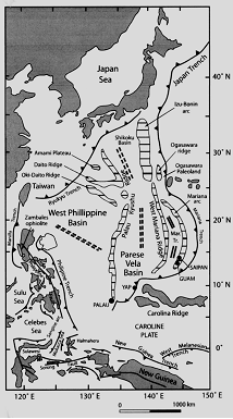
Fig. 23 – The processes acting on the terranes of the western Pacific are regarded as
analogues of the processes acting on eastern Australia during Palaeozoic times (Gray & Foster, 2004).
In the northwest Pacific setting marginal seas such as the Philippines Sea are currently involved in multiple subduction environments dominated by oceanic crust but with small embedded continental fragments as well as remnant volcanic arcs. The Japan Sea backarc basin dominated by extended and attenuated continental crust is also envisaged as an appropriate model.
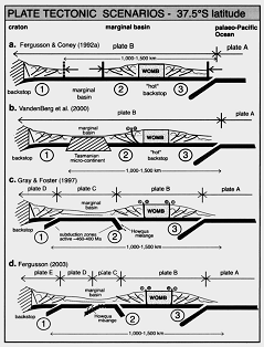
Fig. 24 – Summary of the crustal plate tectonic models envisaged for the Lachlan Orogen of eastern Australia
during Palaeozoic times (Gray & Foster, 2004).
WOMB = Wagga-Omeo Metamorphic Belt.
The circled numbers 1, 2 and 3 indictae the locations of the three thrust systems
that operated to produce the Lachlan Orogen crustal architecture.
In more recent work Gray & Foster (2004) indicate that more complex scenarios have evolved involving multiple subduction systems in a marginal ocean setting behind a major long-lived subduction system. However, in order to explain the major thrust systems and other features of the Lachlan Orogen, Gray & Foster (1997) proposed a short-lived, complex west-Pacific type setting on eastern Gondwana from ca 460 Ma to 380 Ma. Plate tectonic scenarios for the mid-Silurian (ca 430 Ma) for the southern Lachlan Orogen at present-day latitude 37.5 deg. S are shown in Figure 24.
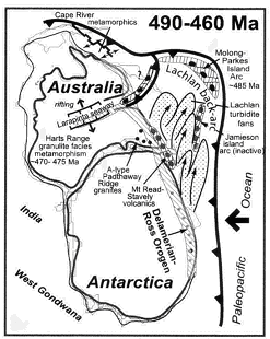
Fig. 25 – Speculative Early to Middle Ordovician (ca. 490-460 Ma) tectonic setting for
the Tasman Orogen
on the eastern margin of Gondwana (Gray & Foster, 2004).
Serrated thick line indicates the location of a subduction zone thought to have been active
to the east of Australia for most of the time during which the Tasman Orogen was being formed.
The compiler of this brief description freely acknowledges the original research work by the authors of the papers referred to in the text and figure captions and of the publishers. Text passages quoted and figures used from these papers are made within the "fair dealing" and the "fair use" provisions for "research and study" and for "criticism and review" within the copyright laws of Australia, other common law jurisdictions, countries of the European Union and the USA. Any copyright issues arising from this web page should be brought to the attention of Dr. D. M. Finlayson (doug.finlayson@netspeed.com.au ), Business Manager, IGCP Project 474.
Betts, P. G., Giles, D., Lister, G. S., & Frick, L. R., 2002. Evolution of the Australian lithosphere. Australian Journal of Earth Sciences, 49, 661-695.
Collins, C. D. N., Drummond, B. J. & Nicoll, M. G., 2003. Crustal thickness patterns in the Australian continent. Geological Society of Australia Special Publication 22 and Geological Society of America Special Paper 372, 121-128
Crawford, A. J., Meffre, S., & Symonds, P. A., 2003. 120 to 0 Ma tectonic evolution of the southwest Pacific and analogous geological evolution of the 600 to 220 Ma Tasman Fold Belt system. Geological Society of Australia Special Publication 22 and Geological Society of America Special Paper 372, 383-403.
Direen, N. G., & Crawford, A. J., 2003. The Tasman Line: where is it, what is it, and is it Australia's Rodinian breakup boundary? Australian Journal of Earth Sciences, 50, 491-502.
Drummond, B. J., Fomin, T. & Leven, J. H., 1998. Constraints on structure and composition of the Broken Hill region from seismic reflection and refration studies. Australian Geological Survey Organisation Record 1998/25, 21-26.
Finlayson, D. M., 1990. The Eromanga - Brisbane Geoscience Transect; a guide to basin development across Phanerozoic Australia in southern Queensland. Bureau of Mineral Resources, Geology and Geophysics, Australia, Bulletin 232.
Finlayson, D. M., Wake-Dyster, K. D., Leven, J. H., Johnstone, D. W., Murray, C. G., Harrington, H. J., Korsch, R. J., & Wellman, P., 1990. Seismic imaging of major tectonic features in the crust of Phanerozoic eastern Australia. Tectonophysics, 173, 211-230.
Finlayson, D. M. & Collins, C. D. N., 1993. Lithospheric velocity structures under the southern New England Orogen: evidence for underplating at the Tasman Sea margin. Australian Journal of Earth Sciences, 40, 141-153.
Finlayson, D. M., Murray, C. G., Johnstone, D. W. Chudyk, E. C. Korsch, R. J., Barton, T. J., & Drummond, B. J., 2004. The Earth's crust across Phanerozoic Australia - a classic continental accretion and evolution model along the 1100 km deep seismic transect in southern Queensland. Abstracts of the 11th International Symposium on Deep Structure of the Continentas and their Margins, Mont-Tremblant, Canada, Canadian Geophysical Union, Geological Survey of Canada, 36-38.
Fomin, T., Gibson, G., Owen, A., Drummond, B., Wake-Dyster, K., & Maidment, D., 1998. Deep seismic profiling in the Broken Hill region: implications foe structural geology in the Willyama Supergroup. Geological Society of Australia Abstracts 49, 150.
Fomin, T., Drummond, B. J., & Leven, J., 1999. Seismic reflection and refration studies in the Broken Hill region. Minfo; New South wales Mining and Exploratory Quartely, 62, 26-28.
Gibson, G., Drummond, B., Fomin, T., Owen, A., Maidment, D., Gibson, D., Peljo, M., & Wake-Dyster, K., 1998. Re-evaluation of crustal structure of the Broken Hill Inlier through structural mapping and seismic profiling. Australian Geological Survey organisation Record 1998/11.
Glen, R. A., Korsch, R. J., Direen, N. G., Jones, L. E. A., Johnstone, D. W., Lawrie, K. C., Finlayson, D. M., & Shaw, R. D., 2002. Crustal structure of the Ordovician Macquarie Arc, eastern Lachlan Orogen, based on seismic reflection profiling. Australian Journal of Earth Sciences, 49., 323-348.
Gray, D. R. & Foster, D. A., 1997. Orogenic concepts - application and definition: Lachlan Fold Belt, eastern Australia. American Journal of Science, 297, 859-891.
Gray, D. R. & Foster, D. A., 2004. Tectonic evolution of the Lachlan Orogen, southeast Australia: historical review, data synthesis and modern perspectives. Australian Journal of Earth Sciences, 51, 773-817.
Kennett, B. L. N., 2003. Seismic structure in the mantle beneath Australia. Geological Society of Australia Special Publication 22 and Geological Society of America Special Paper 372, 7-23.
Kennett, B. L. N., Fishwick, S., Reading, A. M., & Rawlinson, N., 2004. Contrasts in mantle structure beneath Australia: relation to Tasman Lines? Australian Journal of Earth Sciences, 51, 563-569.
Korsch, R. J., Johstone, D. W., & Wake-Dyster, K. D., 1997. Crustal architecture of the New England Orogen based on deep seismic reflection profiling. In: Tectonic and Metallogenesis of the New England Orogen, Geological Society of Australia Special Publication 19, 29-51.
Korsch, R. J., & Harrington, H. J., 1987. Oroclinal bending, fragmentation and deformation of terranes in the New England Orogen, eastern Australia. American Geophysical Union Geodynamics Series 19, 129-139.
Leven, J. H., Finlayson, D. M. & Wake-Dyster, K., 1990. Mid-crustal detachments controlling basin deformation: ramp synforms in southwest Queensland. Tectonophysics, 173, 231-246.
Leven, J. H., Fomin, T., Owen, A., Johnstone, D. W., Drummond, B. J., Wake-Dyster, K. D., & Finlayson, D. M., 1998. The nature of the Tasman Line southeast of the Broken Hill Block. Geological Society of Australia Abstracts 49, 270.
Murray, C. G., & Kirkegaard, A. G., 1978. - The Thomson Orogen of the Tasman Orogenic Zone. Tectonophysics, 48, 299-325.
Scotese, C. R., 1997. Paleogeographic Atlas, PALEOMAP Progress Report 90-0497, Department of Geology, University of Texas at Arlington, Arlington, Texas, 37 pp.
Scotese, C. R., 2001. - Atlas of Earth History. Department of Geology, University of Texas, Arlington Texas, USA.
Shibutani, T., Sambridge, M. & Kennett, B., 1996. - Generic algorithm inversion for receiver functions with application to crust and uppermost mantle structure beneath Eastern Australia. Geophysical Research Letters, 23, 1829-1832.
Bruce Goleby, Geoscience Australia, GPO Box 378, Canberra ACT 2601, Australia.
Russell Korsch, Geoscience Australia, GPO Box 378, Canberra ACT 2601, Australia.
Tim Barton, Geoscience Australia, GPO Box 378, Canberra ACT 2601, Australia.
Leonne Jones, Geoscience Australia, GPO Box 378, Canberra ACT 2601, Australia.
Clive Collins, Geoscience Australia, GPO Box 378, Canberra ACT 2601, Australia.
Barry Drummond, Geoscience Australia, GPO Box 378, Canberra ACT 2601, Australia.
David Gray, School of Earth Sciences, University of Melbourne, Vic. 3010, Australia.
Cec Murray, Geological Survey of Queensland, GPO Box 194, Brisbane Qld. 4001 Australia.
Dick Glen, Geological Survey of New South Wales, PO Box 344, Hunter Region Mail Centre, NSW 2310, Australia.
Doug Finlayson, 6 Neilson St., Garran ACT 2605, Australia
[an error occurred while processing this directive]