[an error occurred while processing this directive]
[an error occurred while processing this directive]
Updated:
IGCP Project 559 - Seismic Images
DRUM (Deep Reflections from the Upper Mantle) off the north coast of Scotland

Compiled by Richard Hobbs
Department of Earth Sciences, University of Durham
South Road, Durham
DH1 3LE, UK
Introduction
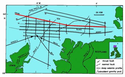
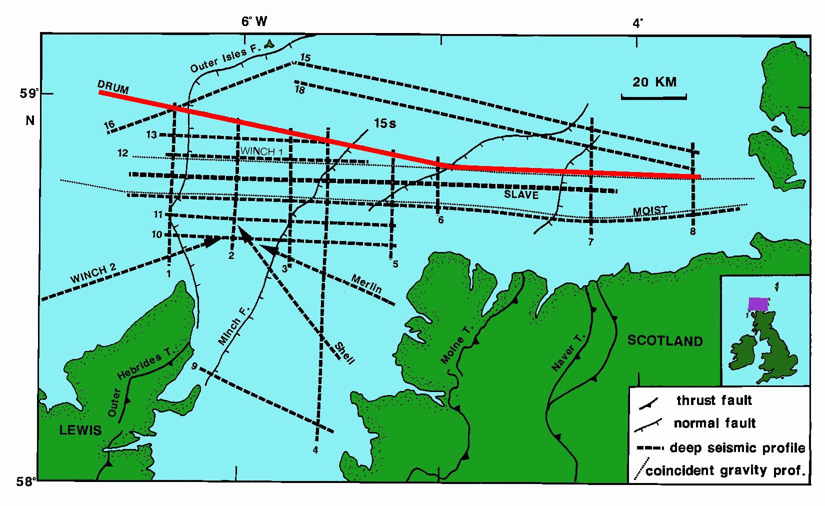
Figure 1: Map of deep seismic profiles acquired off the north coast of Scotland
with the location of the DRUM profile highlighted in red. (MOIST, WINCH, GRID (numbers 1-13,15,16,18)
and SLAVE are BIRPS profiles. [view large image - JPG 233kB]
The DRUM profile is arguably the most famous deep seismic reflection profile worldwide. It was acquired in 1984 and shows how the continetal crust responds to a sequence of tectonic events. With a recording length of 30s, DRUM was the first reflection profile to show extensive reflectivity from the upper mantle. The image of discrete sub-Mohorovicic Discontinuity reflectivity, the Flannan and W-reflectors, at once demonstrated structural complexity and heterogeneity in the sub-crustal mantle that has completely changed our view of the role of the mantle in lithospheric evolution.
Summary of results
Summaries of the results from the profile are given in Klemperer & Hobbs (1991).
In 1981, British scientists formed BIRPS (British Institutions' Reflection Profiling Syndicate) in a conscious effort to follow the lead of the COCORP program in the USA that was pioneering large-scale deep multi-channel seismic profiling of the continents. There was one important difference: under the influence of the UK hydrocarbon industry, focused offshore in the North Sea, the profiles were to be recorded at sea: the coastline is largely an accident of modern sea-level, and continental crust continues far offshore. The first profile (MOIST) acquired in 1981 was intended to image the deep structure of the Moine Thrust, the compressional structure in the Scottish Highlands where geologists had first recognized thrust faults 100 years earlier, and subsequently identified as one of the principal structures involved in the closing of oceans that had preceded the Atlantic over 400 million years ago, suturing together fragments of the North American and European continents. The Moine Thrust was indeed imaged, down to about 15km depth in the mid-crust. But the real surprise came twice as deep, below the Mohorovicic Discontinuity ("Moho", boundary between the crust and the mantle). Reflections dipping 30° to the east, sub-parallel to the Moine Thrust and related crustal faults, were clearly visible. Subsequent acquisition (WINCH and DRUM) shows these reflections continuing to at least c. 80km (50 miles) depth. Major crustal shortening and later extension is interpreted across the dipping faults within the crust, so the new dipping reflector, named "Flannan" for a group of nearby islands, was interpreted as a fault that had taken up corresponding tectonic movement in the mantle. A second reflector, named "W" observed sub-parallel to the Moho but at 45km depth east of the Flannan, is interpreted as part of the crustal shortening caused during the suturing event.
Just as COCORP results had astonished geologists worldwide in the mid-1970's with the detailed reflectivity of the continental crust, now BIRPS had discovered the first reflectors in the upper mantle in continental lithosphere imaged by near-normal incidence profiling. Complexity of the mantle was well-known at modern subduction zones, but was essentially ignored, for lack of data, beneath the continents. The Flannan reflector at once demonstrated structural complexity and heterogeneity in the sub-crustal mantle that has completely changed our view of the role of the mantle in lithospheric evolution. In the twenty years following their discovery, the Flannan and W reflectors were intensively mapped in three dimensions by a grid of profiles covering 10,000km2 (GRID and SLAVE); tracked along-strike for several hundred kilometers; and had their detailed physical properties carefully studied to demonstrate that they probably caused by a slab a few kilometers thick, relics of oceanic crust that remained within the lithosphere and were metamorphosed to eclogite when subduction halted. Other such intra-mantle structures are now widely recognized worldwide, and most are similarly interpreted to be relicts of ancient subduction zones. Some of the more spectacular examples are known from later BIRPS profiling in the Gulf of Bothnia between Sweden and Finland; and from Lithoprobe onshore multi-channel profiling in the Canadian Northwest Territories. These profiles cross the relics of two different 1900 million-year old collisional orogens in areas that have remained largely undisturbed since. The existence of subduction-related structures of this age seems clear proof of the antiquity of plate tectonics, and demonstrates that the present is key to at least the second half of Earth history.
An annotated DRUM profile can be viewed here [PDF 301kB]. This annotated seismic section shows near surface half-graben basins, several famous crustal features including the Outer Isles Fault and Moine Thrust Faults, reflectivity within the lower crust, a discrete Mohorovicic Discontinuity reflectivity, the mantle Flannan and W-reflectors. The DRUM section completely changed geologists view of the role of the mantle in lithospheric evolution.
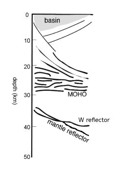
This figure shows a cartoon of the major features seen on the DRUM profile modified from an original cartoon by Drum Matthews. In the upper crust are a series of half-graben basins with mesozoic sediments dipping to the west truncated by east-dipping normal faults. These faults sole out into a zone of higher reflectivity in the lower crust off-setting it in some places. The lower crust reflectivity is abruptly truncated by the Moho at about 28-29km depth. Beneath the Moho are two bands of reflectivity in the upper mantle. One band emerges from the Moho at the western end of the profile then dips eastwards and can be traced to over 28s (~80km) travel-time, this is known as the Flannan reflector. The second band is sub-horizontal and only exists to the east of the Flannan reflector at a travel time of about 14s (~45km), this is called the W-reflector.
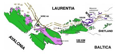
Subsequent profiling by the BIRPS programme and some industry data shows that the upper mantle reflectivity can be traced along the northwest margin of Britain. This map shows the restoration of late Caledonian age strike-slip deformations within northern Scotland (from Snyder et al. 1997). Contours and isolated numbers mark the depth in kilometres to the W-reflector as derived from various BIRPS profiles and modelling of the LISP-B refraction profile (Barton 1992). Purple colour shows the mapped extent of the late Precambrian age Dalradian rocks along the palinspastically restored margin of Laurentia (Hutton & Alsop 1996). The GGF (Great Glen fault) HBF (Highland Border fault) and FCL (Clew Bay Fair Head line) are all major Caledonian tectonic zones. These structures, the mantle reflector and the Dalradian rocks all parallel the reconstructed continental margin of Laurentia. The WTR (Wyville Thompson Ridge), FSB (Faroe Shetland Basin) and WOB (West Orkney Basin) are all structures thought related to the opening of the North Atlantic.
Research
The DRUM profile forms part of a network of deep seismic reflection profiles acquired by the BIRPS programme and a number of other profiles acquired by the hydrocarbons industry:
- MOIST, 1981
- the first BIRPS profile, showed the potential for offshore data acquisition for deep imaging of the lithosphere, it also showed evidence for sub-Moho reflectivity.
- WINCH, 1982
- confirmed the presence of sub-Moho reflectors
- DRUM, 1984
- the first profile recorded to 30s travel-time (~110 km depth)
- GRID, 1986
- profiles 1-13, 15, 16 & 18, provided 3-D mapping of the mantle reflections
- SLAVE, 1987
- a 2-ship experiment to improve velocity constraint on deep reflections
A review of research associated with the BIRPS programme can be found in 2 publications:
- The BIRPS Atlas (Klemperer and Hobbs 1991), Cambridge University Press,
- The BIRPS Atlas II (Snyder and Hobbs 1999), Geological Society Publications,
Other deep seismic data include Shell profile from the SW84 survey, and Merlin profile from the MP852 survey (see www.ukdeal.co.uk for comprehensive list of commercial data in area)
Other work in the region related to lithospheric imaging around north-west Scotland include:
Images of Seismic Data
Images and data can be downloaded as follows:
Data Acquisition
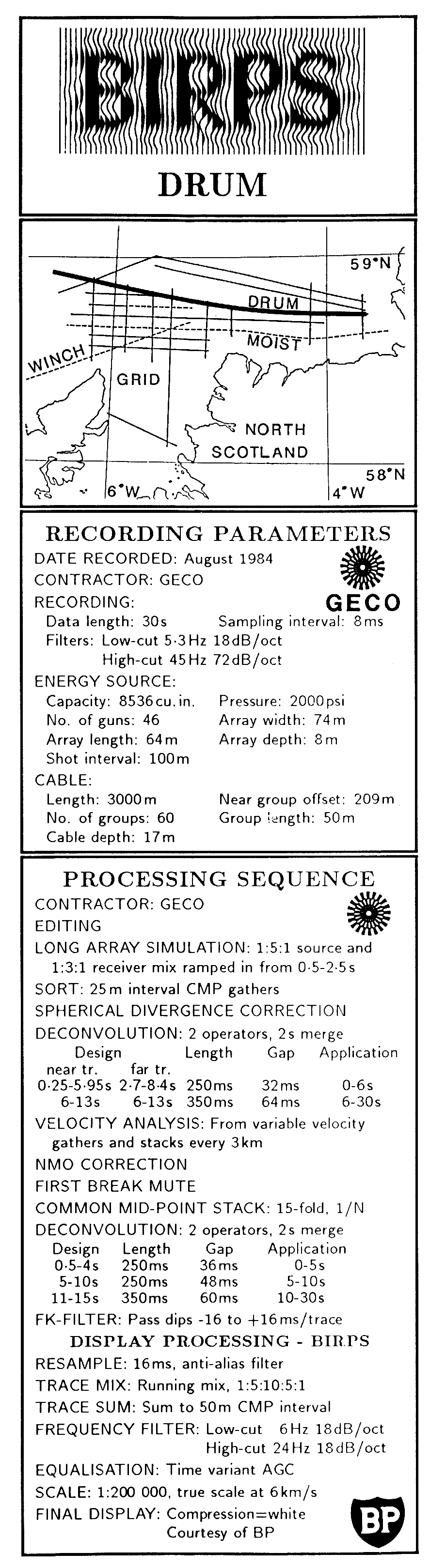
The profile was acquired in 1984 following earlier BIRPS acquisition in the area (MOIST in 1981 and WINCH in 1982) which had shown indications of reflectivity below the Moho.
| Year Shot & Contractor |
1984, GECO (now WesternGeco) |
|---|
| Type |
marine |
|---|
| Shot in 3 sections |
DRUM sp 101- 593
DRUM-A sp 1576-2580
DRUM-B sp 3563-3884
for each section the shotpoint number were incremented by 1000 and included overlap to ensure continuous coverage |
|---|
| Source |
airgun array |
|---|
| Volume |
8536 cu in |
|---|
| Operating pressure |
2000 psi |
|---|
| Shotpoint interval |
100m |
|---|
| Source depth |
8m |
|---|
| Receiver |
hyrophone |
|---|
| Number groups |
60 |
|---|
| Group interval |
50m |
|---|
| Receiver depth |
15m |
|---|
| Near offset |
209m |
|---|
| Recording |
DFS V |
|---|
| Record length |
30s |
|---|
| Sample interval |
8ms |
|---|
| Filters low cut |
5.3Hz (18dB/oct) |
|---|
| Filters high cut |
45Hz (72dB/oct) |
|---|
Data Processing
| Contractor | GECO (now WesternGeco) |
|---|
| Geometry | CMP bin 25 m |
|---|
| Source array simulation | 1-5-1 weighted trace mix |
|---|
| Receiver array simulation | 1-3-1 weighted trace mix |
|---|
| Divergence correction | |
|---|
| Predictive deconvolution | 2 operators with 2s overlap |
|---|
| Velocty analysis | ever 3 km |
|---|
| NMO correction | |
|---|
| Mute | |
|---|
| Stack fold | 15 |
|---|
| Predictive Deconvolution | 2 operators with 2s overlap |
|---|
| FK noise filter | +/-16 ms/trace |
|---|
| Time varient bandpass filter | |
|---|
| Time varient equalization | |
|---|
| Static correction +15 ms | |
|---|
| Coherency filter | weighted mix and semblance based mix (Milkereit & Spencer, 1990) have been applied to data for display on this web-site to enhance reflection events on small-scale displays. |
|---|

Annotated side label from the BIRPS Atlas (Klemperer and Hobbs 1991) can be downloaded (gif 173kB).
The images of seismic data on this web-site were resampled to 16ms and binned to a 50m CMP interval and had some additional processing for display at small scale.
Navigation
Navigation files for the DRUM profile can be downloaded from here or in decimated form from here.
Data Availabilty
Sub-sampled data (16ms sample interval, 50m CMP bin) is available on CD as part of the BIRPS Atlas II publication (Snyder & Hobbs 1999)
For copies of digital data and other metadata (navigation, stacked data, shot data, paper records, grav/mag)
Deep Geology Enquiries, British Geological Survey, Keyworth, Nottingham NG12 5GG, UK (or through their web site: www.bgs.ac.uk)
Navigation data can be downloaded as follows:
References
Asencio, E., Knapp, J. H., Owens, T. J., & Helffrich, G., 2003. Mapping fine-scale heterogeneities within the continental mantle lithosphere beneath Scotland: Combining active- and passive-source seismology. Geology, 31, 477-480.
Barton, P. J., 1992. LISPB Revisited: A new look under the Caledonides of northern Britain. Geophysical Journal International, 110, 371-391.
Flack, C., & Warner, M., 1990. Three-dimensional mapping of seismic reflections from the crust and upper mantle, northwest of Scotland. Tectonophysics, 173, 469-481.
Hutton, D. H. W. & Alsop, I. 1996. Relationships between marginal trends and Dalradian distribution in the southern Highland Caledonides, Scotland. Journal of the Geological Society, London, 153, 345-360.
Klemperer, S., & Hobbs, R., 1991. The BIRPS Atlas. Cambridge University Press.
Matthews, D.H., & Cheadle, M.J., 1986. Deep reflections from the Caledonides and Variscideswest of Britain and comparison with Himalayas. In: Barazangi, M., & Brown, L. (eds), Reflection Seismology: A Global Perpective, AGU Geodynamics Series, 13, 5-19.
McBride, J. H., Snyder, D. B., Tate, M. P., England, R. W. & Hobbs, R. W. 1995. Upper mantle reflector structure and origin beneath the Scottish Caledonides. Tectonics, 14, 1351-1367.
Morgan, R. P., Barton, P., Warner, M., Morgan, J., Price, C. & Jones, K., 2000. Lithospheric structure north of Scotland - I. P-wave modelling, deep reflection profiles and gravity. Geophysical Journal International, 142, 716-736.
Mosegaard, K.,Singh, S. C.,Snyder, D. B. & Wagner, H. 1997. Monte Carlo analysis of seismic reflections from the Moho and the W-reflector. Journal of Geophysical Research, 102, 2983-2997.
Price, C. & Morgan, J., 2000. Lithospheric structure north of Scotland - II. Poisson's ratios and waveform modelling. Geophysical Journal International, 142, 737-754.
Snyder, D. B., England, R. W. & McBride, J. H. 1997. Linkage between mantle and crustal structures and its bearing on inherited structures in northwestern Scotland. Journal of the Geological Society, London, 154, 79-84.
Snyder, D. B. & Flack, C. A. 1990. A Caledonian age for reflectors within the mantle lithosphere north and west of Scotland. Tectonics, 9, 903-922.McGeary, S., & Warner, M.R., 1985. Seismic profiling of the contiental lithosphere. Nature, 317, 795-797.
Snyder, D. B. & Hobbs, R. W., 1999. The BIRPS Atlas II. Geological Society, London.
Warner, M., Morgan, J., Barton, P. J., Morgan, P., Price, C. E. & Jones, K. A. 1996. Seismic reflections from the mantle represent relict subduction zones within the continental lithosphere. Geology, 2.
[an error occurred while processing this directive]
