[an error occurred while processing this directive]
[an error occurred while processing this directive]
Updated: Dec 09, 2024
IGCP Project 559 - Seismic Images
Crustal Images from the Central Australia Basins Transect, Australia
A Transect Through Central Australia
Objectives of the transect
The transect was undertaken to resolve the source of major, long lived gravity anomalies in the continental interior.
The central Australian region contains some of the largest gravity anomalies in continental interiors, with a series of elongate E-W highs and lows with a range of approximately 1200 µms-2 (Figure 1).
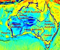
Figure 1. Gravity field of the Australian region. Cool colours (blues, greens)
are low, and hot colours (yellows, red) are highs. The superimposed lines
are boundaries of megaelements of the Australian continent (Meyers et. al., 1996).
CC Geoscience Australia
Some of the earliest studies (eg., Forman and Shaw, 1973) observed that, although the gravity highs and lows correspond loosely with Proterozoic basement rocks and Neoproterozoic to Palaeozoic sedimentary basins respectively, the transitions from highs to lows are displaced towards the basement regions, suggesting that either the basement regions overthrust the northern margins of the basins, or that the crust under regions of basement must have more low density rocks than the regions under the basins.
The region of anomalous gravity lies mostly within and adjacent to the Central Australian Megaelement, which is sandwiched between the North Australian and South Australian Megaelements (Figure 1 and Meyers et. al., 1996).
Each megaelement is a broad region of continent that amalgamated from smaller fragments during continental growth and then subsequently acted and reacted as a single structural entity.
A brief summary of the tectonic history of the region and references to earlier work are given by Korsch et. al. (1998).
The tectonic history of the region suggests that the structures responsible for the gravity anomalies are Palaeozoic in age, and that the gravity anomalies have endured for hundreds of millions of years. Early attempts to model the regional gravity field (see summary in Wright et. al., 1991) did not pay full attention to isostatic considerations.
Lambeck (1983) offered the hypothesis that the anomalies were caused by buckling and breaking of the crust under north-south compression. He suggested a tectonic model with a crustal structure broadly consistent with the observed gravity field.
Summary of results
Synopsis
Summaries of the results from the transect are given by: Korsch and others (1998) for the full length of the transect; Korsch & Kennard (1991) for the northern portion; and Leven & Lindsay (1995) for the southern portion.
Project description
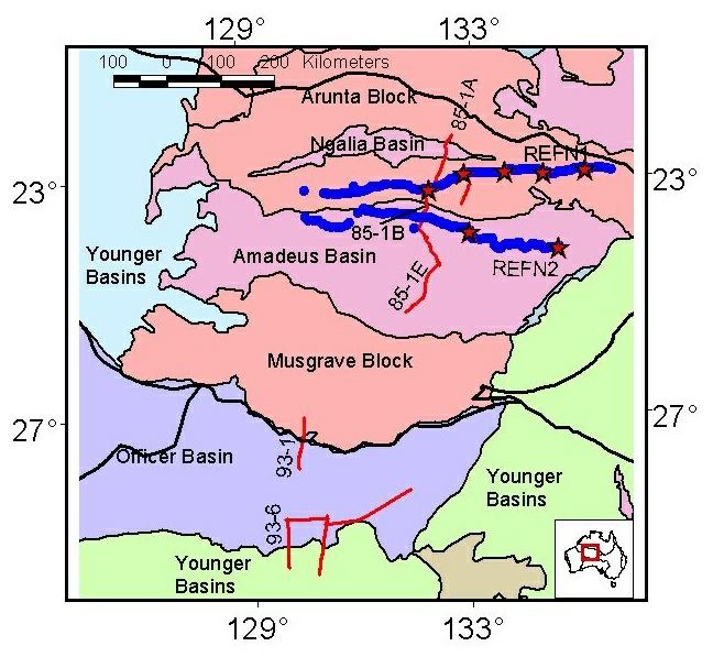
The transect was a multi-disciplinary study of the crust and upper mantle under the central and southern Arunta Block, the Musgrave Block, the intervening Amadeus Basin, and the northern Officer Basin to the south. The northern Arunta Block forms the southern part of the North Australian Megaelement in this region (Figure 2). The central and southern Arunta Block, the Amadeus Basin and the Musgrave Block lie within the Central Australian Megaelement. The Officer Basin lies in the northern part of the South Australian Megaelement.
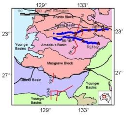
Figure 2. Simplified geology of the central Australian region.
Megaelement boundaries are shown as thick black lines.
Red lines show the position of deep vertical incidence reflection profiles.
Red stars show the positions of refraction shot points and blue dots
show the positions of refraction recording stations. The Central Australian
Megaelement
contains the Amadeus Basin, the central and southern
parts of the Arunta Block, and the Musgrave Block.
CC Geoscience Australia
Project results
The results of the transect studies show the crust to be 45-50 km thick throughout most of the region, and on the basis of limited seismic refraction profiling to be two layered in both basement regions and below the sedimentary cover.
Important exceptions to the uniform thickness occur. At the boundary of the Amadeus Basin and Arunta Block, seismic reflection data show the Arunta Block to have been thrust south over the northern margin of the basin. A tongue of mantle rock is thrust upwards along the Redbank and Ormiston Thrust Zones and the Moho is displaced
upwards locally by 25-30 km (Figure 3).
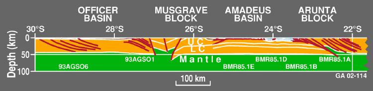
Figure 3. Simplified cross section from the Officer Basin in the south (left),
to the Arunta Block in the north (right).
No vertical exaggeration.
CC Geoscience Australia
Similar displacements are interpreted at the base of the crust between the southern Musgrave Block and the northern Officer basin, based on teleseismic residual studies and gravity modelling.
Internally, the crust in the Arunta Block, the Musgrave Block and beneath the Officer Basin is deformed along mostly north-dipping apparently planar shear zones that penetrate from the near surface to the base of the crust.
In contrast, the crust under the Amadeus Basin shows no evidence of north-dipping shear zones and contains a band of sub-horizontal reflections in the middle crust. The band of reflections is approximately 9 km thick and roughly parallels the bottom of the Amadeus Basin. The sedimentary fill in the Amadeus Basin shows thin-skinned deformation and duplication along bedding-parallel decollements.
The northern margins of the Amadeus and Officer Basins are severely deformed, with basin rocks thrust over the basement to the north. Locally in the Arunta Block basement to the north of the Amadeus Basin,
metamorphic grades reach granulite facies (8 kbars), indicating basement uplifts of up to 24 km. This is consistent with the amount of uplift on the Moho interpreted in the seismic reflection data. Erosion of the basement provided a source for a late foreland basin phase within the Amadeus Basin.
The results show a crust that has been shortened through regional contraction. The structures that are imaged seismically are probably those that showed the last movements, although geological evidence suggests that many would have been long lasting and periodically reactivated.
Research activities
Active source experiments
The research was undertaken in a number of phases.
Starting in 1985 and continuing for several years, the Bureau of Mineral Resources (now Geoscience Australia) undertook seismic reflection, refraction and geological studies over the central and southern Arunta Block and the northern and central Amadeus Basin. Red lines in Figure 2 show the position of deep vertical incidence reflection profiles (Goleby et. al., 1986). Red stars show the positions of refraction shot points and blue dots show the positions of refraction recording stations (Bracewell & Collins, 1986). A comprehensive summary of the results of this work is given in Korsch & Kennard (1991).
In 1993, the focus shifted south to the northern Officer Basin and Musgrave Block with the recording of deep seismic reflection data and associated geological studies (Leven & Lindsay, 1995).
Passive listening experiments
The Australian National University deployed portable seismographs acros the region in several experiments that aimed to use teleseismic travel time residuals from earthquakes around the Pacific Ocean to the southeast, east and north, and along the Indonesian Archipelago to the northwest (Lambeck et. al., 1988; McQueen & Lambeck, 1996). These experiments were especially important in providing information about Crustal structure in southern Amadeus Basin and the central and northern Musgrave Block because of access issues associated with seismic reflection profiling.
Tomographic images of the lithospheric and sub-lithospheric mantle througout the region were provided by the SKIPPY Project at the Australian National University, which deployed portable broad-band seismographs in a moving array across the entire Australian continent (van der Hilst and others, 1998; see also Layout and results of SKIPPY experiment).
Crust and mantle architecture
Mantle structure
Mantle structure was mostly derived by the SKIPPY Project at the Australian National University.
Crustal structure
Korsch et al., (1998) is the major source for the following summaries.
Geology of Central Australia
Terrane amalgamation to form a single, coherent crustal unit (the Central Australia mega-element) was probably completed by about 1100 Ma, in the late Mesoproterozoic, to form part of the Rodinian supercontinent.
The Ngalia, Amadeus and Officer Basins were initiated at about 800 Ma and sit on the Mesoproterozoic Musgrave and Arunta Blocks continental blocks. The basins contain Neoproterozoic to Late Devonian sedimentary fill. In their early history, these basins have a common history and form part of the Centralian Superbasin,
which initiated as a huge, gentle downwarp.
The web site Palaeogeography of Australia shows the palaeogeographic setting of central Australia throughout the Phanerozoic.
Since the Mesoproterozoic, central Australia has been the site of at least two major intraplate convergent events - the Petermann Ranges and the Alice Springs Orogenies - which resulted in the reactivation of Mesoproterozoic structures and the development of new contractional ones. The Petermann Ranges Orogeny was of
latest Neoproterozoic to Cambrian age (550-530 Ma). It was restricted to central and northwestern Australia and is thought to have originated from a change from a dominantly extensional regime to one of dextral shear. It mainly affected the Musgrave Block and southern Amadeus Basin.
The Alice Springs Orogeny is considered to be the intraplate response to far field stresses imparted at a plate boundary, probably to the north. The effects of the Alice Springs Orogeny are observed over much of central and eastern Australia. It appears to be long lasting (400-300 Ma) but reached its peak in the Arunta Block around 320 Ma. Significant thick-skinned contractional deformation of the crystalline crust occurred on deeply penetrating planar fault zones. In the basins, shortening was mostly thin skinned focussed mainly above salt horizons.
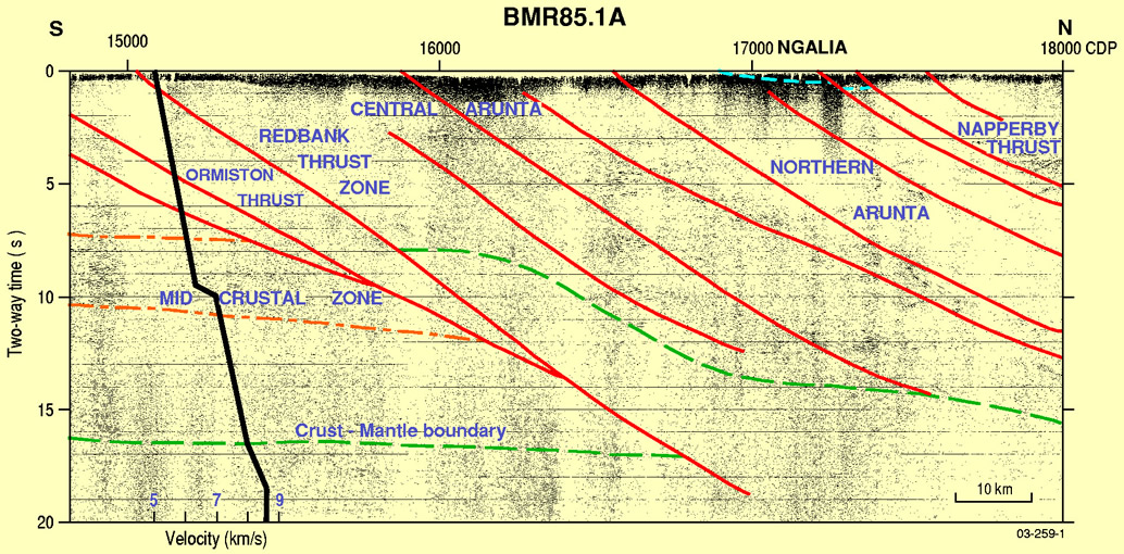
Geology of the southern Arunta Block (Line BMR85.1A)
The Arunta block has a moderately to strongly reflective middle to lower crust, but the upper crust is less reflective. The seismic section shows a series of planar, north-dipping reflections interpreted as parallel, planar thrust faults. Most are recognisable in the surface geology. Many extend into the lower crust.
Of these, the Redbank Thrust Zone displaces the Moho. Metamorphic grade changes abruptly across the Redbank Thrust Zone, from greenschist and amphibolite facies rocks exposed in the foot wall to the south to granulite facies rocks in the hanging wall exposed to the north. Mylonites within the Redbank Thrust Zone have been dated at 1500-1400 Ma, with reactivation and further mylonite development at about 400-350 Ma (Shaw & Black, 1991). The exposed granulites have been uplifted about 24 km, about half in the Mesoproterozoic and the other half during the Alice Springs Orogeny.
View a large version of the un-interpreted STACK image [JPG 2MB]
View a large version of the un-interpreted MIGRATED image [JPG 2MB]
The Moho under the southern Arunta block is about 50 km deep (confirmed by refraction profiling) and shallower, at 41-45 km deep in the central Aruntal Block. It shallows to about 24 km depth where the crust is thrust upwards at the Redbank Thrust Zone. These results are supported by Gravity modelling (Goleby
et al., 1989) and the interpretation of teleseismic travel times (Lambeck, 1991).
Central Australia has been tectonically stable since the Alice Springs Orogeny. The Moho topography has been preserved since that time. The region is out of local isostatic equilibrium but is compensated regionally.
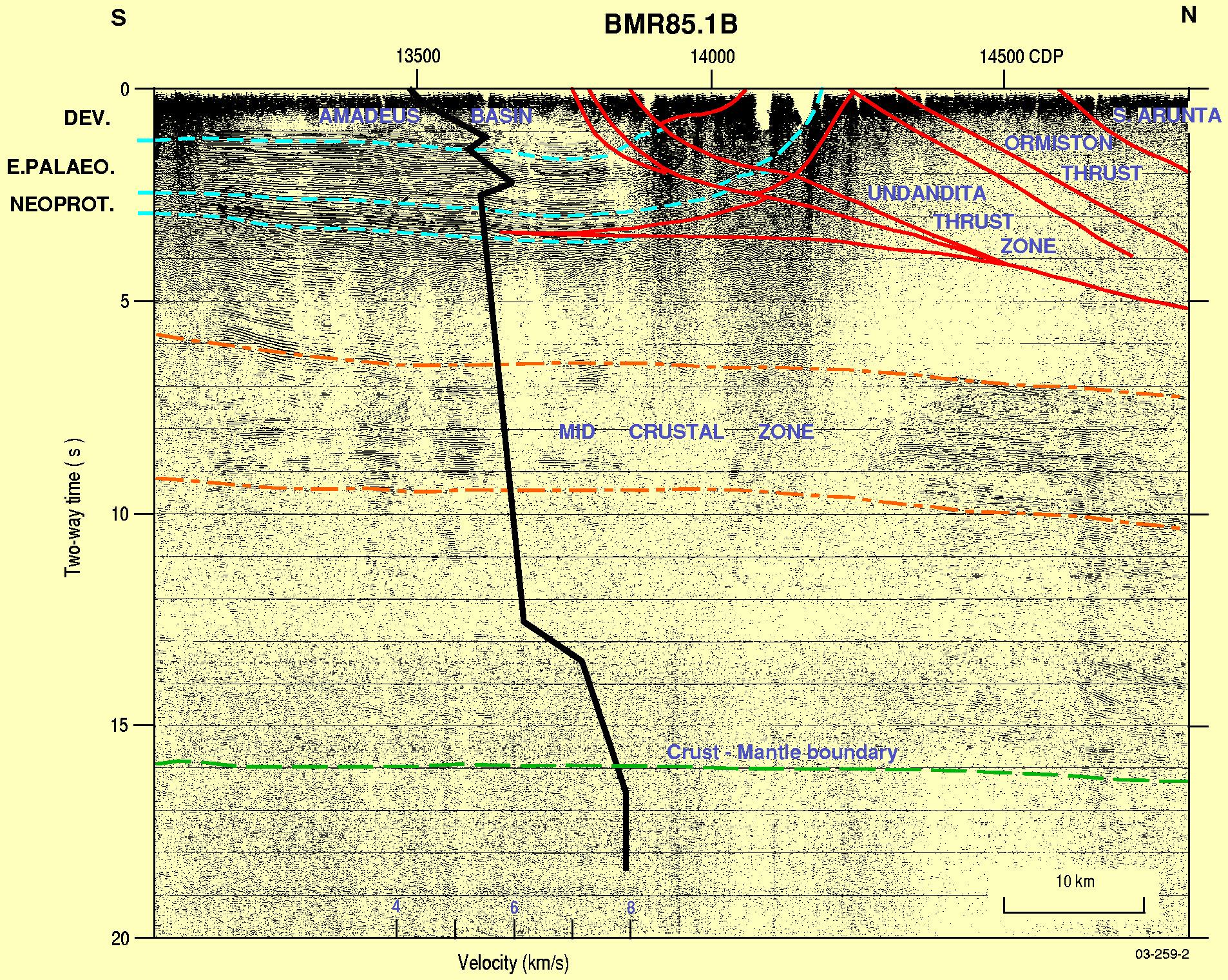
Northern Amadeus Basin and southern Arunta Block (Line BMR85.1B)
The crust under the northern Amadeus Basin is greater than 50 km thick, based on seismic reflection and refraction data.
It is divided into an upper crust with low reflectivity, a middle crust with strong, sub-horizontal reflections, and a lower crust with low to moderate reflectivity.
The planar north-dipping faults imaged in the crust of the Arunta Block extend as far south as the northernmost Amadeus Basin, and are absent farther south. They thrust Arunta Block rocks south over crust with middle crustal reflectivity similar to that found under the Amadeus Basin.
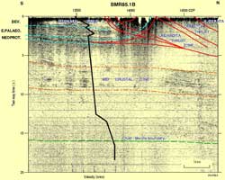
Figure 5. Illustrated is the interpreted seismic section
from the northern Amadeus Basin and Arunta Block.
CC Geoscience Australia
View a large version of the un-interpreted STACK image [JPG 2MB]
The northern Amadeus Basin is over 10 km thick in the vicinity of the seismic line. The basin sediments in the north are strongly folded to form the MacDonnell Homocline adjacent to the Arunta Block, with rotation and limited backthrusting in front of a south-directed imbricate basement thrust wedge. A triangle zone formed between the northern margin of the basin and the Ormiston Thrust. The Ormiston Thrust is a linear feature in the seismic section. It merges at about 40 km depth with the Redbank Thrust Zone. The Undandita Thrust Zone consists of low-angle thrusts that appear to cut all other structures, including the MacDonnell Homocline, and hence developed as one of the last events within the Alice Springs Orogeny.
Southern Amadeus Basin (Line BMR85.1E)
The Moho is ~50 km thick under the northern and southern margins of the Amadeus and shallows to ~47 km under the central basin. The middle crust has a band of sub-horizontal reflections that is shallower in the central basin and therefore roughly parallels the Moho. No north-dipping planar faults similar to those observed under the Arunta and northern Amadeus Basin were imaged under the central and southern basin. A single, south dipping reflection extending off the southern end of the seismic section is interpreted to be the Kernot Thrust Zone.
View a large version of the un-interpreted STACK image [JPG 2MB]
The central and southern Amadeus Basin is 3-6 km thick. Deformation in the basin sediments is by north-directed thin-skinned thrusting. The thrusts sole out in a salt horizon of the Neoproterozoic Bitter Springs Formation. In the southern Amadeus Basin, some of the folds and thrusts are considered to be of Petermann Orogeny age (550-530 Ma), but most deformation results from the Alice Springs Orogeny (400-300 Ma).
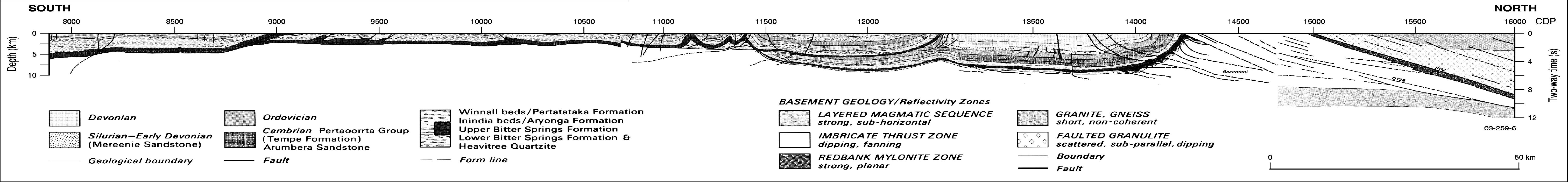
Southern Musgrave Block and northern Officer Basin (Line 93AGSO1)
Access limitations prevented a seismic profile across major mapped structures within the northern and central Musgrave Blocks. However, gravity modelling and teleseismic travel-time residuals indicate that the Moho has significant short wavelength topography in this region (see Figure 3).
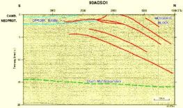
Figure 7. Interpreted seismic section from the southern Musgrave
block and northern Officer Basin (Line 93AGSO 01).
CC Geoscience Australia
View a large version of the un-interpreted STACK image [JPG 2MB]
The crust in the southern Musgrave Block and the northern Officer Basin thins to the south, from about 48 km in the north. It has low reflectivity except for several north-dipping reflections that can be traced through the whole crust. They are interpreted to be thrust faults. Several deform and rotate the sedimentary rocks in the northern Officer Basin into a homocline, similar to that observed in the northern Amadeus Basin. The deformation is interpreted to have occurred during the Alice Springs Orogeny (400-300 Ma). To the south, the sedimentary fill of the Officer Basin is relatively undeformed and reaches ~4.5 km thick.
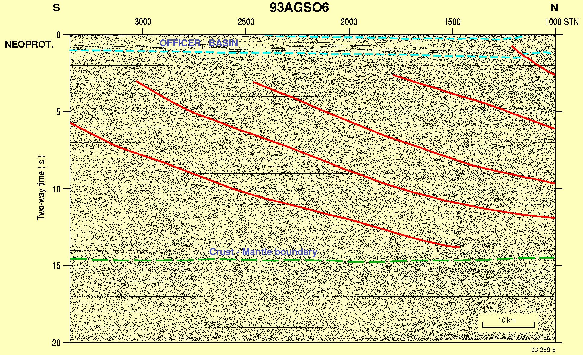
Southern Officer Basin (Line 93AGSO6)
The crust under the southern Officer Basin thins to the south, to about 44 km. It is mostly un-reflective, except for north dipping planar reflectors which extend to Moho depths, and are interpreted as Mesoproterozoic faults. One was reactivated, possibly during the Alice Springs Orogeny(400-300 Ma), folding the overlying Officer Basin sedimentary rocks.
View a large version of the un-interpreted STACK image [JPG 2MB]
Amadeus Basin structure
The structure of the Amadeus Basin was described by Shaw et al. (1991).
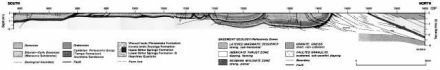
Figure 9. Cross section of the Amadeus Basin based on the deep seismic sections
and independent geological information.
CC Geoscience Australia
In the northern Amadeus Basin, a parautochtonous gently north-dipping sedimentary sequence between 8.5 and 12.0 km thick lies between the convergent thrust systems of the MacDonnel Homocline at the northern margin of the basin, and the Gardner Thrust farther south. The MacDonnell Homocline was formed by southward thrusting of a basement wedge under the northern margin of the basin. The vertical uplift in the southern hanging wall of Gardiner Thrust is about 6 km. The sedimentary succession is repeated south of the Gardiner Thrust through north-directed thrusting along a decollement zone localised in a salt horizon of the Bitter Springs Formation. In the south of the basin, an imbricate thrust system fans ahead of the Kernot Thrust. Most shortening of the basin fill occurred during the Alice Springs Orogeny, with reactivation of earlier thrust systems in the north (Ormiston Thrust, Redbank Thrust Zone) and south (Kernot Thrust) that formed during earlier orogenies.
Gravity model (Line BMR85.1A)
The interpretation of a major slice of mantle material thrust upwards along the Redbank Thrust Zone is consistent with the gravity field in the region. The Gravity model shown here was constructed using crustal geometries interpreted from the seismic reflection data and reasonable estimates of rock density. It shows close agreement between the observed gravity field and that calculated for the model.
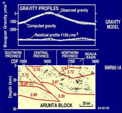
Figure 10. Gravity model of the Arunta Block
along BMR Line 85.1A (From Goleby et al., 1989)
CC Geoscience Australia
Crustal deformation styles
The ideas set out in this section have been presented and discussed in national geological meetings but have not been peer reviewed.
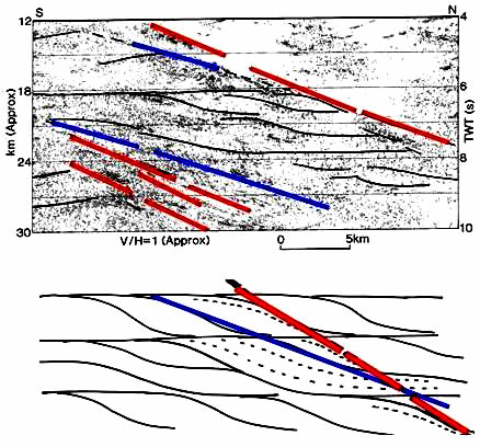
Figure 11. The reflections in the crystalline crust (upper part)
and summary cartoon of reflection geometries.
CC Geoscience Australia
The impression gained from the summary images of the Arunta block and the Officer Basin is of a crust that shortened in a domino and perhaps brittle style along planar north-dipping faults. The detailed reflectivity patterns within the Arunta block suggest that the deformation may have been more ductile.
The observed reflections can be categorised as (i) pervasive curved reflections that fall into patterns similar to duplexes, with linear horizontal segments joined by north-dipping curved segments (thin black lines in the diagram) and (ii) long, linear, north-dipping reflections. The long, linear reflections mostly have one of two dips - the red ones are steeper than the blue ones. The blue reflections have dips that are similar to the dipping segments of the curvilinear reflections.
The reflection patterns would be consistent with, but do not prove or require that, ductile shortening of the crust, with through-going (blue) faults forming along the edges of the duplexes. A focus on the long, linear reflections gives the impression of a crust deformed only through steep planar faults in a domino style. However, as the crust continued to shorten, the internal deformation of the crust would have continued to be through ductile deformation, so that the duplex structure would remain a constant feature, but any early-formed, through-going faults would have rotated and become steeper (now seen as red reflections). Thus the red reflections would be older than the blue reflections.
Examples would be the Ormiston Thrust, which splays at a shallower angle off the Redbank Thrust Zone in the southern Arunta block.
Recording and processing parameters
Lines BMR85 1A, 1B, 1E
| Recording parameters |
| Dates recorded |
July-August 1985 |
| Recording system |
DFS IV |
| Tape format |
SEG B
1600bpi phase encoded |
| Number of channels |
48 |
| Record length |
20s |
| Sample rate |
2ms |
| Recording filters |
Low cut 8Hz, 36db/octave
High cut 124Hz, 72db/octave
Notch out |
| Source |
Dynamite (ICI anzite blue)
12kg (nominal charge size)
40m depth to bottom of charge |
| Shotpoint interval |
333.3m |
| Channel numbers |
48-25-1 |
| Spread pattern |
1917-0-2000m |
| Shot on trace |
25 (no centre gap) |
| Group pattern |
16 in-line, 5m spacing |
| Group interval |
83.33M |
| Coverage |
600% |
| Processing sequence |
| Demultiplex |
SEG B to SEG Y |
| Geometry definition |
|
| Resample |
to 4ms |
| Trace edits |
|
| CDP sort |
Crooked line |
| Spherical divergence correction |
C=1.0, V=2.0, T=1.0
At a velocity function=5,000-6,000m/s |
| Refraction statics |
Datum 550m
Replacement velocity 5000m/s
Weathering velocity 1400m/s |
| Normal moveout correction (NMO) |
|
| NMO stretch mute |
20% |
| Bandpass filter |
Time(s) bandpass (Hz)/slope (db/octave)
0.0 20/36-80/36
4.0 15/36-60/36
12.0 15/36-40/36
20.0 10/36-30/36 |
| Trace balance |
Single equalisation gate 3-12s |
| Median stack |
|
| Digistack |
Form of weighted running trace mix |
| FK migration on selected sections |
Constant velocity 6000m/s |
| Resample |
To 8ms |
| Display |
Variable area, clip=2, bias=-0.75 |
| Polarity |
+ve on tape
= Upward ground displacement
= Peak (black) on section
i.e., SEG convention |
Lines 93AGSO 01 and 02
| Recording parameters |
| Dates recorded |
September-October, 1993 |
| Recording system |
Sercel Sn368 |
| Tape format |
SEG D multiplexed
6250bpi GCR |
| Number of channels |
120 |
| Record length |
20s |
| Sample rate |
2ms |
| Recording filters |
Low cut 8Hz, 18db/octave
High cut 178Hz, 72db/octave
Notch out |
| Source |
Dynamite (ICI anzite blue)
10kg (nominal)
40m to bottom of charge |
| Shotpoint interval |
240m |
| Spread pattern |
2380-20-20-2380 |
| Maximum offset |
4760m |
| Group pattern |
16 in-line, 2.5m spacing |
| Group interval |
40m |
| Coverage |
1000% |
| Processing sequence |
| Demultiplex |
SEG D to SEG Y |
| Geometry definition |
Crooked line |
| Resample |
to 4ms |
| Trace edits |
|
| Notch filter |
75Hz on traces near recording cab |
| Refraction statics |
Datum 100m
Replacement velocity 3500m/s on Line 93AGSO 06
Replacement velocity 3800m/s on Line 93AGSO 01 |
| Residual statics |
|
| Normal moveout correction (NMO) |
|
| Stretch mute |
Post NMO |
| FK filter |
|
| Sort |
To common mid point |
| Trace scale |
|
| Stack |
|
| Bandpass filter |
|
| Trace scale |
|
| Display |
Variable area |
| Polarity |
+ve on tape
= Upward ground displacement
= Peak (black) on section
i.e., SEG convention |
Data availability
Seismic reflection and refraction data
The Seismic reflection and refraction data referenced in this transect web site are available at the cost of transfer (Aus$99 per CD) from:
- Sales Centre - Attention: Land Seismic Data Custodian, Geoscience Australia
- Postal Address:
- GPO Box 378
Canberra ACT 2601
Australia
Telephone +61 2 6249 9111
Facsimile +61 2 6249 9960
- Courier Address:
- Corner Jerrabomberra Avenue and Hindmarsh Drive
Symonston ACT 2609
Australia
Geological and potential field data
Geological and potential field data are available for viewing at Australian National Geoscience Datasets Online.
This site will also direct you to download sites where you can access the digital geological and geophysical data for free. You can go straight to the download site for the potential field geophysics at Free downloads of geophysical data.
Bibliography
The following list of references is not exhaustive. Wherever possible, representative and often the most recent publications have been chosen for each topic. Readers will be able to follow the publication history and find earlier references through the reference lists in each publication.
Bracewell, R. & Collins, C.D.N., 1986. Central Australia Refraction Survey, 1985. Bureau of Mineral Resources, Australia, Record 1986/13.
Forman, D.J. & Shaw, R.D., 1973.ĀDeformation of the crust and mantle in central Australia.ĀBureau of Mineral Resources, Australia, Bulletin, 144, 20pp.
Goleby, B.R., Shaw, R.D., Wright, C., Kennett, B.L.N., and Lambeck, K., 1989.ĀGeophysical evidence for æthick-skinnedÆ crustal deformation in central Australia. Nature, 337, 325-330.
Goleby, B.R., Wake-Dyster, K.D., Wright, C. & Cherry, E.H., 1986. Central Australia Seismic Survey, NT, Operational Report. Bureau of Mineral Resources, Australia, Record, 86/35.
Goleby, B.R., Wright, C., Collins, C.D.N. & Kennett, B.L.N., 1988.ĀSeismic reflection and refraction profiling across the Arunta block and the Ngalia and Amadeus Basins.ĀAustralian Journal of Earth Sciences, 35, 275-294.
Korsch, R.J., Goleby, B.R., Leven, J.H. & Drummond, B.J., 1988.ĀCrustal architecture of central Australia based on deep seismic reflection profiling.ĀTectonophysics 288, 57-69.
Korsch, R.J. & Kennard, J.M. (editors), 1991.ĀGeological & geophysical studies in the Amadeus Basin central Australia.ĀBureau of Mineral Resources, Australia, Bulletin, 236, 5948.
Lambeck, K., 1983.ĀStructure and evolution of the intracratonic basins of central Australia.ĀGeophysical Journal of the Royal Astronomical Society, 74, 843-866.
Lambeck, K., 1991.ĀTeleseismic travel-time anomalies and deep Crustal structure of the northern and southern margins of the Amadeus Basin.ĀIn R.J. Korsch and J.M. Kennard (editors). Geological & geophysical studies in the Amadeus Basin central Australia.Ā Bureau of Mineral Resources, Australia, Bulletin, 236, 409-427.
Lambeck, K., Burgess, G. & Shaw, R.D., 1988.ĀTeleseismic travel-time anomalies and deep Crustal structure in central Australia.ĀGeophysical Journal, 94, 105-124.
Leven, J.H. & Lindsay, J.F., 1995.Ā A geophysical investigation of the southern margin of the Musgrave Block, South Australia.ĀAGSO Journal of Australian Geology & Geophysics, 16, 155-161.
Lindsay, J., Leven, J. & Krieg, G., 1992 Central Officer Basin South Australia, Seismic data acquisition, 1993. Australian Geological Survey Organisation, Record, 1992/89.
McQueen, H.W.S. & Lambeck, K., 1996.ĀDetermination of Crustal structure in central Australia by inversion of traveltime residuals.ĀGeophysical Journal International, 126, 645-662.
Meyers, J.S., Shaw, R.D. & Tyler, I.M., 1996.ĀTectonic evolution of Proterozoic Australia.ĀTectonics, 15, 1431-1446.
Shaw, R.D. & Black, L.P., 1991. History and tectonic implications of the Redbank Thrust Zone, central Australia, based on structural, metamorphic and Pb-Sr isotopic evidence. Australian Journal of Earth Sciences, 38, 307-332.
Wright, C., Barton, T., Goleby, B.R., 1988.ĀLateral variations in seismic velocities in the central Australian region from both conventional and experimental reflection profiling.ĀExploration Geophysics, 19, 214-221.
Wright, C., Goleby, B.R., Collins, C.D.N., Korsch, R.J., Barton, T., Greenhalgh, S.A. & Sugiharto, S., 1990.ĀDeep seismic profiling in central Australia. Tectonophysics, 173, 247-256.
Shaw, R.D., Korsch, R.J., Goleby, B.R., Wright, C., & 1991.ĀSeismic interpretation and thrust tectonics of the Amadeus Basin, central Australia, along the BMR regional seismic line.ĀIn R.J. Korsch and J.M. Kennard (editors).ĀGeological & geophysical studies in the Amadeus Basin central Australia.ĀBureau of Mineral Resources, Australia, Bulletin, 236, 385-408.
Wright, C., Goleby, B.R., Shaw, R.D., Collins, C.D.N., Korsch, R.J., Barton, T., Greenhalgh, S.A. & Sugiharto, S., 1991.ĀSeismic reflection and refraction profiling in central Australia: implications for understanding the evolution of the Amadius Basin.ĀIn R.J. Korsch and J.M. Kennard (editors).ĀGeological & geophysical studies in the Amadeus Basin central Australia.ĀBureau of Mineral Resources, Australia, Bulletin, 236, 41-57.
Van der Hilst, R.D., Kennett, B.L.N. & Shibutani, T., 1998. Upper Mantle structure beneath Australia from portable array deployments. American Geophysical Union, Geodynamics Series, 26, 39-57.
Map library
The map images available through the following links provide an overview of the geography and regional geology and geophysics of the central Australian region. The data themes can be used, along with other data layers, to make more maps images.
Please note file sizes before downloading images.
Seismic image library
Please note file sizes before downloading images.
Photographs

A drilling rig with explosives in the bottom of drill holes which were used as the seismic source.
CC Geoscience Australia
[an error occurred while processing this directive]


![un-interpreted STACK image [JPG 2MB]](/build/img/central-aust-fig4-display-stack.jpg)
![un-interpreted MIGRATED image [JPG 2MB]](/build/img/central-aust-fig4-display-migrated.jpg)
![un-interpreted STACK image [JPG 2MB]](/build/img/central-aust-fig5-display-stack.jpg)
![un-interpreted STACK image [JPG 2MB]](/build/img/central-aust-fig6-display-stack.jpg)
![un-interpreted STACK image [JPG 2MB]](/build/img/central-aust-fig7-display-stack.jpg)
![un-interpreted STACK image [JPG 2MB]](/build/img/central-aust-fig8-display-stack.jpg)
![DEM and topographical features [JPG 463kb]](/build/img/central-aust-dem-topo-features-display.jpg)
![Geology [JPG 123kb]](/build/img/central-aust-geology-display.jpg)
![Gravity [JPG 145kb]](/build/img/central-aust-gravity-display.jpg)
![Colour magnetics [JPG 280kb]](/build/img/central-aust-colour-magnetics-display.jpg)
![Grey-scale magnetics [JPG 180kb]](/build/img/central-aust-grey-scale-magnetics-display.jpg)
![Landsat [JPG 210kb]](/build/img/central-aust-landsat-display.jpg)