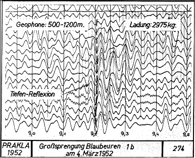
Seismic reflections recorded in 1952 from the Moho
at about 9.2 seconds two-way time (TWT) using
large charges detonated at a cement quarry, 1952 (Reich, 1957).
Updated: Dec 09, 2024
Seismic profiling on a crustal scale has had a long tradition in Germany. Recordings of explosions at distances of 10's and 100's of kilometres was the early wide-angle seismic method used to determine the velocity structure of the crust and upper mantle but in the 1950's recordings were also made at near-vertical incidence using quarry explosions in a number of places. Also, as in many other parts of the world, seismic reflection profiling was being conducted in the search for oil and gas resources.
In Germany during the 1950's a number of seismic recordings were made at near-vertical incidence during deep sounding experiments at specific sites. Some of the recorded seismic phases were identified as being reflections from intra-crustal horizons and also from the Moho (e.g. Reich, 1957; Dohr, 1957)

Seismic reflections recorded in 1952 from the Moho
at about 9.2 seconds two-way time (TWT) using
large charges detonated at a cement quarry, 1952 (Reich, 1957).
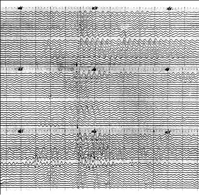
Deep seismic reflections at about 11 seconds two-way time (TWT)
(30-31 km depth) recorded on three records (Dohr, 1957).
Also during the late 1950's oil exploration companies working in the Tertiary Munich Basin and other Alpine foreland basins of southern Bavaria were routinely making recordings with record lengths of 12 seconds from their seismic shots (Liebscher, 1962). These recordings enabled reflection events from within the basement to the sedimentary basins to be identified. Liebscher (1962) examined about 1800 such recordings and was able to prepare rudimentary profiles of the Earth's crust across the region.
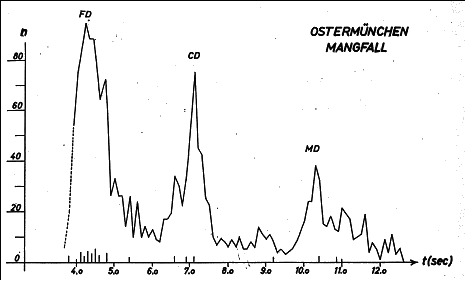
Histogram of reflection events from seismic profiling
about 40 km southeast of Munich (Liebscher, 1962).
FD = Förtsch Discontinuity; CD = Conrad Discontinuity;
MD = Mohorovicic Discontinuity.
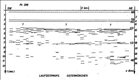
Profile of reflection events along a 15 km profile southwest of Munich (Liebscher, 1962).
FD = Förtsch Discontinuity; CD = Conrad Discontinuity; MD = Mohorovicic Discontinuity.
Thus, in the 1950's - 1960's, seismologists in Germany were well aware that near-vertical incidence reflections could be recorded from deep within the Earth's crust. Workers in other countries such as Australia, Canada, USA, and elsewhere were conducting similar experimental seismic soundings.
For many years however the emphasis in seismic studies of the continental crust in Europe concentrated on the wide-angle seismic method for determining depths to various velocity horizons including the Moho. Much of the work in Germany is summarised by Giese et al., (1976).

Quarries used a seismic shot sources for wide-angle seismic profiling
of the Earth's crust across Germany, 1950's to 1970's (from Giese et al., 1976).

Depth to the Moho (in kilometres) across Germany derived
from wide-angle seismic profiling (Giese et al., 1976).
A glance at the tectonic map of Europe gives some idea of the complexities inherent in the Earth's crust across the region and, in order to determine the deep geology in some detail, a deep seismic reflection profiling programme was necessary.
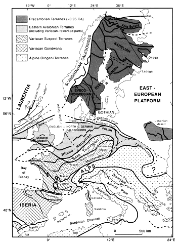
Tectonic elements across central Europe (Blundell, Freeman & Mueller, 1992).
A brief history of DEKORP is available on the GeoForschungsZentrum (GFZ), Potsdam, website http://www-app1.gfz-potsdam.de/www/pb3/dekorp/welcome.html from which the following is taken:
"DEKORP was founded in 1983 with the aim to investigate the deep crustal structure of Germany with high-resolution near-vertical incidence seismic methods. It was closely associated with the deep drilling project KTB (German continental deep-drilling program) as well as other European deep-seismic programs (e.g. BELCORP in Belgium and ECORS in France).
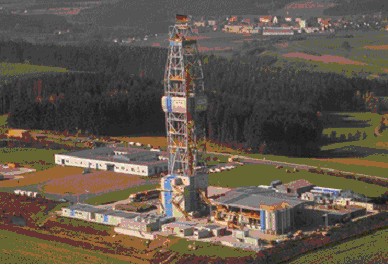
KTB well site at Windischeschenbachin south-eastern Bavaria near Bayreuth.
The two super-deep boreholes (4000m and 9101m) of the German Continental Deep Drilling Program
yielded essential insights in the structure and processes of the upper crust of the Earth.
(Photo and text from http://www.icdp-online.de/welcome.html).
The near-vertical incidence seismic experiments of DEKORP were supplemented by wide-angle seismic experiments, and were also accompanied by research projects which were designed to improve and optimize methods of processing and interpretation. Another purpose was an intensified cooperation with industry.
DEKORP (Deutsches Kontinentales Reflexionsseismisches Programm) was carried out between 1984 - 1997 as the German national reflection seismic program funded by the Federal Ministry of Education, Science and Technology (BMFT), now Federal Ministry of Education and Science (BMBF). From 1983 to 1994 DEKORP was administrated by the Geological Survey of Lower Saxony, Hannover. In 1994 the DEKORP management was taken over by Section 3.1 of the GeoForschungsZentrum Potsdam.

Geological Survey of Lower Saxony, Hanover
The main research topic of DEKORP deep seismic studies during the first 10 years was to investigate the lithospheric structure beneath Germany. The resulting seismic images were essential contributions to:
- Geological research projects revealing different units of the Central European Variscides in Germany,
- Exploration studies for a suitable KTB drilling site.
- Supplementary and comparative experiments to the KTB."
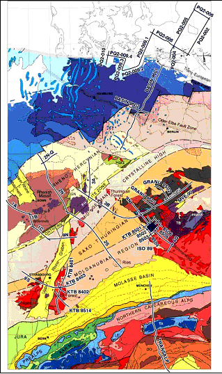
Location of DEKORP deep seismic profiles across central Europe
(from DEKORP website http://www-app1.gfz-potsdam.de/www/pb3/dekorp/welcome.html)
| Year | Survey | Location |
|---|---|---|
| 1984 | DEKORP 2S | Spessart mountains, Hessian Trough |
| KTB 84(1-3) | Black Forest | |
| 1985 | DEKORP 4 and 4Q | Oberpfalz |
| KTB 85(1-6/14) | Oberpfalz/Black Forest | |
| 1986 | DEKORP 2N and 2Q | Rhenish Massif |
| 1987 | DEKORP 1A and 1B | Ardennes/Rhenish Massif |
| 1988 | DEKORP 1C, 9N and 9S | Hunsrück/Upper Rhinegraben |
| 1989 | ISO 89 3-D | Oberpfalz |
| 1990 | DEKORP 3/ MVE-90 | Hessian Depression/Bohemian Massif |
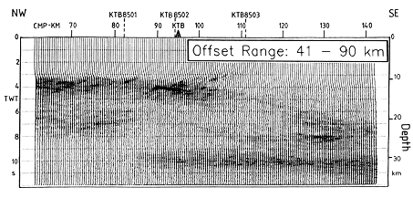
A stacked wide-angle seismic profile across the KTB site
showing the prominence of the high-velocity ( > 7 km/s) Erbendorf body
at 3.5 - 5.0 seconds two-way time (TWT) (10-14 km depth)
(from Gebrande et al., 1990).
Seismic sections from the various DEKORP deep seismic profiles are contained in the DEKORP Atlas (Meissner & Bortfeld, 1990). Some results from the first DEKORP seismic line illustrate the images available from across this region of central Europe.
The first deep seismic profile acquired by DEKORP was Line 2S. The DEKORP web site http://www-app1.gfz-potsdam.de/www/pb3/dekorp/dekorp2.html gives details of the line and acquisition and interpretation. Only a summary is presented below. The deep seismic profile crosses the Mid-German crystalline High (Spessart Mountains), and the Saxothurgian and Moldanubian sub-provinces of the Variscan Fold Belt.

DEKORP deep seismic profile Line 2S (from DEKORP web site)
Extracts from DEKORP web site:
The first DEKORP line, DEKORP 2S, was the only one which mainly used chemical explosions as the seismic source. The 248 km long, NW-SE striking profile extends from the Rhenohercynian Taunus Mountains to the Danube River thereby crossing the Spessart Mountains, the Hessian Trough and the "Nördlinger Ries".
The most important results of DEKORP 2S are predominantly SE-dipping reflectors indicating flat-and-ramp tectonics and a differentiation into a highly reflective lower crust and a less reflective upper crust. This structural fabric extends to the NW as shown by the line DEKORP 2N.
In addition:
- SE-dipping thrusts in the upper crust mark the boundary between Saxothuringian and Rhenohercynian below the Spessart Mountains,
- A concentration of diffraction effects occurs in the lower crust (5 - 10s TWT), predominantly vertically arranged and possibly related to
- Post-Variscan extensional or wrench faulting or ramps and horsts of the Saxothuringian - Moldanubian thrust system.
Detailed results are published in the following journal papers:
DEKORP Research Group: First Results and preliminary interpretation of deep-reflection seismic recordings along profile DEKORP 2-South. J. Geophys., 57, pp. 137-163, 1985.
Behr, H.J. & Heinrichs, T.: Geological interpretation of DEKORP 2-S: a deep seismic reflection profile across the Saxothuringian and possible implications for the Late Variscan structural evolution of Central Europe. Tectonophysics, 142(2-4), pp. 173-202, 1987.
Oncken, O.: Transformation of a magmatic arc and an orogenic root during oblique collision and its consequences for the evolution of the European Variscides (Mid-German Crystalline Rise). Geol. Rdsch., 86, pp. 2-20, 1997.
Oncken, O. : Orogenic mass transfer and reflection seismic patterns - evidence from DEKORP sections across the European Variscides (central Germany). Tectonophysics, 286, pp. 47-61, 1998.
Oncken, O. :Evidence for precollisional subduction erosion in ancient collisional belts: The case of the Mid-European Variscides. Geology, 26(12), pp. 1075-1078, 1998.
| General information | ||
|---|---|---|
| Recorded | April-May '84 | |
| by | Prakla-Seismos AG | |
| for | Geological Survey of Lower Saxony | |
| Area | Odenwald, Hessen / BW | |
| Profile length | 248km | |
| Total data amount | 2.92GB | |
| Recording | ||
| Recording System | Sercel SN 348 / MTA -09 | |
| Sample rate | 4ms | |
| Number of channels | 200 | |
| Field filter | Lo 8Hz / 18dB Hi 62.5Hz / 72dB | |
| Correlation | with filtered sweep | |
| Recording Time | 20s + 20s = 40s | |
| Receivers | ||
| Geophone type | SM 4 / 10Hz | |
| Geophones/Group | 24 fold | |
| Receiver array | In-line | |
| Group spacing | 80m | |
| No.of geophone points | 200 | |
| Spread length | 15.92km | |
| Sources | ||
| Source type | Vibroseis bzw. | |
| Vitesit (max. 30kg/ hole) | ||
| Holes/ Shotpoint: 1-3 | Depth: max. 30m | |
| Number of vibrators | 5*VVEA | |
| Sweep length | 20s | |
| Sweep range | 12 - 48Hz | |
| Recording Configuration | symmetrical split-spread (7960-40-VP-40-7960m) |
|
| Source spacing | 320m | |
| Number of source points | 784 | |
| Pattern length | 120m | |
| Vertical stacking rate | ||
| CMP's | ||
| Coverage (theor./real) | 25 fold (near verticale angle); | |
| 6 fold (wide angle) | ||
| CMP-spacing | 40m | |
| Number of CMP's | 6253 | |
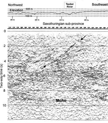
Part of DEKORP Line 2S near the Tauber River
showing prominent
dipping
reflectors in the upper crust near boundary
between the Saxothuringian
sub-province and the Moldanubian sub-province
to the southeast.
The geological boundary also shows on the increased elevation by about 150 m
towards the southeast (adapted from DEKORP Atlas, Meissner & Bortfeld, 1990).
Meissner andWever (1990) describe the DEKORP Line 2S in the following terms in the DEKORP Atlas:
The combined lines DEKORP 2N and DEKORP 2S cross all Variscan units perpendicular to the strike direction, starting in the Variscan Foreland in the NNW, crossing the Rhenohercynian and Saxothuringian sub-provinces and ending in the Moldanubian in the south (at the Danube River).
The DEKORP 2S deep seismic profile (248km) was the first of DEKORP's lines, and the only one shot with explosive sources. It starts in the northeast near Frankfurt, passes about 55km west of Nuremberg (near the Tauber River) and ends at the Danube River in the southeast near Donauworth. The line shows the boundary between the Saxothuringian and the Rhenohercynian in its northern part below the Spessart Mountains. Several SE-clipping thrusts in the upper crust mark this boundary which (unlike the Saar Nahe basin on line 1C) was not involved in any substantial post-Variscan extension.
Below the Spessart Mountains an unusually strong cluster of diffractions is observed in the middle and lower crust (DEKORP Res. Group 1985; Behr and Heinrichs 1987). The lower crust gradually assumes the laminated appearance of Variscan extensional regimes, although in the upper crust some compressional features have survived, as seen by occasional strongly dipping reflections like those around the boundary between Moldanubian and Saxothuringian. Below the town of Dinkelsbuhl another strong cluster of diffractions is present in the lower crust, possibly connected to small-scale intrusions or to diffuse thrust planes of Moldanubian over Saxothuringian (Sadowiak et al. 1989).
In general, compressional tectonics seem to be less developed along 2S than along 2N (in the Rhenish Massif) although the major zones of collision are still preserved in the upper crust. In the lower crust no signs of former crustal roots can be detected. Any lower crust lamellae must be younger than the Variscan crustal shortening.
The European Geotraverse (EGT) (Blundell, Freeman & Mueller, 1992) crosses the DEKORP Line 2S and provides some idea of the crustal P-wave velocities and interpreted structures in the vicinity of the deep seismic profile.
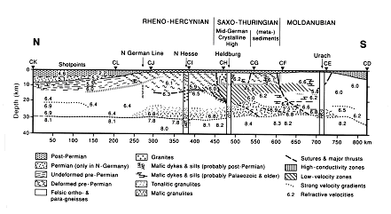
Composite cross section of the Earth's crust across the central part of the EGT
near DEKORP Line 2S showing crustal velocities (in km/s), interpreted structures
and geological interpretations (from Blundell et al, 1992; Franke et al., 1990; Prodehl & Aichroth, 1992).
CG-CF is the approximate location of DEKORP Line 2S near the Tauber River.
Blundell, D., Freeman, R., and Mueller, S., 1992. A continent revealed: the European Geotraverse. Cambridge University Press.
Dohr, G., 1957. Ein Beitrag der Reflexionsseismik zur Erforschung des tieferen Untergrundes. Geologische Runschau, 46, 17-26.
Franke, W., Giese, P., Grosse, S., Haak, V., Kern, H., Mengel, K., and Onken, O., 1990. Geophysical imagery of geological structures along the central segment of the EGT. In: R. Freeman, P. Giese and St. Mueller (eds), The European Geotraverse: Integrative Studies, European Science Foundation, Strasbourg, 177-186.
Gebrande, H., Bopp, M., Meichelbock, M., and Neurieder, P., 1990. 3-D wide-angle investigations in the KTB surroundings as part of the "Integrated Seismics Oberpfalz 1989 (ISO89)". In: KTB Report 90-6b, DEKORP Report (eds. H-J. Durbaum, Ch. Reichert and K. Bram), Niedersachsisches Landesamt fur Bodenforschung, Hanover, 183-208.
Giese, P., Prodehl, C., and Stein, A., (eds.), 1976. Explosion Seismology in Central Europe. Springer, Berlin.
Liebscher, H., 1962. Reflexionshorizonte der tieferen Erdkruste im bayerischen Alpenvorland, abgeleitet aus Ergebnissen der Reflexionsseismik. Zeitschrift der Geophysik, 28, 162-184.
Meissner, R., Wever, Th. and Bittner, R., 1987. Results of DEKORP 2-S and other reflection profiles through the Variscides. Geophysical Journal of the Royal Astronomical Society, 89. 319-324.
Meissner, R. and Wever, Th., 1990. Presentation of data. In: DEKORP Atlas: Results of Deutsches Kontinentales Reflexionsseismisches Programm (eds Meissner, R., and Bortfeld, R. K.) Springer-Verlag, Berlin.
Meissner, R., and Bortfeld, R. K., 1990. DEKORP Atlas: Results of Deutsches Kontinentales Reflexionsseismisches Programm. Springer-Verlag, Berlin.
Prodehl, C., and Aichroth, B., 1992. Seismic investigations along the European Geotraverse and its surroundings in Central Europe. Terra Nova 4, 14-24.
Reich, H., 1957. In Suddeutschland seismisch Ermittelte tiefe Grenzflachen und ihre geologische Bedeutung. Geologische Runschau, 46, 1-17.
[an error occurred while processing this directive]