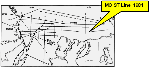
Location of the MOIST deep seismic profile north of Scotland (from Flack & Warner, 1990)
Updated: Dec 09, 2024
The 1970's and 1980's saw the onset of a hugh seismic reflection profiling programme by the exploration industry to exploit the oil and gas resources of the North Sea and other areas of the continental shelf around the British Isles. It soon became clear that there was a lack of knowledge about the tectonic processes that had shaped the geological structures of the continental shelf and its sedimentary basins. A detailed tectonic history of a sedimentary basin – source rock history, temperature/pressure/depth of burial history, structure/reservoir trap history – are all essential elements in identifying oil and gas resources. There was a need to examine in more detail the structures deep within the Earth's crust across the continental shelf around the British Isles and form a better understanding of crustal evolution and sedimentary basin formation.
The early history of BIRPS is outlined in "The BIRPS Atlas" by Klemperer & Hobbs (1991). In the 1970's there had been various groups around the world using seismic reflection profiling methods to investigate the deep geology of the continental crust. In 1976 the Royal Society in London formed a working group of university and Natural Environment Research Council (NERC) seismologists under the chairmanship of Dr. Hal Thirlaway to investigate the feasibility of conducting seismic reflection profiling investigations of deep geology in and around Britain.
After some background work, the Royal Society Working Group asked Professors Derek Blundell (Royal Holloway College, University of London) and Drum Matthews (Cambridge University) to develop a programme for a national program on behalf of the British Universities Reflection Profiling Syndicate (BURPS). (Blundell, D. J. 1979 – A study into the feasibility of using seismic reflection profiling to probe the deep structure of the crust of Britain. Unpublished report to NERC, pp23)

Location of the MOIST deep seismic profile north of Scotland (from Flack & Warner, 1990)
In February 1981, NERC approved funding for a four year research program that led to a pilot survey, the MOIST marine seismic research project, being undertaken north of Scotland in March 1981 (see below).
This initial UK deep seismic profile provided some outstanding results:
 Other institutions were incorporated into the UK national seismic research program and BURPS became BIRPS, the British Institutions Reflection Profiling Syndicate, with Prof. Drum Matthews as Director and with an advisory committee under the chairmanship of Prof. Derek Blundell (Klemperer & Hobbs, 1991)
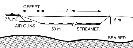
Sketch of a marine seismic profiling configuration used by BIRPS (from Warner, 1986).
The results from the MOIST project highlighted the cost effectiveness of conducting investigations of the continental shelf deep geology using an oil exploration industry seismic shooting ship as a platform for the seismic source and data acquisition techniques coupled with modified industry seismic data processing techniques. The seas around the British Isles provided an ideal environment for such work; geological structures identified onshore could be extrapolated offshore and thus provide a very good avenue for interpretation of deep seismic reflections.
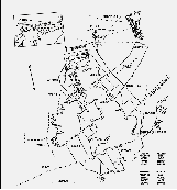
BIRPS deep seismic profiles shot across the continental shelf
around UK during the 1980's (from Klemperer & Hobbs, 1991).
[View larger image]
BIRPS was formally launched at meeting held at the Royal Society of London on 9 November, 1981. The emphasis was to be on marine seismic profiling in the seas around Britain and the continental shelf. The principal funding source for BIRPS was the Natural Environment Research Council (NERC). There were also contributions in kind from the oil exploration industry in the form of data in some key locations. The map below shows the location of BIRPS deep seismic profiles shot during the 1980's.
Klemperer & Hobbs (1991) provide a comprehensive list of references to papers in the scientific literature resulting from BIRPS deep seismic research programmes. The references below are merely a listing of some key references listed by Klemperer & Hobbs (1991) from the projects shown on the map.
Brewer, J. A., and Smythe, D. K., 1984. MOIST and the continuity of crustal reflector geometry along the Caledonian-Appalachian orogen. Journal of the Geological Society of London, 141, 105-120.
Smythe, D. K., Dobinson, A., McQuillin, R., Brewer, J. A., Matthews, D. H., Blundell, D. J. & Kelk, B., 1982. Deep structure of the Scottish Calodinides revealed by the MOIST reflection profile. Nature, 299, 338-340.
Wernicke, B., 1984. Whole lithosphere normal simple shear: an interpretation of deep-reflection profiles in Great Britain. American Geophysical Union Geodynamics Series, Volume 14, 331-339.
Brewer, J. A., & Smythe, D. K., 1986. Deep structure of the foreland to the Caledonian orogen, NW Scotland: results from the BIRPS WINCH profile. Tectonics, 5, 171-194.
Klemperer, S. L., & Hurich, C. A., 1990. Lithospheric structure of the North Sea from deep seismic reflection profiling. In: Blundell, D. J., amp; Gibbs, A., (eds.) Tectonic evolution of the North Sea Rifts. Oxford University Press, 37-63.
Hollinger, K., & Klemperer, S. L., 1990. Gravity and deep seismic reflection profiles across the North Sea rifts. In: Blundell, D. J., & Gibbs, A., (eds.) Tectonic evolution of the North Sea Rifts. Oxford University press, 78-96.
Van Hoorn, B., 1987. Structural evolution, timing and tectonic style of the Sole Pit inversion. Tectonophysics, 137, 239-284.
Van Wijhe, D. H., 1987. Structural evolution of inverted basins in the Dutch offshore. Tectonophysics, 137, 171-219.
Cheadle, M. J., McGeary, S., Warner, M. R., & Matthews, D. H., 1987. Extensional structures on the western UK continental shelf: a review of evidence from deep seismic profiling. In: Coward, M. P., Dewey, J. F., & Hancock, P. L., (eds.), Continental Extensional Tectonics. Geological Society of London Special Publication, 28, 445-465.
Dyment, J., Sibuet, J-C., & Pinet, B., 1990. Deep structure of the Celtic Sea: a discussion on the formation of basins. Tectonophysics, 173, 435-444.
Le Gall, B., 1990. Evidence of an imbricate crustal thrust belt in the southern British Variscides: contributions of South-Western Approaches Traverse (SWAT) deep seismic reflection profiling recorded through the English Channel and the Celtic Sea.Tectonics, 9, 283-302.
Barton, P. J., 1986. Comparison of deep reflection and refraction structures in the North Sea. In: Barazangi, M., & Brown, L., (eds.) Reflection Seismology: a Global Perspective. American Geophysical Union Geodynamic Series 13, 297-300.
Flack, C. and Warner, M., 1990. Three-dimensional mapping of seismic reflections from the crust and upper mantle, northwest of Scotland. Tectonophysics, 173, 469-481.
Snyder, D., 1990. The Moine Thrust in the BIRPS data set. Journal of the Geological Society, 147, 81-86.
McGeary, S., 1989. Reflection seismic evidence for Moho offset beneath the Walls Boundary strike-slip fault. Journal of the Geological Society, London, 146, 261-269.
Klemperer, S. L., 1988. Crustal thinning and nature of extension in the northern North Sea from deep seismic reflection profiling. Tectonics, 7, 803-821.
Holliger, K., & Klemperer, S. L., 1989. A comparison of the Moho interpreted from gravity data and from deep seismic reflection data in the northern North Sea. Geophysical Journal, 97, 247-258.
Freeman, B., Klemperer, S. L. & Hobbs, R. W., 1988. The deep structure of northern England and the Iapetus Suture zone from BIRPS deep seismic reflection profiles. Journal of the Geological Society, London, 145, 727-740.
BIRPS & ECORS. 1989. Crustal structure of the Goban Spur continental margin, Northeast Atlanic, from deep seismic reflection profiling. Journal of the Geological Society, London, 146, 427-437.
Klemperer, S. L., & White, N., 1989. Coaxial stretching or lithospheric simple shear in the North Sea? Evidence from deep seismic profiling and subsidence. In: Tankard, A. J., & Balkwill, H. R. (eds.) Extensional tectonics and stratigraphy of the North Atlantic margins, American Association of Petroleum Geologists Memoir 46, 511-522.
Freeman, B., Klemperer, S. L., & Hobbs, R. W., 1988. The deep structure of northern England and the Iapetus Suture zone from BIRPS deep seismic reflection profiles. Journal of the Geological Society, London, 145, 727-740.
Snyder, D. B., & Flack, C. A., 1990. A Caledonian age for reflectors within the mantle lithosphere north and west of Scotland. Tectonics, 9, 903-922.
Klemperer, S. L., & Hurich, C. A., 1990. Lithospheric structure of the North Sea from deep seismic reflection profiling. In: Blundell, D. J., & Gibbs, A., (eds.) Tectonic evolution of the North Sea Rifts. Oxford University Press, 37-63.
Flack, C. and Warner, M., 1990. Three-dimensional mapping of seismic reflections from the crust and upper mantle, northwest of Scotland. Tectonophysics, 173, 469-481.
Snyder , D. B. & Flack, C. A., 1990. A Caledonian age for reflectors within the mantle lithosphere north and west of Scotland. Tectonics, 9, 903-922.
Klemperer, S. L., Rtan, P. D., & Snyder, D. B., 1991. A deep seismic reflection transect across the Irish Caledonides. Journal of the Geological Society of London, 148, 149-164.
Ford, M., Klemperer, S. L., & Ryan, P. D., 1992. Deep structure of southern Ireland: a geological synthesis using BIRPS deep reflection profiling. Journal of the Geological Society, London, submitted.
Croker, P. F., & Klemperer, S. L., 1989. Structure and stratigraphy of the Porcupine Basin: relationships to deep crustal structure and the opening of the North Atlantic. In: Tankard, A. J., & Balkwill, H. R., (eds.) Extensional tectonics and stratigraphy of the North Atlantic margins, American Association of Petroleum Geologists Memoir 46, 445-459.
Snyder, D. B., & Flack, C. A., 1990. A Caledonian age for reflectors within the mantle lithosphere north and west of Scotland. Tectonics, 903-922.
Klemperer, S. L., Hobbs, R. W., & Freeman, B., 1990. Dating the source of lower crustal reflectivity using BIRPS deep seismic profiles across the Iapetus suture. Tectonophysics, 173, 445-454.
Blundell, D. J., Hobbs, R. W., Klemperer, S. L., Scott-Robinson, R., Long, R., West, T., & Duin, E., 1991. Crustal structure beneath the central and southern North Sea from BIRPS deep seismic reflection profiling. Journal of the Geological Society, London, 148, 445-458.
Ward, G. S., Warner, M. R., & BIRPS, 1991. Lower crustal lithology from shear wave seismic reflection data. American Geophysical Union Geodynamics Series Volume 22, 343-349
The MOIST line was the first deep seismic line to be shot at sea by the British Universities Reflection Profiling Syndicate (BURPS), the consortium formed initially to conduct deep seismic profiling in Britain with financial support of the Natural Environment Research Council (NERC). BURPS had a core group at Cambridge University led by Prof. Drum Matthews.
There had been previous indications of deep crustal reflections on oil industry seismic profiling in the waters off the north of Scotland and the MOIST line aimed to image the continuation offshore of the Moine Thrust and the Outer Isles Thrust (evident in outcrop onshore) and study the nature of the Caledonian Front that extended from Scandinavia, across North Scotland and into North America prior to the opening of the Atlantic Ocean (see paleogeographic map below).
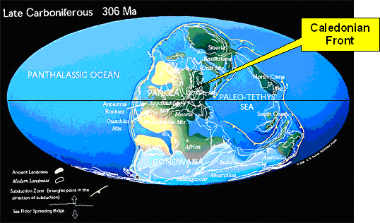
Paleogeographic reconstruction of the continents
during Late Carboniferous times showing the location
of the Caledonian front (from Scotese, 1997).
The Caledonian orogenic front in northwest Scotland was regarded as one of the most important targets for deep seismic profiling in the British Isles. The Caledonian foreland comprises Lewisan basement of highly deformed gneisses and granulites metamorphosed at about 2700 Ma (see map below). The foreland is sheared in a major thrust zone, the Outer Isles Thrust, one of the largest but least well-understood tectonic features of the British Isles (Brewer & Smythe, 1984). The Moine Schists were carried over the foreland along the Moine Thrust zone. There are various models for the structure of the region and the deep seismic profiling was employed to image the crustal structure. One of the key problems was to map the extent of foreland Lewisian basement under the orogen.
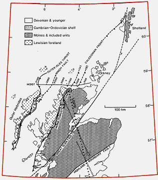
Location of the MOIST deep seismic profile northwest Scotland
and significant geological fault structure across
the region (from Brewer & Smythe, 1984).
The MOIST deep seismic profiling was conducted by Western Geophysical Company using a tuned 905cub.in. airgun array operating at 4,500psi at a depth of 12m and a 3km hydrophone streamer towed at a depth of 15m. The shot interval was 50m, sampling rate 4ms, record length 15s, and 30-fold sub-surface coverage (Smythe et al., 1982).
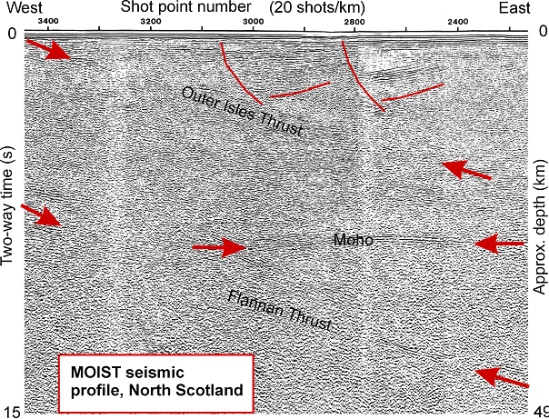
Part of the deep seismic reflection profile shot on the continental shelf
north of Scotland, March 1981 (from Brewer & Smythe, 1984).
The MOIST seismic profile produced some outstanding results in terms of imaging deep geological features:

Line diagram of the interpretation of the MOIST deep seismic profile
(from Brewer & Smythe, 1984).
The results from the MOST profile led to subsequent BIRPS deep seismic profiling work across northwest Scotland, e.g. DRUM profile and GRID profiles.
Brewer and Smythe (1984) interpreted the seismic data within the MOIST profile in terms of the structural geology across the region and made comparisons with the COCORP deep seismic profiling from the Appalachian Orogen of North America. They discuss MOIST and the continuity of crustal reflector geometry along the Caledonian Appalachian orogen:
New aspects of the deep structure of the Scottish Caledonides are revealed by the Moine and Outer Isles deep seismic reflection traverse (MOIST). The Caledonian foreland is underlain by an easterly dipping, strongly reflecting surface cutting through the Moho and traceable to more than 45 km depth. Thrusts within the foreland basement and Caledonian orogen have been reactivated as normal faults bounding half grabens filled with sediments of late Palaeozoic to Mesozoic age.
The Moine Thrust, which carries rocks of the orogen over Lewisian foreland, dips at 20 25' to the E on MOIST, and is either: (a) the westernmost of a series of easterly dipping reflections (thrusts) which flatten or terminate at 17 20 km depth, or (b) a thrust lying further E which structurally overlies these easterly dipping reflectors. By comparison with easterly dipping reflections on COCORP lines in the northern and southern Appalachians the latter interpretation is preferred, implying that many of the easterly dipping reflections on MOIST correspond to off shelf metasedimentary rocks, with slivers of basement, stacked and imbricated against the Lewisian basement edge.
Regional seismic refraction and conductivity data from northern Scotland suggest that regions of the Caledonian orogen have lower mid crustal velocity gradients and higher conductivities than the foreland, which might be explained by this interpretation of the easterly dipping reflections.
Despite similarities in crustal reflector geometries, there are important differences between the MOIST and COCORP lines, including (1) a remarkably continuous, relatively horizontal Moho seen on MOIST data at about 25 km depth, and (2) the sedimentary basins offshore from northern Scotland which have formed by reactivation under crustal extension of the easterly dipping thrusts. Furthermore, it is probable that the easterly dipping reflectors in these areas of the MOIST and COCORP lines were formed at different times in the early Palaeozoic.
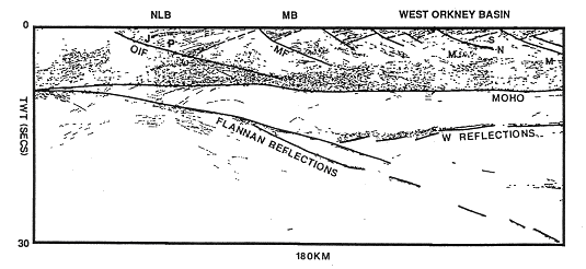
Line diagram of the DRUM line (Aug. 1984) 12-20km north of the
MOIST deep seismic profile with additional evidence for the nature of
crustal and upper mantle faulting north of Scotland (from Flack & Warner, 1990).
Wernicke (1984) gives an interpretation of the MOIST deep seismic profile in terms of whole lithosphere normal simple shear.
Marine deep-seismic reflection profiles from the British Isles acquired by the British Institutions' Seismic Reflection Profiling Syndicate (BIRPS) provide some of the best images to date of the deep structure of a zone of intra-continental extension. Simple quantitative considerations of finite strain indicate that the reflection geometry on the eastern half of the MOIST profile is consistent with the concept that large, low-angle normal faults persist as single zones of displacement through the entire lithosphere.
It is proposed that the lower crust absorbs displacement by the formation of a foliation parallel to the maximum elongation direction within finite width normal shear zones. In contrast, both up-dip and down-dip in stronger or more brittle layers, the shear zones not only narrow, causing foliation to become aligned with their boundaries, but they also absorb strain via a foliation comprised of discrete, boundary-parallel slip surfaces.
Such a geometry of through-going zones of displacement predicts non-alignment of lower crustal reflections with those in the mantle and upper crust within the same displacement zone. This model runs counter to current interpretations of deep reflection data that ascribe a more fundamental role to rheological stratification for the localization and development of zones of displacement in the lithosphere.
Brewer, J. A., and Smythe, D. K., 1984. MOIST and the continuity of crustal reflector geometry along the Caledonian-Appalachian orogen. Journal of the Geological Society of London, 141, 105-120.
Flack, C. and Warner, M., 1990. Three-dimensional mapping of seismic reflections from the crust and upper mantle, northwest of Scotland. Tectonophysics, 173, 469-481.
Smythe, D. K., Dobinson, A., McQuillin, R., Brewer, J. A., Matthews, D. H., Blundell, D. J. & Kelk, B., 1982. Deep structure of the Scottish Calodinides revealed by the MOIST reflection profile. Nature, 299, 338-340.
Scotese, C. R., 1997. Paleogeographic Atlas, PALEOMAP Progress Report 90-0497, Department of Geology, University of Texas at Arlington, Arlington, Texas, 37 pp.
Morgan, J. V., Hadwin, M., Warner, M. R., Barton, P. J., and. Morgan, R. P. L., 1994. The polarity of deep seismic reflections from the lithospheric mantle: Evidence for a relict subduction zone. Tectonophysics, 323, 319-328
Wernicke, B., 1984. Whole lithosphere normal simple shear: an interpretation of deep-reflection profiles in Great Britain. American Geophysical Union Geodynamics Series, Volume 14, 331-339.
[an error occurred while processing this directive]