Commemorating the
1st discovery of natural gas
in Australia [view larger image]
Updated: Dec 09, 2024
By D. M. Finlayson (Canberra) doug.finlayson@netspeed.com.au
Commemorating the
1st discovery of natural gas
in Australia [view larger image]
In the late 1940's Australia was still very poorly explored for natural resources and the Commonwealth and State governments of the day realised that the true mineral and oil/gas potential wealth of the country was yet to be determined. Gas resources had been discovered in Surat Basin in Queensland in 1900 but the true extent of the resource was yet unknown. The Commonwealth Government of the day decided that a major effort was required to systematically conduct geological mapping at 1:250,000 scale across the whole continent to encourage investment in mineral and oil/gas exploration by overseas and Australian companies.
At the same time the Commonwealth Government also initiated a program of systematic geophysical mapping including seismic reflection profiling across the country's sedimentary basins to encourage private exploration companies to compete for onshore mineral and hydrocarbon exploration leases that were constitutionally within the jurisdiction of the various State and Territory governments.
The Bureau of Mineral Resources, Geology and Geophysics (BMR) was established by the Australian Commonwealth Government in 1946 within the Department of National Development. There had been various predecessors formed by the Commonwealth Government with significant emphasis on geophysical methods prior to (and during) the 2nd world war in agencies called the Imperial Geophysical Experimental Survey, the Aerial, Geophysical and Geological Survey of Northern Australia and the Commonwealth Mineral Resources Survey (Wilkinson, 1996). The various BMR geological and geophysical groups with many staff drawn from the earlier Commonwealth Government agencies were initially based in Melbourne and Canberra but eventually they came together under one roof in central Canberra in 1965.
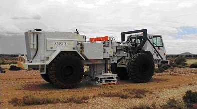
ANSIR vibrator seismic energy source "Brolga" – IVI Birdwagon Mk 4b
with Hemi-60 vibrator, 60,000 pounds pressure.
Usually 3 in line are used for routine deep seismic profiling.
As part of the Government policy to encourage private company exploration of Australia's onshore sedimentary basins for oil and gas resources, BMR, under the leadership of its Director Harold Raggatt (1946-51), formed a seismic exploration crew that began work in 1949. The main aim was to map sub-surface regional structures and sedimentary basin sequences across exploration lease boundaries and provide basic stratigraphic and structural information to exploration company seismic crews and basin geologists.
Thus began a seismic profiling programme by the Australian Commonwealth Government that continues to this day. BMR's successor organisations, Australian Geological Survey Organisation (AGSO) and Geoscience Australia (GA) (www.ga.gov.au) still supports a Commonwealth Government national seismic research facility, the Australian National Seismic Imaging Resource, (ANSIR) into the 21st century.
See a tutorial on seismic reflection profiling and a brief description of the Seismic Reflection Method.
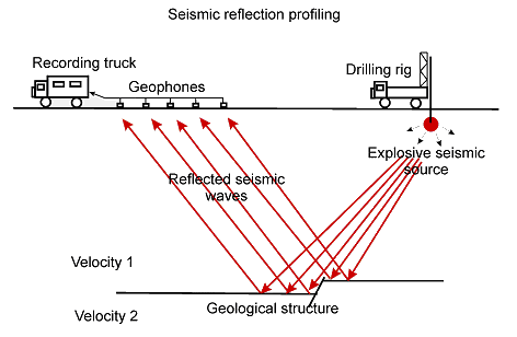
Profiling usually involved the use of explosive charges
in drill holes
as the seismic energy source
and this was the techniques used by the Australian BMR seismic crew(s).
Seismic profiling techniques within sedimentary basins during the 1940's – 1950's was not as sophisticated as it is today.
At that time most seismic reflection recording equipment was brought in from USA. Typical systems used by BMR in Australia incorporated the following components:
(TIC = Texas Instrument Company; HTL = Houston Technical Laboratories)
BMR seismologists at the time were aware of experimental deep seismic work being done in North America and Europe. BMR staff had also made wide-angle reflection seismic recordings from the Moho during atomic bomb tests in the South Australia desert areas during the 1950's and therefore knew that reflected energy was possible from throughout the entire Earth's crust. The example below from the 1953 Emu bomb test was made on standard exploration seismic equipment of the day and recorded on a 12-channel Century oscilloscope (Doyle, 1954).

Seismic waves reflected at a wide angle from the Moho (depth 37.2 km).
Seismic source: atomic explosion detonated 93.8km away at Emu Plains, 1953 (Doyle, 1954).
Later nuclear tests were also recorded during 1956 (Doyle, 1957). Records were made to at least 700km from the test site; an upper mantle (Pn) velocity of 8.18 km/s (corrected for Earth's curvature) and a depth to the Moho of 35±2km was determined. Later wide angle seismic profiling work using large chemical explosions in 1972 determined a Pn velocity of 8.23km/s across the Nullarbor Plain and a Moho depth ranging from 34-35km in the west near Kalgoorlie to 39-40km under the Maralinga nuclear bomb test site (Finlayson et al., 1974).
In various Australian sedimentary basins, at the end of BMR systematic field survey work for a season, experimental work was often undertaken by the seismic crews using larger shots to try to explore structures within the basement rocks to the sedimentary basins. Being single shot records however, meant that the true geological interpretation of such records was largely speculative at the time. However, on some surveys there were convincing recordings made of reflected energy from deep within basement rocks.
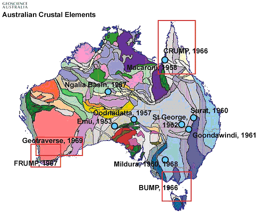
Sites of some of the 1950's and 1960's deep seismic crustal investigations
involving the Australian Bureau of Mineral Resources, Geology and Geophysics (BMR).
The BMR seismic profiling work in sedimentary basins as part of a national oil and gas search programme during the 1960's coincided with the Australian Academy of Science's involvement in the Upper Mantle Project (UMP), an initiative of the International Union of Geodesy and Geophysics (IUGG) from its 1960 meeting in Helsinki. The international academic community drew attention to the role that upper mantle processes played in forming and shaping near-surface geological features and the consequent implications for mineral and oil/gas resource exploration as well as natural hazard risk alleviation.
At that time "the knowledge and understanding of the upper mantle's physical and chemical constitution and of its complex dynamic behaviour remained at a comparatively primitive level." (, 1965). The prime objective of the project was to "remedy this situation" and gain a better understanding of the structure and geochemistry of the deeper Earth down to Moho depths and into the underlying upper mantle.
In Australia the Academy of Science formed an Australian Upper Mantle Committee (AUMC) convened by Prof. John Jaeger, Australian National University, and this committee developed a program of investigations that included seismic profiling of the Earth's crust to Moho depths at both wide-angle and near-vertical incidence.
In its first progress report (Ringwood, 1965) the AUMC recommended two major investigations:
Both these objectives were realised in the following 10 years and BMR was heavily involved in both.
The international Upper Mantle Project was also the catalyst for a series of wide-angle seismic profiling projects aimed at determining the basic seismic velocity features of the crust and upper mantle across Australia during the 1960's. BMR was heavily involved in three projects in continental Australia as well as seismic projects in Papua New Guinea:
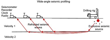
These UMP projects all used wide-angle seismic profiling techniques with shot-to-recorder distances of 100-300km to determine the P-wave seismic velocities within the crust and upper mantle and the depths to significant velocity changes down to at least the Moho. The projects contributed significant early data to the mapping of Moho depths across the Australian continent (Collins, 2003).
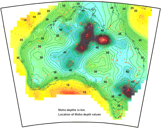
Moho depths contoured at 1km intervals
across the Australian region (Collins, 2003)
Deep seismic probes by BMR seismic crews during the 1950's encouraged the experimentation with various configurations of shot sizes, shot-hole patterns, geophone configurations and recording techniques.
Early BMR seismic crew in action.
[view larger image]
Much of the deep seismic reflection work during the 1950's and 1960's was aimed at improving the coupling of explosive sources with the ground, eliminating near-surface noise, and improving instrumentation and amplifiers. After the 1965 commitment of BMR to work on the Geotraverse in Western Australia, BMR invested considerable resources to perfecting their seismic reflection layouts and charge sizes for deep seismic work to obtain good results in hard rock terrains.
Up until 1959 all seismic reflection profiling was "single fold" recording made with multi-channel oscilloscope records. In 1959 BMR introduced magnetic recording on an Electro-Tech DS7/700 recorder. This enabled processing of seismic signals to enhance the signal-to-noise ratio and "stacking" signals in a computer to improve the signal-to-noise ratio prior to displaying the seismic record section. Digital data acquisition started in BMR for onshore surveys in 1976 with the purchase of a Texas Instruments DFS-IV 24-channel seismic recording system (DFS = digital field system).
The first attempt by BMR to record deep crustal reflections was at Oodnadatta in an area where good-quality sedimentary basin reflections had been recorded. A good quality event was recorded at 6.6 seconds two-way time (TWT) and an outstanding event at 12.2 seconds (Lodwick & Smith, 1962; Moss & Dooley, 1988).
During routine seismic reflection profiling in the Carpentarian Basin of northern Queensland, the BMR seismic crew made a single recording to 37 seconds near Macaroni. Probable deep reflections were recorded with apparent frequencies of 20-30 Hz at times from 3 to greater than 20 seconds (Robertson & Moss, 1959; Moss & Dooley, 1988). The most prominent late arrivals were at 7.1 seconds and at 11.8 seconds two-way time.
During 1960 BMR made extended recordings to 30 seconds two-way time. Significant events were recorded at 9.0, 10.9 and 11.9 seconds with apparent frequencies of 25 Hz (Moss & Dooley, 1988).
Consistent reflection seismic energy was recorded at 5.9, 10.3 and 12.4 seconds TWT (Moss & Dooley, 1988).
Atempts were made to record a continuous single-fold deep reflection profile with recordings from 12 consecutive shotpoints. High-amplitude event was recorded at 6.0 seconds TWT over most records and there was also a good-quality event at 10.1 seconds.
In the early 1960's there were still doubts about how useful the seismic profiling techniques used for oil and gas exploration would be at determining the structure of deeper basement rocks. In the Amadeus and Ngalia Basins of central Australia. experimentation was conducted to test seismic profiling techniques for penetrating basement rocks.
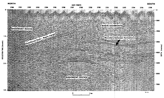
Reflection profile from the Ngalia Basin margin, central Australia 1968,
showing clear structural thrust features
within basement rocks of the upper crust (Moss & Jones, 1974)
On the northern margin of the Ngalia Basin BMR crews demonstrated in spectacular fashion that sedimentary layering could be imaged beneath overthrust basement rocks. The image above shows quite clearly an overthrust fault (reverse fault) placing basement rocks above the sedimentary sequences of the Ngalia Basin. Explosive seismic sources were used.
During routine seismic profiling in the Murray Basin near Mildura during 1960 two shots were recorded on a split-spread (Watson, 1962; Moss & Dooley, 1988). A prominent event was recorded at 10.2 seconds TWT on all traces from both shots, one recorded on 20 Hz geophones and the other on 6 Hz geophones. The two-way time of 10.2 seconds was exactly the same as that recorded eight years late during a more extensive seismic profiling survey (Branson et al., 1976).
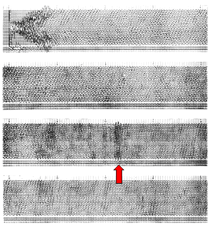
Strong reflected energy from the Moho at
about 10.2 seconds two-way time near Mildura, 1968 (Dooley, 1970)

Deep seismic reflections from a 12.5km reflection profile at Hines Hill (about 170km east of Perth)
on the Western Australian Geotraverse, 1969 (Mathur, Moss & Branson, 1977).
The Geotraverse was a broad-ranging earth science program to investigate the basic geological structure and geochemistry of an important Australian minerals province in Western Australia. Initiated by the Upper Mantle Project sub-committee of the Australian Academy of Science in 1965, it included components to study the geothermal history, the crustal and upper mantle structure, geochronology and the petrology/mineralogy/geochemistry along a 700km (approx.) transect from Perth to Coolgardie to the Great Australian Bight near Balladonia (east of Esperence). The Bureau of Mineral Resources, Geology and Geophysics (BMR), Canberra, played a key role in the investigation of crustal and upper mantle structure by geophysical methods (Ringwood, 1965).
Five areas along the Geotraverse were selected as sites for detailed seismic reflection probes (Fraser Range, Widgiemooltha, Boorabbin, Hines Hill and Wundowie). In addition wide-angle seismic profiling was undertaken along two transects, one between Coolgardie and Perth and the other between Perth and Albany (Mathur et al., 1977).
Collins, C. D. N., Drummond, B. J., and Nicoll, M. G., 2003. Crustal thickness patterns in the Australian continent. Geological Society of Australia Special Publication 22 and Geological Society of America Special Paper 372, 121-128.
Dooley, J. C., 1970. Seismological studies of the upper mantle in the Australian region. Proceedings of the Second Symposium on the Upper Mantle Project, December, 1970, Hyderabad, India, 113-146.
Doyle, H. A., 1954. Seismic investigations at the atomic explosion in South Australia, October, 1953. Bureau of Mineral Resources, Geology and Geophysics, Record 1954/64.
Doyle, H.A.,1957. Seismic recordings of atomic explosions in Australia. Nature, 180: 132 134.
Finlayson, D. M., 1968. First arrival data from the Carpentaria Region Upper Mantle Project (CRUMP). Journal of the Geological Society of Australia 15, 33-50.
Finlayson, D. M., Cull, J. P., and Drummond, B. J., 1974. Upper mantle structure from the Trans-Australia Seismic Survey (TASS) and other refraction data. Journal of the Geological Society of Australia, 21, 447-458.
Ringwood, A. E., 1965. Australian Progress Report, 1960-65, to the International Council of Scientific Unions Upper Mantle Project. Australian Academy of Science, Canberra, August 1965.
Mathur, S. P., Moss, F. J., and Branson, J., C., 1977. Seismic and gravity investigations along the Geotraverse, Western Australia, 1969. Bureau of Mineral Resources, Geology and Geophysics, Bulletin 191.
Moss, F. J., & Jones, P., 1974. Ngalia Basin seismic survey, Northern Territory. Bureau of Mineral Resources, Geology and Geophysics, Australia, Record 1974/49.
Underwood, R., 1969. A seismic refraction study of the crust and upper mantle in the vicinity of the Bass Strait. Australian Journal of Physics, 22, 573-587.
[an error occurred while processing this directive]