Updated: Dec 09, 2024
During the 1950's atomic weapons tests were conducted in Australia at a test site called Emu Plains (near Woomera, South Australia). The weapons were tested above ground either mounted on a tower or suspended from a balloon.
The seismic waves from these explosions were recorded by staff from the Australian Commonwealth Government Bureau of Mineral Resources, Geology and Geophysics (BMR) at various sites in South Australia and Western Australia. These recordings were among the earliest to record P-waves reflected from the Moho - the crust/mantle boundary.

Thus, by the 1950's it was known that crude reflection profiling methods could be used to determine the structure of the Earth's crust.
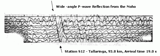
The record (see image) was made using a Century 24 channel exploration seismograph recording on photographic paper running at 180 mm/s. The equipment was located at Tallaringa, about 93.8 km to the east of the Emu test site. The seismic source was a 1953 atomic test. From the results the depth to the crust/mantle boundary (the Moho) was estimated at 37 km but with a higher value for the P-wave velocity for the crust this would increase to 38-39 km. The prominence of the wide-angle reflection was interpreted to be evidence of a sharp transition from crustal to upper mantle rocks.
Further seismic recordings of atomic tests were conducted at a number of sites in southern Australia during 1956 and 1957.
More recent data from the region indicate a Moho depth of 39 km under the Emu Plains area using a more detailed model of crustal velocities (Finlayson, Cull & Drummond, 1974).
Doyle, H. A. & Everingham, I. B., 1964. Seismic velocities and crustal structure in southern Australia. Journal of the Geological Society of Australia, 11, 141-150
Finlayson, D. M., Cull, J. P., & Drummond, B. J., 1974. Upper mantle structure from the Trans-Australia Seismic Survey (TASS) and other seismic refraction data. Journal of the Geological Society of Australia, 21, 447-458.
[an error occurred while processing this directive]