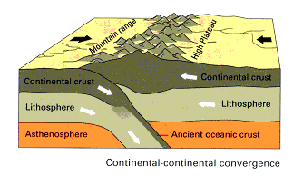
Fig. 1 - Schematic continent-continent collision zone and orogenic belt (Kious & Tilling, 1996)
Updated: Dec 09, 2024
Compiled by Doug Finlayson
The Uralian orogen of central Russia marks the Late Palaeozoic collision of the East European craton with the Siberian craton and intervening terranes of oceanic, island arc and micro-continental origin (Juhlin et al., 1996).
Fig. 1 - Schematic continent-continent collision zone and orogenic belt (Kious & Tilling, 1996)
The Urals evolved as an orogen throughout the Palaeozoic era as a part of the Palaeozoic supercontinent Pangea. Rifting and development of a passive continental margin on the East European Platform started in the latest Cambrian to Early Ordovician time. Middle Palaeozoic time was characterised by rifting of micro-continental fragments, formation of island arcs and back-arc basins, and then the collisional assembly of these terranes within the Uralian paleo-ocean. Final closure of the basin took place in Late Carboniferous and Permian time ( Juhlin et al., 1995).

Fig. 2 - Distribution of continental land masses
during Early Carboniferous times (356 Ma before present).
Note the location of the Ural Mountains terrane (Scotese, 1997).
Unlike other major orogens of Palaeozoic age (Appalachians, Variscides, Caledonides) that have undergone post-orogenic tectonic episodes, the Uralian orogen is an intact example of a Palaeozoic continental collision and, for this reason, constitutes a unique place in which to study process of continental evolution (Juhlin et al., 1996). The Ural Mountains are taken to be the boundary between Europe and Asia and are a large source of mineral wealth for Russia.
The Ural Mountains extend for more than 2000 km from the Barents Sea in the north to the Caspian Sea in the south and separate the Russian Platform from the West Siberian lowlands (Kruse & McNutt, 1988).(Fig. 3)
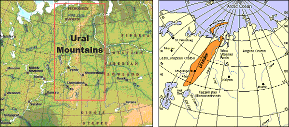
Fig. 3 - Location map.
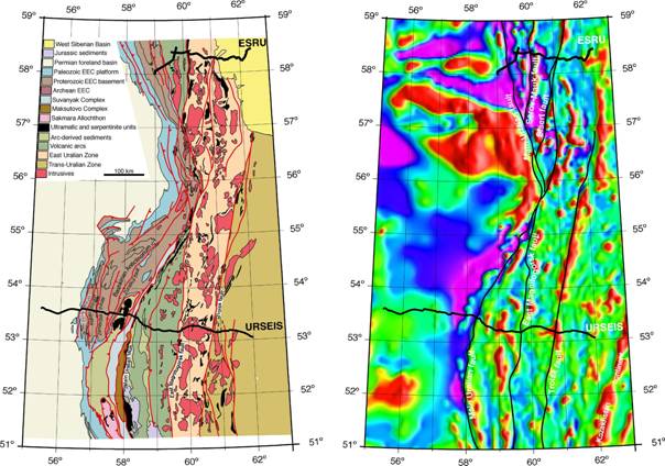
Fig. 4 – Geological and aeromagnetic images of the Ural Mountains region showing
the locations of ESRU and URSEIS seismic profiles (Carbonell & Brown, 2005)
One of the most intriguing and fundamental aspects of the Urals is the presence of a pronounced crustal root beneath the orogen, identified as a seismic velocity feature by wide-angle deep seismic profiling work during the early 1990's. The root is characterised by its high average P-wave velocity (7.2 - 7.8 km/s) and varies in thickness from 5 to 20 km. The underlying upper mantle is characterised by high average P-wave velocities of 8.3-8.4 km/s. The presence of the root is consistent with the preservation of the Urals as an intact, unextended orogen, but not consistent with the relatively subdued topography (1.8 km maximum elevation) and relatively small amplitude Bouguer gravity anomaly (approx. -30 mGal) (Juhlin et al., 1996).
The P-wave seismic velocity structure through the central part of the Ural Mountains is shown in Figure 5. This velocity structure is a re-interpretation of wide-angle seismic profiling data collected prior to 1990. The main features of the velocity model are, a) a lower crustal root with its deepest point under the Main Uralian Fault (MUF), b) the comparatively high upper mantle velocities (8.4-8.5 km/s), c) very high lower crustal velocities (7.6-7.8 km/s) below the Urals, and d) a possible low velocity zone at mid crustal depths of 20-30 km (Juhlin et al., 1996).
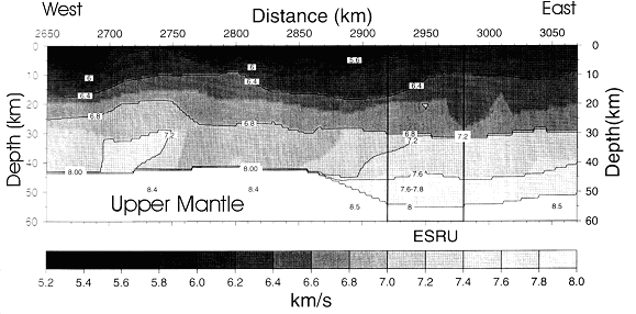
Fig. 5 - Seismic P-wave velocity model through the Ural Mountain region (Juhlin et al., 1996).
The 1995 URSEIS project in the southern Ural Mountains also highlighted a crustal root beneath the central part of the orogen from wide-angle seismic profiling work (Carbonell et al., 1996). This crustal root was interpreted to be 12-15 km thick. The Moho depth varies between 42 and 45 km to the east and western ends of the URSEIS profile and between 55 and 60 in the centre. The upper mantle P-wave velocities are in the range 8.0-8.2 km/s and S-wave velocities are 4.5-4.7 km/s.
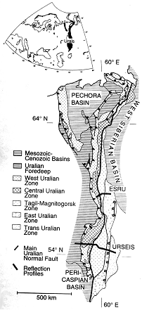
Fig. 6 - Regional geology of the Urals Mountain area and the location
of the ESRU and URSEIS deep seismic profiling (Juhlin et al., 1998).
During the period 1993-96, deep seismic common mid-point (CMP) reflection profiling data were acquired along several traverses totalling about 190 km in the central part of the Ural Mountains (Europrobe Seismic Reflection Profile in the Urals, ESRU) (Figs. 4, 6). Dynamite seismic sources were used (20-45 kg shots at 100-150m spacing); number of channels varied from 96 (split spread); nominal fold 15-48; sample rate 4ms; record length 25-59 seconds (Juhlin et al., 1998).
The main features observed in the ESUU data are the east-dipping Main Uralian Fault (MUF) and related faults in the west and the through-going west-dipping Trans-Uralian Thrust Zone in the east (Figs. 7 & 8). Many upper crustal reflective elements can be correlated confidently with significant faults and geological boundaries at the surface. With the exception perhaps of the Trans-Uralian Thrust Zone (TUTZ), most faults appear to be listric and are truncated at middle to lower crustal levels. The TUTZ (probably Late Permian age) may penetrate the entire crust. The lower crustal reflectivity in the west is probably a pre-Uralian feature of the East European Craton. Crustal thickness is about 45 km in the east and west but beneath the central axis of the Ural Mountains is 53-55 km based on wide-angle seismic profiling (Juhlin et al., 1998).
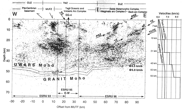
Fig. 7 - Deep seismic reflection profiling image and velocity/depth profile of the Earth's crust
under the Ural Mountains, Central Asia from ESRU data (Juhlin et al., 1998).
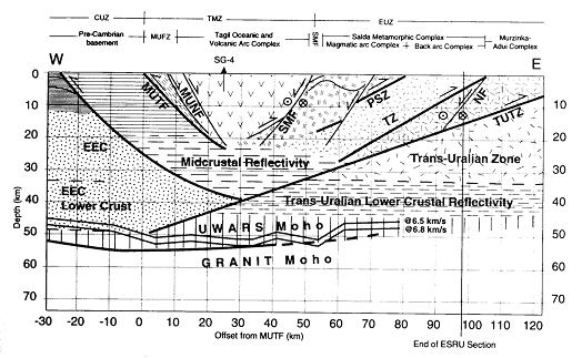
Fig. 8 - Interpretation diagram of main geological units and boundaries interpreted from ESRU data
in the central part of the Ural Mountains. CUZ = Central Uralian Zone; EUZ = East Uralian Zone;
MUTF = Main Uralian Thrust Fault; MUNF Main Uralian Normal Fault; PSZ = Prianitchnikova Shear Zone;
SMF = Serov Mauk Fault; TMZ = Tagil Magnitogorsk Zone; TUTZ = Trans-Uralian Thrust Zone (Juhlin et al 1998).
During 1995 Project URSEIS (Urals Reflection Seismic Experiment and Integrated Studies) acquired seismic reflection profiling data (with both vibroseis and dynamite sources) and wide-angle seismic data along a 450 km transect of the southern Ural Mountains (Fig. 4, 6). These data provide a complete seismic image of the crustal and upper mantle architecture of an intact Palaeozoic continental collision.
An Input-Output II telemetric digital recording system was used (360 channels, 50 m group interval, 2.7 km of roll along capacity) with explosive seismic sources (20-160 kg). Far offsets were up to 18 km; nominal 6 fold CMP). Record lengths were 68 seconds at 4 ms sampling rate (Steer et al., 1998). Vibroseis source profiling was also conducted along the URSEIS transect to obtain high resolution images of fault structures and terrane boundaries within the crust of the southern Ural Mountains (Fig. 8).
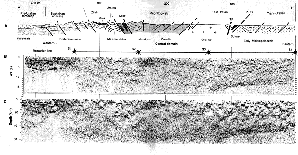
Fig. 9 - Simplified tectonic, and geologic across the southern Ural Mountains along the URSEIS 95 vibroseis profile.
B - unmigrated vibroseis crustal image data; C - migrated and depth converted vibroseis data (Echtler et al., 1996)
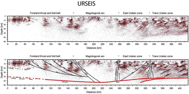
Fig. 10 - Colour image of the URSEIS deep seismic profile together with interpretation of tectonic architecture
of the Earth's crust in the southern Ural Mountains (Carbonell & Brown, 2005)
Along the URSEIS profile, the upper crust of the Trans-Uralian zone is dominated by discontinuous , east-dipping reflections and diffractions to a depth of about 20 km. The middle and lower crust is dominated by west-dipping reflections (30-40 deg.) that can be traced from supracrustal levels to a depth of about 40 km. These west-dipping reflections project to the surface and correlate with shear zones within Palaeozoic island arcs and oceanic terranes implying an east-vergent, thick-skinned thrust stack. The continuous west-dipping events merge downward, with a narrow subhorizontal zone that dips westward from 40 to 55 km depth (Echtler et al., 1996).
The URSEIS data display a marked variability in the character of the Moho along the profile. The uppermost mantle is largely non-reflective. In the Trans-Uralian Zone, the preservation of dipping reflections through the entire crustal column is evidence that little or no extension occurred in this region and supports the hypothesis that the merging reflections at the Moho formed during tectonic assembly with the Moho acting as a detachment (Steer et al., 1998)
The URSEIS seismic reflection profiling in the southern Ural Mountains also recorded data from the upper mantle beneath the Earth's crust. The two-way time (TWT) to these reflections is 22-24 seconds, i.e. features at 80-100 km depth. These reflections may represent a continuation of the Main Uralian Fault (MUF) into the sub-crustal lithosphere (Steer et al., 1998). Deeper reflections at 35-45 seconds TWT (140-160 km depth) and 55 seconds TWT (225 km depth) may image mafic intrusions near the base of the lithosphere or along localised shear zones in the upper mantle (Fig. 11).
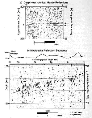
Fig. 11 - Deep mantle reflections from the southern Ural Mountains (Steer et al., 1998)
The reflective crustal section is characterised by dipping, crustal-scale shear zones and a pronounced crustal root that show no evidence of overprinting by extension and are preserved since late Palaeozoic collision. Towards the east, the Uralian crustal root is composed of a partially subducted volcanic arc, while to the west it has affinity with the East European platform. The reflection character of the Moho varies across tectonic strike and implies that the Moho (1) acted as a detachment beneath the Trans-Uralian Zone, (2) forms a tectonic boundary between terranes beneath the East Uralian Zone, (3) consists of a transitional zone from eclogitized lower crust to perodititic upper mantle in the crustal root, (4) is a 3-9 km thick reflective zone beneath the fold and thrust belt, and (5) is a boundary less than 200 m thick in the west (Steer et al., 1998).
The seismic data across the central and southern Ural Mountains strongly indicate that lithosphere in the region is that of an intact collisional orogen with a pronounced crustal root under its axis preserved since Palaeozoic time (Berzin et al., 1996). Figure 12 give an interpretation of the geological history of the orogen (Friberg et al., 2002).
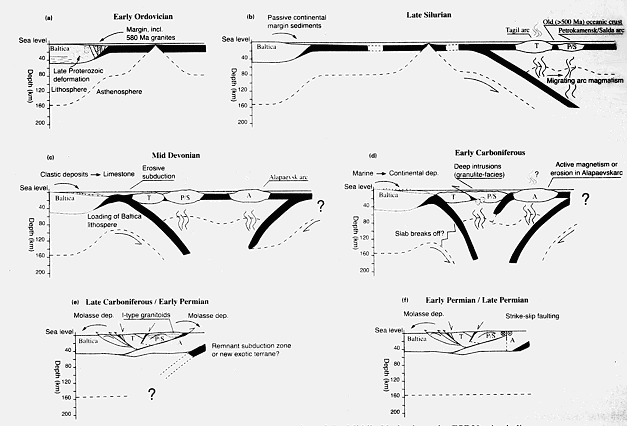
Fig. 12 - Suggested Palaeozoic tectonic evolution of the Middle Urals along the ESRU seismic lines (Friberg et al., 2002).
http://www-app1.gfz-potsdam.de/www/pb3/dekorp/urseis.html
http://www.geo.cornell.edu/geology/urseis/WWW_URSEIS.html
http://www.geofys.uu.se/eprobe/Projects/uralides/Uralides.htm
The compiler of this brief description freely acknowledges the copyright on the scientific papers by the authors attributed in the text and figure captions and of the publishers of these scientific papers. Text passages quoted and figures used from these papers are made within the "fair dealing" and the "fair use" provisions for "research and study" and for "criticism and review" within the copyright laws of Australia, other common law jurisdictions, countries of the European Union and the USA. Any copyright issues arising from this web page should be brought to the attention of Dr. D. M. Finlayson (doug.finlayson@netspeed.com.au ), Business Manager, IGCP Project 474.
Ayarza P., Juhlin C., Brown D., Beckholmen M., Kimbell G., Pechning, R., Pevzner, L., Pevzner, R., Ayala C., Bliznetsov, M., Glushkov A. and Rybalka A., 2000, Integrated geological and geophysical studies in the SG4 borehole area, Tagil Volcanic Arc, Middle Urals: Location of seismic reflectors and source of the reflectivity, J. Geophys. Res., 105, 21333-21352.
Berzin, R., Oncken, O., Knapp, J. H., Perez-Estaun, A., Hismatulin, T., Yunusov, N. & Lipilin, A., 1996. Orogenic evolution of the Ural Mountains: results from an integrated seismic experiment. Science, 274, 220-221.
Brown D., Juhlin C., Tryggvason A., Steer D., Ayarza P., Beckholmen M., Rybalka A. and Bliznetsov M., 2002, The Crustal Architecture of the Southern and Middle Urals from the URSEIS, ESRU, and Alapaev Reflection Seismic Profiles, in Orogenic Processes in the Paleozoic Uralides, Geophysical Monograph Series, AGU, 33-48.
Brown D., Juhlin C., Alvarez-Marron J., Pérez-Estaún A., and Oslianski A., 1998, The crustal-scale structure and geodynamic evolution of an arc-continent collision zone in the southern Urals, Russia, Tectonics, 17(2), 158-170.
Carbonell, R., Perez-Estaun, A., Gallart, J., Diaz, J., Kashubin, S., Mechie, J., Stadtlander, R., Schulze, A., Knapp, J. H. & Morozov, A., 1996. Crustal root beneath the Urals: wide-angle seismic eveidence. Science, 274, 222-224
Carbonell, R. & Brown, D., 2005. URSEIS'95: A multi-seismic study across the southern Ural Orogen. In: Abstracts of the Supercontinents and Earth Evolution Symposium (Eds. Wingate, M. T. D. & Pisarevsky, S. A.), Geological Society of Australia Abstracts No. 81, 63.
Echtler, H. P., Stiller, M., Steinhoff, F., Krawczyk, C., Suleimanov, A., Spiridonov, V., Knapp, J. H., Menshikov, Y., Alvarez-Mrron, J. & Yunusov, N., 1996. Preserved collisional crustal structure of the Southern Urals revealed by Vibroseis profiling. Science, 274, 224-226.
Friberg M., Juhlin C., Beckholmen M., Petrov G.A. and Green A. G., 2002, Palaeozoic tectonic evolution of the Middle Urals in the light of the ESRU seismic experiments, J. Geol. Soc. London, 159, 295-306.
Juhlin, C., Knapp, J. H., Kashubin, S. & Bliznetsov, M., 1996. Crustal evolution of the Middle Urals based on seismic reflection and refraction data. Tectonophysics, 264, 21-34.
Juhlin, C., Kashubin, S., Knapp, J. H., Makovsky, V., & Ryberg, T., 1995. Project conducts seismic reflection profiling in the Ural Mountains. EOS Transactions of the American Geophysical Union, 76, 193-198.
Juhlin C., Friberg M., Echtler H., Hismatulin T., Rybalka A., Green A.G. and Ansorge J., 1998, Crustal structure of the Middle Urals: results from the ESRU experiments, Tectonics, 17(5), 710-725.
Kious, W. J., & Tilling, R. I., 1996 This Dynamic Earth: the Story of Plate Tectonics. U.S. Geological Survey, Denver, Colorado, General Interest Publication.
Knapp, J. H., Steer, D. N., Brown, L. D., Berzin, R., Suleimanov, A., Stiller, M., Luschen, E., Brown, D. L., Bulgakov, R., Kashubin, S. N. & Rybalka, A. V., 1996. Lithsphere-scale seismic image of the southern Urals from explosion-source reflection profiling. Science, 274, 226-228.
Kruse, S. & McNutt, M., 1988. Compensation of Paleozoic orogens: a comparison of the Urals to the Appalachians. Tectonophysics, 154, 1-17.
Scotese, C. R., 1997. Paleogeographic Atlas, PALEOMAP Progress Report 90-0497, Department of Geology, University of Texas at Arlington, Arlington, Texas, 37 pp.
Steer, D. N., Knapp, J. H., Brown, L. D., Echtler, H. P., Brown, D. L., & Berzin, R., 1998. Deep structure of the continental lithosphere in an unextended orogen: An explosive source seismic reflection profile in the Urals (Urals Seismic Experiment and Integrated Studies (URSEIS 1995)), Tectonics, 17, 143-157.
Tryggvason, A., Brown, D. & Perez-Estaun, A., 2001. Crustal architecture of the southern Uralides from true amplitude processing of the URSEIS vibroseis profile, Tectonics, 20, 1040-1052.
C. Juhlin - Department of Geophysics, Uppsala University, Villavagen 16, S-75236, Uppsala, Sweden.
J. H. Knapp - Department of Geological Sciences, University of South Carolina, 701 Sumter Street, Columbia, South Carolina 29208, USA.
S. Kashubin - Bazhenov Geophysical Expedition, Ural Geological Commission, Scheelit, Sverdlovsk District 624051, Russia
L. D. Brown - Institute for Study of the Continents (INSTOC), Cornell University, Ithaca, NY 14853, USA.
R. Carbonell - Instituto de Ciencias de la Terra, Cosejo Superior de Investigaciones Cientificas, Barcelona, 08028 Spain
[an error occurred while processing this directive]