[an error occurred while processing this directive]
[an error occurred while processing this directive]
Updated: Dec 09, 2024
IGCP Project 559 - Seismic Images
Crustal Architecture of the East African Rift System
A review compiled by doug.finlayson@netspeed.com.au
Kenya Rift International Seismic Project (KRISP)
Background
The East African Rift is the largest continental rift system on Earth. It extends from Lebanon in the north, along the Red Sea and through Sudan, Ethiopia, Kenya, Tanzania to Mozambique. A number of web sites with articles/papers/information on the rift are presented in:
http://www.geolor.com/East_African_Rift_Valley_geolor.htm
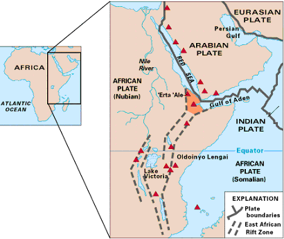
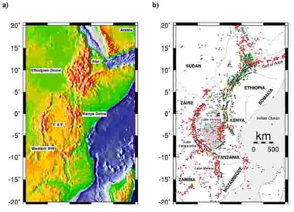
Map of East Africa showing some of the historically active volcanoes (red triangles)
and the Afar Triangle (shaded, centre) — a so-called triple junction (or triple point),
where three plates are pulling away from one another: the Arabian Plate,
and the two parts of the African Plate (the Nubian and the Somalian)
splitting along the East African Rift Zone. (US Geological Survey)
http://pubs.usgs.gov/gip/dynamic/dynamic.html
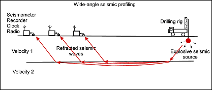
Most of the seismic investigations of crustal structure within the rift system to date have involved wide-angle seismic profiling with shot-to-recorder offsets of more than 400-700 km in places.
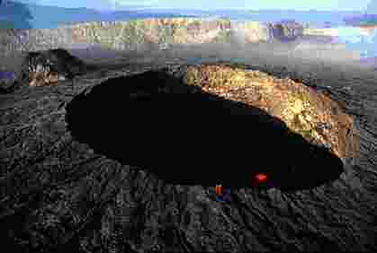
Helicopter view (in February 1994) of the active lava lake within the summit crater of 'Erta 'Ale (Ethiopia),
one of the active volcanoes in the East African Rift Zone. Two helmeted, red-suited volcanologists — observing
the activity from the crater rim — provide scale. Red color within the crater shows where molten lava is breaking
through the lava lake's solidified, black crust. (Photograph by Jacques Durieux, Groupe Volcans Actifs.) .
(US Geological Survey) http://pubs.usgs.gov/gip/dynamic/dynamic.html
Kenya Rift International Seismic Project (KRISP)
The acronym KRISP is the name give to a series of crustal investigations that have been conducted by research institutions from Germany, UK, USA, Ireland and Kenya in the period 1985 to 1995. Three phases of the field work are identified as KRISP85, KRISP90 and KRISP94.
The abstracts from selected key papers in the journal Tectonophysics resulting from the KRISP project(s) are set out below.
Crustal structure beneath the Kenya Rift from axial profile data
J. Mechie, G. R. Keller, C. Prodehl, S. Gaciri, L. W. Braile, W. D. Mooney, D. Gajewski and K. -J. Sandmeier
(from Tectonophysics, 1994, vol. 236, pages 179-200)
Modelling of the KRISP 90 axial line data shows that major crustal thinning occurs along the axis of the Kenya Rift from Moho depths of 35km in the south beneath the Kenya Dome in the vicinity of Lake Naivasha to 20 km in the north beneath Lake Turkana. Low Pn velocities of 7.5–7.7km/s are found beneath the whole of the axial line.
The results indicate that crustal extension increases to the north and that the low Pn velocities are probably caused by magma (partial melt) rising from below and being trapped in the uppermost kilometres of the mantle.
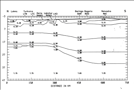
P-wave velocity model of the Earth's crust along the axis of the East African Rift in Kenya. Velocities in km/s; depths in km.
Along the axial line, the rift infill consisting of volcanics and a minor amount of sediments varies in thickness from zero where Precambrian crystalline basement highs occur to 5–6km beneath the lakes Turkana and Naivasha. Analysis of the Pg phase shows that the upper crystalline crust has velocities of 6.1–6.3km/s. Bearing in mind the Cainozoic volcanism associated with the rift, these velocities most probably represent Precambrian basement intruded by small amounts of igneous material. The boundary between the upper and lower crusts occurs at about 10km depth beneath the northern part of the rift and 15km depth beneath the southern part of the rift. The upper part of the lower crust has velocities of 6.4–6.5km/s. The basal crustal layer which varies in thickness from a maximum of 2km in the north to around 9km in the south has a velocity of about 6.8km/s.
A crustal and uppermost mantle cross-sectional model of the Kenya Rift derived from seismic and gravity data
P. K. H. Maguire, C. J. Swain, R. Masotti and M. A. Khan
(from Tectonophysics, 1994, vol. 236, pages 217-249)
The most significant implication of a combined seismic and gravity model derived from the data along the KRISP 90 cross-rift line on the Equator concerns the compensation mechanism for the uplifted East African plateau. The seismic model shows that despite an elevation difference of 400m the thickness of the crust at both ends of the profile is approximately the same at about 34km below sea level. A regional gradient needs to be added to the gravity field calculated from the seismic model to agree with the observed. This regional is consistent with Ebinger et al.'s (1989) proposal that the plateau is being dynamically supported by convective processes in the mantle.
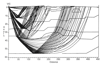
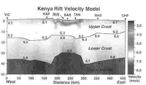
An example of seismic ray modelling to match observed seismic P-wave travel-times from
the Lake Victoria shot point along an East-West profile across the East African Rift in Kenya.
P-wave velocities within the Earth's crust and upper mantle along an East-West profile across the Kenya rift.
The principal features revealed by the seismic modelling are:
- The presence of the thick graben infill, and in particular a very deep (8 km below sea level) low-velocity body beneath the Kerio Valley adjoining the rift's western boundary, the Elgeyo fault.
- The correlation between seismic velocities in the upper crust and different Precambrian (Archaean and Pan-African Mozambique orogenic belt) crustal packages identified along the profile.
- A thickening of the crust beneath both margins of the rift.
- The apparent symmetry in crustal thinning mirroring the surface distribution of Tertiary volcanics and sediments, suggesting a pure shear mechanism of crustal extension.
- The presence of a wide, anomalously low-velocity (7.6–7.8km s-1) body at the base of the crust identified along the axial line and which it has been argued must include partial melt. This may be continuous with a deep low-velocity zone beneath the rift previously identified from the study of teleseismic residuals.
- The presence of an intra-mantle reflector at a depth of approximately 55 km beneath the western margin of the rift.
Deep seismic sounding in the Turkana depression, northern Kenya Rift
Dirk Gajewski, Andreas Schulte, Don Riaroh and Hans Thybo
(from Tectonophysics, 1994, vol. 236, pages 165-178)
Existing models of the structure and evolution of the Kenya Rift such as pure shear lithospheric extension, extension by simple shear or rift development by diapiric upwelling of an asthenolith, were based upon surface geology and a few geophysical (mainly gravity and seismic) data sets. Since the knowledge of the lithospheric structure plays an important role to distinguish between these different models, the Kenya Rift International Seismic Project was conducted in 1990 in the area of the Kenya Rift.
The project involved a detailed multi-fold refraction wide-angle reflection line in the northern Kenya Rift along the western shore of Lake Turkana which is the most prominent feature of the so-called Turkana depression. Under-water explosions were used as sources and a good signal-to-noise ratio was obtained allowing the identification of arrivals from the crust and upper mantle.
The most important result of modelling the data is a crustal thickness of 21km in the area of Lake Turkana, whereas in the area of the Kenya dome the crustal thickness is 34km. This points to an extension not previously expected in the northern Kenya Rift. The Moho discontinuity appears as a transition zone in the northern part of the profile, whereas in the southern part it changes to a first-order discontinuity. The largest vertical and lateral heterogeneities are observed in the rift infill displaying basins of varying thickness. The upper and lower crust which are separated by the Conrad discontinuity (the velocity changes from 6.2 to 6.4km/s here) show very little lateral heterogeneity. The P-wave velocity in the upper mantle was modelled to be 7.7km/s and thus can be distinguished from that in the southern Kenya Rift, where a velocity of 7.5km/s was observed. The crustal structure of the graben supports a model of a southerly propagation of the rift.
Seismic structure of the uppermost mantle beneath the Kenya rift
G. R. Keller, James Mechie, L. W. Braile, W. D. Mooney and Claus Prodehl
(from Tectonophysics, 1994, vol. 236, pages 201-216)
The major goal of the Kenya Rift International Seismic Project (KRISP) 1990 experiment was the determination of deep lithospheric structure. In the refraction/wide-angle reflection part of the KRISP effort, the experiment was designed to obtain arrivals to distances in excess of 400km. Phases from interfaces within the mantle were recorded from many shotpoints, and by design, the best data were obtained along the axial profile. Reflected arrivals from two thin (< 10km), high-velocity layers were observed along this profile and a refracted arrival was observed from the upper high-velocity layer. These mantle phases were observed on record sections from four axial profile shotpoints so overlapping and reversed coverage was obtained.
Both high-velocity layers are deepest beneath Lake Turkana and become more shallow southward as the apex of the Kenya dome is approached. The first layer has a velocity of 8.05–8.15km/s, is at a depth of about 45km beneath Lake Turkana, and is observed at depths of about 40km to the south before it disappears near the base of the crust. The deeper layer has velocities ranging from 7.7 to 7.8km/s in the south to about 8.3km/s in the north, has a similar dip as the upper one, and is found at depths of 60–65 km. Mantle arrivals outside the rift valley appear to correlate with this layer.
The large amounts of extrusive volcanics associated with the rift suggest compositional anomalies as an explanation for the observed velocity structure. However, the effects of the large heat anomaly associated with the rift indicate that composition alone cannot explain the high-velocity layers observed. These layers require some anisotropy probably due to the preferred orientation of olivine crystals. The seismic model is consistent with hot mantle material rising beneath the Kenya dome in the southern Kenya rift and north-dipping shearing along the rift axis near the base of the lithosphere beneath the northern Kenya rift. This implies lithosphere thickening towards the north and is consistent with a thermal thinning of the lithosphere from below in the south changing to thinning of the lithosphere due to stretching in the north.
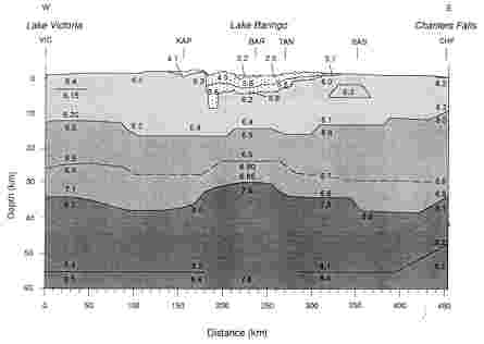
Modelling the 2-D seismic velocity structure across the Kenya rift
L. W. Braile, B. Wang, C. R. Daudt, G. R. Keller and J. P. Patel
(from Tectonophysics, 1994, vol. 236, pages 217-249)
A 460-km-long seismic refraction/wide-angle reflection profile across the East African rift in Kenya has been interpreted using a travel-time inversion method to calculate a two-dimensional crustal and uppermost mantle seismic velocity model. The derived model is consistent with the crustal structure determined by independent interpretation of axial (along the rift) and flank (near the eastern end of the cross profile) data sets.
P-wave velocity model across the East African Rift in Kenya at about the Equator. Velocities in km/s;depths in km.
The velocity model highlights the following features of the Kenya rift at this location (near the Equator):
- A relatively narrow (about 100km wide) feature from surface expression (fault-bounded basins) to upper-mantle depths.
- A 5km-deep, sediment- and volcanic-filled basin is present beneath the rift valley.
- Seismic velocities in the underlying crust are slightly higher directly beneath the rift valley than in the adjacent terranes.
- The crust thins by about 8km (to a thickness of about 30km) in a 100-km-wide zone beneath the rift valley.
- Anomalously low upper-mantle seismic velocity (Pn " 7.6km/s) is present only beneath the thinned crust and extends to depths of greater than 120 km.
The East African rift system in the light of KRISP 90
G. R. Keller, C. Prodehl, J. Mechie, K. Fuchs, M. A. Khan, P. K. H. Maguire, W. D. Mooney, U. Achauer, P. M. Davis, R. P. Meyer, L. W. Braile, I. O. Nyambok and G. A. Thompson
(from Tectonophysics, 1994, vol. 236, pages 465-483)
On the basis of a test experiment in 1985 (KRISP 85) an integrated seismic–refraction/teleseismic survey (KRISP 90) was undertaken to study the deep structure beneath the Kenya rift down to depths of 100–150km. This paper summarizes the highlights of KRISP 90 as reported in this volume and discusses their broad implications as well as the structure of the Kenya rift in the general framework of other continental rifts.
Major scientific goals of this phase of KRISP were to:
- Reveal the detailed crustal and upper mantle structure under the Kenya rift.
- Study the relationship between mantle updoming and the development of sedimentary basins and other shallow structures within the rift.
- Understand the role of the Kenya rift within the Afro-Arabian rift system and within a global perspective.
- Elucidate fundamental questions such as the mode and mechanism of continental rifting.
The KRISP results clearly demonstrate that the Kenya rift is associated with sharply defined lithospheric thinning and very low upper mantle velocities down to depths of over 150 km. In the south-central portion of the rift, the lithospheric mantle has been thinned much more than the crust. To the north, high-velocity layers detected in the upper mantle appear to require the presence of anistropy in the form of the alignment of olivine crystals. Major axial variations in structure were also discovered, which correlate very well with variations in the amount of extension, the physiographic width of the rift valley, the regional topography and the regional gravity anomalies. Similar relationships are particularly well documented in the Rio Grande rift.
To the extent that truly comparable data sets are available, the Kenya rift shares many features with other rift zones. For example, crustal structure under the Kenya, Rio Grande and Baikal rifts and the Rhine Graben is generally symmetrically centered on the rift valleys. However, the Kenya rift is distinctive, but not unique, in terms of the amount of volcanism. This volcanic activity would suggest large-scale modification of the crust by magmatism. Although there is evidence of underplating in the form of a relatively high-velocity lower crustal layer, there are no major seismic velocity anomalies in the middle and upper crust which would suggest pervasive magmatism. This apparent lack of major modification is an enigma which requires further study.
A model for the structure, composition and evolution of the Kenya rift
J. Mechie, G. R. Keller, C. Prodehl, M. A. Khan and S. J. Gaciri
(from Tectonophysics, 1997, vol. 278, pages 95-119)
The seismic refraction-wide-angle reflection experiments carried out in 1985 and 1990 in the Kenya rift (KRISP '85 and KRISP '90) show major crustal thickness variations both along and across the rift.
Along the rift axis crustal thickness varies from 35 km in the south beneath the Kenya dome to 20km in the north beneath the Turkana region. Due to the distribution of crustal thickness beneath the rift flanks, it can be stated that the major amount of variation in crustal thickness along the rift axis is due to the Tertiary rifting episode. The northwards decrease in crustal thickness can be correlated with changes in surface topography (northwards decrease), rift width (northwards increase), surface estimates of extension (5–10km in the south and 35–40km in the north) and Bouguer gravity, the regional northwards increase of which can be explained entirely by the change in crustal thickness.
Below the 750 km long axial rift profile, uppermost mantle Pn velocities are low, being 7.5–7.7km/s. However, under the northern part of the rift two layers with velocities of 8.1km/s and 8.3km/s are embedded in the low-velocity mantle material at 40–45km and 60–65km depth, respectively.
In contrast, the wide-angle data show that beneath the Kenya dome, in the southern part of the rift, low mantle velocities occur down to at least 65km depth. This mantle velocity structure is indicative of the depth to the onset of melting being at least 65 km beneath the northern part of the rift and thus not being shallower than the depth (45–50km) to the onset of melting under the Kenya dome to the south. A profile across the rift north of the Kenya dome at the latitude of Lake Baringo shows that the low uppermost mantle Pn velocity of 7.5–7.7km/s and crustal thinning of 5–10km is confined to below the surface expression of the rift. An abrupt change in Moho depths and Pn velocities occurs as the rift boundaries are crossed.
Beneath the rift flanks, normal Pn velocities of 8.0–8.2km/s occur. The presence of hot mantle material beneath the Kenya dome since the onset of volcanism here at 15–20Ma is still compatible with the abrupt change in mantle P-wave velocities as the rift boundaries are crossed. Petrological interpretation of the seismic velocities indicates a few (up to 5) percent basaltic melt in the mantle below the rift except in the two layers with velocities greater than 8.0km/s under the northern part of the rift where some crystal orientation (anisotropy) is necessary. Below about 45–50km depth beneath the southern part of the rift the magma could exist as in situ partial melt.
The above results, taken together with results from teleseismic studies, petrology and surface geology, indicate anomalously hot mantle material appearing below the present site of the Kenya rift at about 20–30Ma. The active uprising of this anomalously hot mantle material since this time has given rise to widespread volcanism along the whole length of the rift and has modified the crust beneath the rift by mafic igneous underplating and intrusion, especially into the basal crustal layer. Accompanying the uprise of the anomalously hot mantle material minor crustal extension (5–10km) has occurred beneath the Kenya dome in the southern part of the rift where crustal thickness is large (35km). Under the Turkana region in the northern part of the rift, a greater amount of extension (35–40km) has taken place and the crustal thickness is small (20km), although the depth to the onset of melting under the northern part of the rift is, if anything, greater than under the southern part of the rift.
The KRISP 94 lithospheric investigation of southern Kenya – the experiments and their main results
C. Prodehl, J. R. R. Ritter, J. Mechie, G. R. Keller, M. A. Khan, B. Jacob, K. Fuchs, I. O. Nyambok, J. D. Obel and D. Riaroh
(from Tectonophysics, 1997, vol. 278, pages 121-147)
Following two previous experiments in 1985 (KRISP 85) and 1989–1990 (KRISP 90), a series of geophysical experiments was undertaken in 1993–1995 (KRISP 94) to study the lithospheric structure of the southern Kenya rift down to depths of greater than 100 km, with special emphasis on the Chyulu Hills, a complex of volcanic centres on the eastern flank of the rift.
KRISP 94 involved:
- A teleseismic tomography experiment of the Chyulu Hills area in July and August 1993.
- A seismic refraction-wide-angle reflection survey across southern Kenya from Lake Victoria to the Indian Ocean in February 1994.
- Seismicity studies of southern Kenya from 1993 to 1995.
- A special seismicity study of the Lake Magadi area in February 1994.
- A gravity study along the seismic-refraction lines before and after the seismic-refraction study.
- A magnetotelluric study of southern Kenya in February 1995.
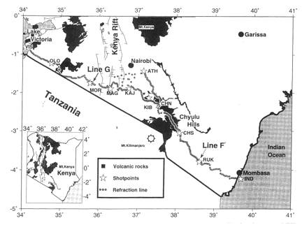
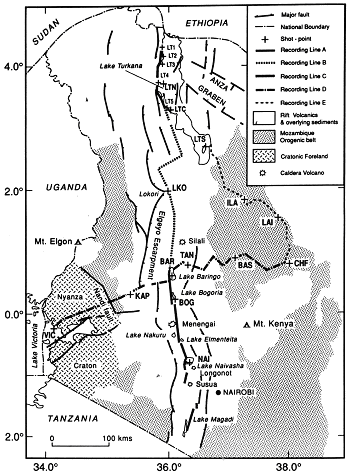
The location of the KRISP94 field work in the Kenya rift region.
Major scientific goals of the project were:
- To reveal the detailed crustal and upper-mantle structure under the southern Kenya rift and its flanks for several 100km to the west and to the east and their evolution.
- To study the relationship between deep crustal and uppermost mantle structure.
- To learn more on the development of sedimentary basins and volcanic features on the flanks and its relation to the Kenya rift.
- To obtain information on the temperature conditions underneath the rift and its flanks.
- To perform a particular integrated and calibrative study of seismological and petrological data in the Chyulu Hills.
- To understand the processes which are producing extension, uplift, and extensive magmatism.
This report is an introduction to a series of subsequent papers. It focuses on the technical description of the main seismic surveys of the KRISP 94 effort and summarizes the key results. During the teleseismic survey an array of 31 seismographs was deployed to record teleseismic, regional and local events for a period of about 3 months from June to August 1993. The elliptical array covered an area about 150km (N–S) × 100km (E–W) and spanned the central portion of the Chyulu Hills and its surroundings, with an average station spacing of 10–30 km. The seismic refraction-wide-angle reflection survey was carried out in a 2–week period in February 1994. It consisted of two profiles: one extending from Lake Victoria across the western flank and the southernmost Kenya rift at Lake Magadi, the other extending from Athi River near Nairobi across the eastern flank of the rift, traversing the Chyulu Hills and terminating at the Indian Ocean near Mombasa. A total of 204 mobile seismographs, with an average station interval of about 2km, recorded the energy of underwater and borehole explosions to distances of up to 730km.
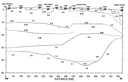
P-wave velocities in the Earth's crust and upper mantle along the KRISP94 transect from Lake Victoria
to the East African coast near Mombasa. Velocities in km/s; depths in km.
Key results are as follows:
- The crust reaches a maximum thickness of up to 44 km under the Chyulu Hills.
- Only a minor upwarping of the crust-mantle boundary is seen under the rift proper in the Lake Magadi area.
- To the west the crust shallows to about 34km near Lake Victoria, in contrast to the thickening of the crust further north from the central part of the rift near Lake Baringo towards the west.
- There is a steep rise of the Moho east of the Chyulu Hills towards the Indian Ocean.
- P-wave velocities in the uppermost mantle are above 8km/s except under the rift proper and under the Neogene volcanic centre of the Chyulu Hills, where the velocity is 7.9–8.0km/s.
- Under the Chyulu Hills, the Moho is replaced by a gradual crust–mantle transition, and the low velocities near the crust–mantle boundary extend to greater depths as evidenced by teleseismic tomography which indicates a velocity decrease of 3–5%, i.e. from 8.1–8.2km/s to at least 7.9km/s. Both effects are probably caused by the local recent volcanic activity, but cannot be interpreted as due to plume activity which is assumed to be present under the Nyanza craton further west.
- Gravity modelling and first preliminary results of the magnetotelluric measurements support the seismic-refraction and tomographic results. Furthermore, under the western flank the magnetotelluric and gravity data indicate increased conductivity and decreased density in the uppermost mantle below 60–80km depth.
An integrated model for the deep structure of the Chyulu Hills volcanic field, Kenya
O. Novak, J. R. R. Ritter, R. Altherr, V. Garasic, F. Volker, C. Kluge, T. Kaspar, G. F. Byrne, S. V. Sobolev and K. Fuchs
(from Tectonophysics, 1997, vol. 278, pages 187-209)
The Chyulu Hills, a 1.4 Ma B.P. to Holocene volcanic field located about 150 km to the east of the Kenya rift, is one of the few locations on Earth for which detailed geochemical (volcanic rocks), thermobarometric (xenoliths), seismological and gravity data are available. This paper combines these data to achieve an integrated seismic-petrological model for the deep structure of this volcanic field.
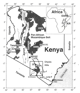
Location of the Chyulu Hills (Kenya) study area on the eastern flank of the East African Rift system.
Results of a wide-angle reflection and refraction experiment reveal an average crustal thickness of 40 km and a thickness of 20 km for the lower crust. Beneath the volcanic field, the crust thickens to about 44km. In this region a low-velocity body (LVZ) is modelled which extends from about 30 ± 5km depth to the Moho. The LVZ is characterised by an increased vP/vS-ratio ranging from 1.81 to 1.93 depending on the possible extents of this body. This is in contrast to the surrounding crust where a ratio of only about 1.76 is observed.
In the same area, the results of a teleseismic tomography study show a P-wave low-velocity anomaly of −3%. The seismic data can be explained by either an anorthositic body directly above the Moho in the region of the Chyulu Hills or by the presence of partial melt. Directly beneath the Chyulu Hills, a P-wave velocity of 7.9km/s is determined for the uppermost mantle; this velocity is 0.2–0.3km/s lower than that of the surrounding mantle region. The teleseismic tomography model suggests a P-wave low-velocity anomaly of −2.5 to −3.5% in the uppermost mantle (<70 km depth).
Widespread garnet-bearing pyroxenitic and lherzolitic mantle xenoliths are mostly well equilibrated and suggest an apparent lithospheric thickness of about 105 km. Most garnet-free spinel harzburgitic xenoliths and some garnet pyroxenitic xenoliths were significantly heated before they were sampled and erupted by the host magmas. Heating events lasted for less than 210ka as indicated by chemical diffusion profiles observed in orthopyroxene grains. It is suggested that heating was caused by stagnating magmas in the uppermost lithospheric mantle. At the same depth P-wave velocity perturbations of the tomographic model show a low-velocity zone directly underneath the youngest part (SE) of the volcanic field. At depths greater than about 70km, this low-velocity zone is shifted towards the east, away from the volcanic field.
[an error occurred while processing this directive]