IGCP Project 474
Images of the Earth's Crust & Upper Mantle

contact us: contact@earthscrust.org.au | about us
|
IGCP Project 474
Images of the Earth's Crust & Upper Mantle |
|
|
contact us: contact@earthscrust.org.au | about us
|
|
34th International
|
Updated: Dec 09, 2024 Large-scale seismic transects: images of the Earth's crust and mantle
Introduction
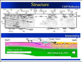
As part of the IGC program IGCP Project 474 (and its successor IGCP Project 559) sponsored session EIL-10 Large-scale seismic transects: Images of the Earth’s crust and mantle. The conveners were Dr Randell Stephenson (VU University, Amsterdam), Dr. Ramon Carbonell (CSIC Jaume Almera, Barcelona), Dr. Bruce Goleby (Geoscience Australia, Canberra), and Dr. Doug Finlayson (IGCP 474, Canberra) Most Earth science theory flows from an understanding of the geology at the surface of the Earth. However, seismic images of the Earth’s crust and upper mantle give us a detailed insight into the deeper geological structures and tectonic processes that shape the lithosphere and the modern landscapes. They are therefore relevant to natural resource exploration, the distribution and management of groundwater resources and the study and mitigation of natural hazards such as earthquakes. They define the large-scale processes that control the evolution of the landscape and soils. This symposium invites oral and poster contributions in which crustal-scale passive and/or active seismic imaging of the Earth’s crust and upper mantle forms the basis of regional, possibly interdisciplinary, studies of the tectonic processes controlling the architecture of orogenic belts, rifts, sedimentary basins, cratons, continental platforms and margins, and major intraoceanic features. There were 12 oral presentations and 9 poster presentations made during the IGCP 474 session. The presentations covered a wide-range of targets, from the point of view of tectonic age and setting as well as geographically. Images of cratonic lithosphere, from Eurasia as well as Australia dominated but Palaeozoic accreted belts as well as Mesozoic-Cenozoic orogens and basins also received attention. Most presentations dealt with images derived from seismic reflection profiling but other (especially passive seismic) methods were represented. A number of presentations proposed images of the Earth’s crust and mantle based on the integration of diverse geophysical datasets. Oral presentationsCrustal architecture across central Victoria, Australia, based on deep seismic reflection profiling. Integrating geology with deep seismic reflection profiles: New insights into the geodynamic and architectural evolution of the Eastern Goldfields Superterrane, western Australia. Reflection seismic images of the Early Precambrian crust of the major tectonic units within East European Craton: Data from the 1-EU, 4B, Tatseis geotraverses. North European transect A large seismic transect across the variscan belt of SW-Iberia: A multidisciplinary view. New constraints on crustal structure of the southern Iberian Variscaides from deep seismic reflection profiles (IBERSEIS, ALCUDIA Projects). From the east European to the Siberian craton: Controversies in the crustal and upper mantle models. Geological interpretation of the Siberian platform deep structure from transects Batolit and Altai - Severnaya Zemlya. Baikal explosion seismic transects. From continental collision to the Earth's deep water cycle: A preliminary synthesis of recent results from Project Hi-CLIMB. Sediment thickness in the IndoGangetic Plains inferred from Receiver function analysis Prospectus: A Trans-EurAsian Megatransect (TEAM). Poster presentationsSeismic image of the eastern edge of the Bay of Biscay: MARCONI deep seismic reflection profiles. Deep seismic reflection transects within the iberian peninsula: A geophysical data base. An upper mantle reflector beneath SW Iberia. Location and seismic constraint. Interpretation of wide-angle reflection and refraction recordings of Vibroseis signals and 3-D gravity modelling along FIRE4 profile, northern Finland. Seismic image of the Fennoscandian Shield along the Baltic Sea - White Sea transect. Deep crustal structure of the East European Craton in context of suggested Trans-EurAsian Megatransect: DOBRE-2: Integrated geophysical studies of the crust and upper mantle on the southern margin of the east European craton (Azov Sea-Crimea-Black sea area). Geotravese tatseis: One of the most significant components of trans-euroasian megatransform. Deep structure of the Eurasia-Pacific transition zone under the Geotraverse Project. The IN-DEPTH transect of the Himalaya-Tibet plateau. Selected paper summariesSediment thickness in the Indo-Gangetic Plains inferred from Receiver function analysisDavuluri, Srinagesh; Chadha, Rajender,National Geophysical Research Institute, Seismology, Hyderabad, India Email: srinagesh@ngri.res.in The Indo-Gangetic plain, a down warp of the Himalaya foreland is converted into flat plains by continuous sedimentation of Quaternary sediments. The thick sedimentary cover often obliterates the underlying geology and acts an impediment in understanding the tectonic evolution of the continents. The quantification of the sediments thickness is as important as mapping the underlying crustal structure. To unravel the structure we have been operating 10 broad band seismological stations in the Indo-Gangetic plains and the neighbouring Bundelkhand craton. Using receiver function technique the sedimentary thickness and the underlying crustal structure have been determined. The salient results were discussed and compared with the neighbouring Bundelkhand Massiff. Reflection seismic images of the Early Precambrian crust of the major tectonic units within East European Craton: Data from the 1-EU, 4B, Tatseis geotraversesMints, Michael1; Suleimanov, Arsen2; Zamozhniaya, Nadezhda2; Stupak, Vladimir21 Geological Institute of the Russian Academy of Sciences, Laboratory of the Early Precambrian tectonics, Moscow, Russian Federation;
In recent years a grid of Russian deep seismic profiles has been developed within the East European Craton and these have permitted observation and comparison of reflection seismic images of the main types of tectonic units in the Early Precambrian crust. The Archaean Karelia and Kursk cratons are typical granite-greenstone terranes partially destroyed during Palaeoproterozoic. Related seismic images are formed by the combination of:
In this presentation these features and their interpretation are discussed in detail. Deep structure of the Eurasia-Pacific transition zone under the Geotraverse ProjectZabarinskaya, Ludmila1; Rodnikov, Alexander2; Sergeyeva, Natalia21 Pavlovna, Geophysical Center, Russian Academy of Sciences, Moscow, Russian Federation; Email: mila@wdcb.ru The deep structure of the Eurasia-Pacific transition zone has been investigated under the Geotraverse International Project along deep cross-sections of the whole tectonosphere, including the lithosphere and the asthenosphere, based on the interpretation of both geological and geophysical data. The first geotraverse, was investigated in cooperation with Japanese geoscientists and crossed the region of the Japan Sea. The second geotraverse, was investigated in cooperation with Japanese and Chinese geoscientists and crossed the region of the Philippine Sea and the North China Plain. The third geotraverse crossed the region of the Okhotsk Sea. The total length of the geotraverses amounted to a few thousand kilometers with a depth of 100 km. New constraints on crustal structure of the southern Iberian Variscaides from deep seismic reflection profiles (IBERSEIS, ALCUDIA Projects)Carbonell, Ramon1; Simancas, Fernando2; Martínez-Poyatos, David2; Ayarza, Puy3; Palomeras, Imma1; Jabaloy, Antonio2; Gonzalez, Pablo4; Tejero, Rosa5; Matas, Jeronimo6; Martín-Parra, Luís6; Azor, Antonio2; González-Lodeiro, Francisco2; García-Lobón, Luís6; Pérez-Estaún, Andrés7; Mansilla, Luís81 CSIC-Institute of Earth Sciences, Structure and Dynamics of the Earth, Barcelona, Spain Email: rcarbo@ija.csic.es The IBERSEIS and ALCUDIA projects acquired two deep seismic reflection transects across the Variscan Orogen of southwestern Iberia. Jointly both transects complete almost 600 km of deep seismic reflection data, crossing the southern half of the Iberian Variscides and it offers a unique opportunity to study transpression tectonics. The whole transect extends from the Tajo basin southward till Gulf of Cadiz. The 20 s (twtt), deep seismic reflection image provides key constraints in the crustal structure of the southwestern Iberian. The seismic profile crosses key elements of the Variscan Orogen, runs across major tectonic units including the South Portuguese Zone (SPZ), Ossa Morena Zone (OMZ) and a large percentage of the Central Iberian Zone. The transect cuts across two major suture zones and some major geological structures and domains, with the Iberian Pyrite Belt being of the greatest interest, the Pulo do Lobo Unit, the Aracena metamophic belt, the Central Unit, the Santa Elena fault, the Almadén syncline, the Alcudia anticline, and the Toledo fault, and some major magnetic anomalies. From continental collision to the Earth's deep water cycle: A preliminary synthesis of recent results from Project Hi-CLIMBChen, Wang-Ping,University of Illinois, Geology, Urbana, United States Email: wpchen@uiuc.edu In the aftermath of plate tectonics, diffuse deformation of continents in general and the origin of the Tibetan plateau — the highest and the largest plateau on the planet — in particular have been on the leading edge of research. In this presentation, I put forth a preliminary synthesis of most recent results from Project Hi-CLIMB, an Integrated Study of the Himalayan-Tibetan Continental Lithosphere during Mountain Building. The mainstay of Hi-CLIMB is a hybrid linear/regional seismic array that has an aperture of over 800 km by 800 km. With over 200 stations, this is by far the most extensive deployment of broadband, transportable seismic arrays to date, with a dense spacing of only 3-8 km along the linear array. North European transectKorja, Annakaisa1; Heikkinen, Pekka1; Roslov, Yuri21 University of Helsinki, Institute of Seismology, Helsinki, Finland; Email: Annakaisa.Korja@helsinki.fi A nearly continuous, 3600 km long, NE-running North European Transect (NET) is combined from the existing deep seismic reflection data sets in the Baltic Sea (BABEL, 1600 km), Northern Finland (FIRE 4-4A, 580 km) and Russian Arctic (1-AR, 1440 km). The transect starts as with a BABELA marine profile from the Bay of Lybeck, runs through the Baltic and Bothnian Seas (BABEL B,C,1,3&4), and continues with FIRE4&4A profile crossing northern Finland. In the Kola Peninsula region the transect is continues with profile Line 1-AR (1440 km total length with 1330 km at sea and 110 km on land) connecting the super-deep hole-3 on the Kola Peninsula (town of Zapolarny, Russia) with the hole 1-Hayes on Franz Joseph Land and transects the Barents Sea. Geologically the North European Transect covers the transition from Phanerozoic Europe to Precambrian Europe and back to the Phanerozoic Barents Sea shelf. A large seismic transect across the variscan belt of SW-Iberia: A multidisciplinary viewPalomeras, Imma1; Fernandez, Manel1; Carbonell, Ramon1; Simancas, Fernando2; Ayarza, Puy3; Martinez Poyatos, David2; Azor, Antonio2; Gonzalez-Lodeiro, Francisco2; Perez-Estaun, Andres11 Inst. of Earth Sciences 'Jaume Almera' - CSIC, Barcelona, Spain; Email: ipalomeras@ija.csic.es This paper describes a multidisciplinary geophysical study conducted along a seismic transect in the SW-Iberian Peninsula. This study integrates the crustal structure, geometry and composition obtained from normal incidence and wide-angle seismic reflection data with other observables (geoid, gravity and topography). The IBERSEIS is a 300 km long high resolution deep normal incidence seismic reflection survey which provided the internal architecture of the lithosphere across the Variscan orogen of SW Iberia. The most prominent feature of the IBERSEIS profile is a 140 km long high amplitude reflective body (IRB) located in the middle crust in the northern part of the transect. Two wide-angle seismic transects acquired in the same area provided the seismic velocity (Vp) distribution within the crust and the upper mantle. The wide-angle data constrained the IRB as a high velocity body and revealed that it is most probably part of a series of mafic dikes emplaced within the crust. An upper mantle reflector beneath SW Iberia. Location and seismic constraintsAyarza, Puy1; Palomeras, Inma2; Simancas, Fernando3; Carbonell, Ramón2; Martínez-Poyatos, David3; Azor, Antonio3; Pérez-Estaún, Andrés2; Gonzalez-Lodeiro, Francisco31 Salamanca University, Geology, Salamanca, Spain; Email: puy@usal.es Long wide angle seismic reflection profiles benefit from energy reflected at supercritical angles to image deep interfaces which may feature low impedance contrasts. Recent examples are the late seismic events identified in the IBERSEIS wide-angle recordings. This experiment acquired two ~300 km long profiles which sampled three different tectonic zones in the SW Iberian Massif. The seismic sections provide information concerning upper mantle reflectivity down to depths of 70 km. Slightly above this depth, a mantle reflector has been observed at offsets over 180 km and has been modelled as a fairly continuous feature in all the shot records where the distance between shot and receivers is long enough as to allow its identification. However, this feature does not appear at all or at least is not as continuous in coincident or neighbouring vertical incidence deep seismic reflection profiles. Accordingly, we suggest that the nature of this boundary is probably lithological and that it implies a subtle velocity/density contrast only visible at high incidence angles. Deep seismic reflection transects within the iberian peninsula: A geophysical data baseGaite, Beatriz; Palomeras, Imma; Carbonell, Ramon
Email: bgaite@ija.csic.es A relatively large number of large-scale seismic reflection transects acquired in the Iberia Peninsula has been compiled into a geophysical data base. These data has been made available through an easy access internet web page (http://xeon.ija.csic.es ) . The key objective of this effort is to provide ready access to geophysical data, such as images of the Earth's basement geology and deep crust and upper mantle, and thus contribute to more informed debate on issues related to geological paradigms (theories), tectonic processes (plate tectonics, dynamic processes), the natural environment (landscapes, soils, erosion), natural hazards (earthquakes, volcanic eruptions, tsunamis) and the sustainable use of natural resources including soil, water, energy (oil, gas, coal, geothermal), and minerals. Many images of the Earth included in this database were collected along transects, which are long, narrow corridors across the Earth's surface. These images represent two-dimensional slices extending from the surface to depths as great as 100km. Integrating geology with deep seismic reflection profiles: new insights into the geodynamic and architectural evolution of the Eastern Goldfields Superterrane, Western AustraliaBlewett, Richard1; Czarnota, Karol1; Jones, Leonie1; Henson, Paul1; Goscombe, Ben2; Goleby, Bruce11 Geoscience Australia, Canberra, Australia Email: richard.blewett@ga.gov.au Deep seismic reflection profiles provide a unique view of the architecture of the crust and upper mantle, leading to inferences regarding its geodynamic evolution. The Eastern Goldfields Superterrane (EGST) in Western Australia is a classic Archaean granite-greenstone terrane that hosts some of the world's best gold and nickel deposits. Defining the geodynamics and its resultant architecture are two critical components in understanding these major mineral systems. Two major across-strike seismic transects totalling 614 km (91EGF01 and 01AGSNY1) have been acquired, and these are augmented by numerous shorter seismic traverses. The result is a comprehensive grid of traverses that have been integrated with the geology and the potential field geophysics to create a series of 3D models (maps). The post seismic paradigm for interpreting the folds (domes) and faults was one of thrust duplexing in an overall cyclic contractional-extensional tectonic setting. Crustal architecture across central Victoria, Australia, based on deep seismic reflection
|
| Disclaimer | Copyright | |


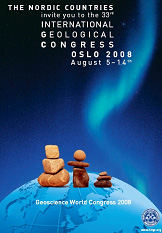 The 33rd International Geological Congress was held in Oslo, Norway, during 6-14 August, 2008. For nine days 6,000 scientists from 113 countries took part in lively discussions within almost every conceivable aspect of geology.
 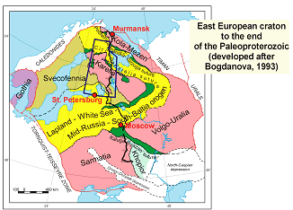 Email:
 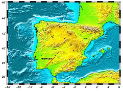 Institut of Earth Sciences Jaume Almera (CSIC), Barcelona, Spain
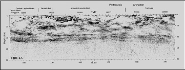
 Cornell University, Institute for the Study of the Continents, Ithaca, United States
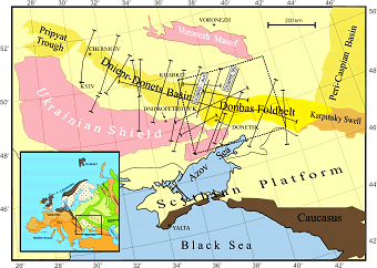 The southern part of the eastern European continental landmass consists mainly of a thick platform of Vendian and younger sediments overlying Precambrian basement, part of the East European Platform (EEP). The Scythian Platform (SP) lies between the EEP and the (mainly Alpine) deformed belt running from Dobrogea (Romania) to Crimea (Ukraine) and the Greater Caucasus (Russia), along the northern margin of the Black Sea. Hard constraints on the Palaeozoic history on the SP are very sparse and little is known of its crustal structure in this area. This poster paper presents preliminary results of a new multidisciplinary project that will fill some of this gap. The new project is called DOBRE-2 (as it forms a prolongation of the successful DOBRE project executed in 1999-2001).